
-
Distributed Anomaly Detection using 1-class SVM for Vertically Partitioned Data
There has been a tremendous increase in the volume of sensor data collected over the last decade for different monitoring tasks. For example, petabytes of earth science data are... -
CASSINI HIGH RATE DETECTOR V4.0
The High Rate Detector (HRD) from the University of Chicago is an independent part of the CDA instrument on the Cassini Orbiter that measures the dust flux and particle mass... -
ISS_COORDS_2021-05-06
This data represents the best estimated real-time trajectory and local sightings opportunities for the International Space Station (ISS) as generated by the Trajectory... -
ROSETTA-ORBITER MARS OSIWAC 3 MARS RDR V2.0
This CODMAC level 3 data set contains radiometric calibrated image data in W/m^2/sr/nm, acquired by the OSIRIS Wide Angle Camera on the Rosetta spacecraft during the MARS SWING-... -
NOAA-21 VIIRS Global Mapped Diffuse Attenuation Coefficient for Downwelling Irradiance (KD) - Near Real Time (NRT) Data, version R2022.0
The Ocean Biology DAAC produces near real-time (quicklook) products using the best-available combination of ancillary data from meteorological and ozone data. As such, the... -
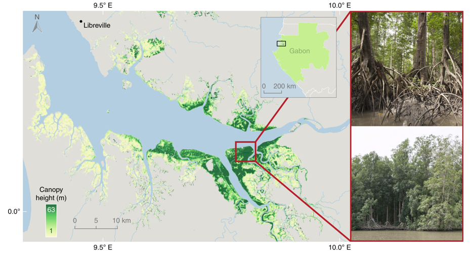
Global Mangrove Distribution, Aboveground Biomass, and Canopy Height
This dataset characterizes the global distribution, biomass, and canopy height of mangrove-forested wetlands based on remotely sensed and in situ field measurement data.... -
Multivariate Time Series Search
Multivariate Time-Series (MTS) are ubiquitous, and are generated in areas as disparate as sensor recordings in aerospace systems, music and video streams, medical monitoring,... -
EASE-Grid Land-Ocean-Coastline-Ice Masks Derived from Boston University MODIS/Terra Land Cover Data, Version 1 NGDA
These Land-Ocean-Coastline-Ice (LOCI) files provide land classification masks derived from the Boston University MOD12Q1 V004 MODIS/Terra 1 km Land Cover Product (Friedl et al.... -
Gazetteer of Planetary Nomenclature: Venus: 1:5 million-scale Magellan Imagery
Magellan imagery of Venus approved by the International Astronomical Union (IAU). -
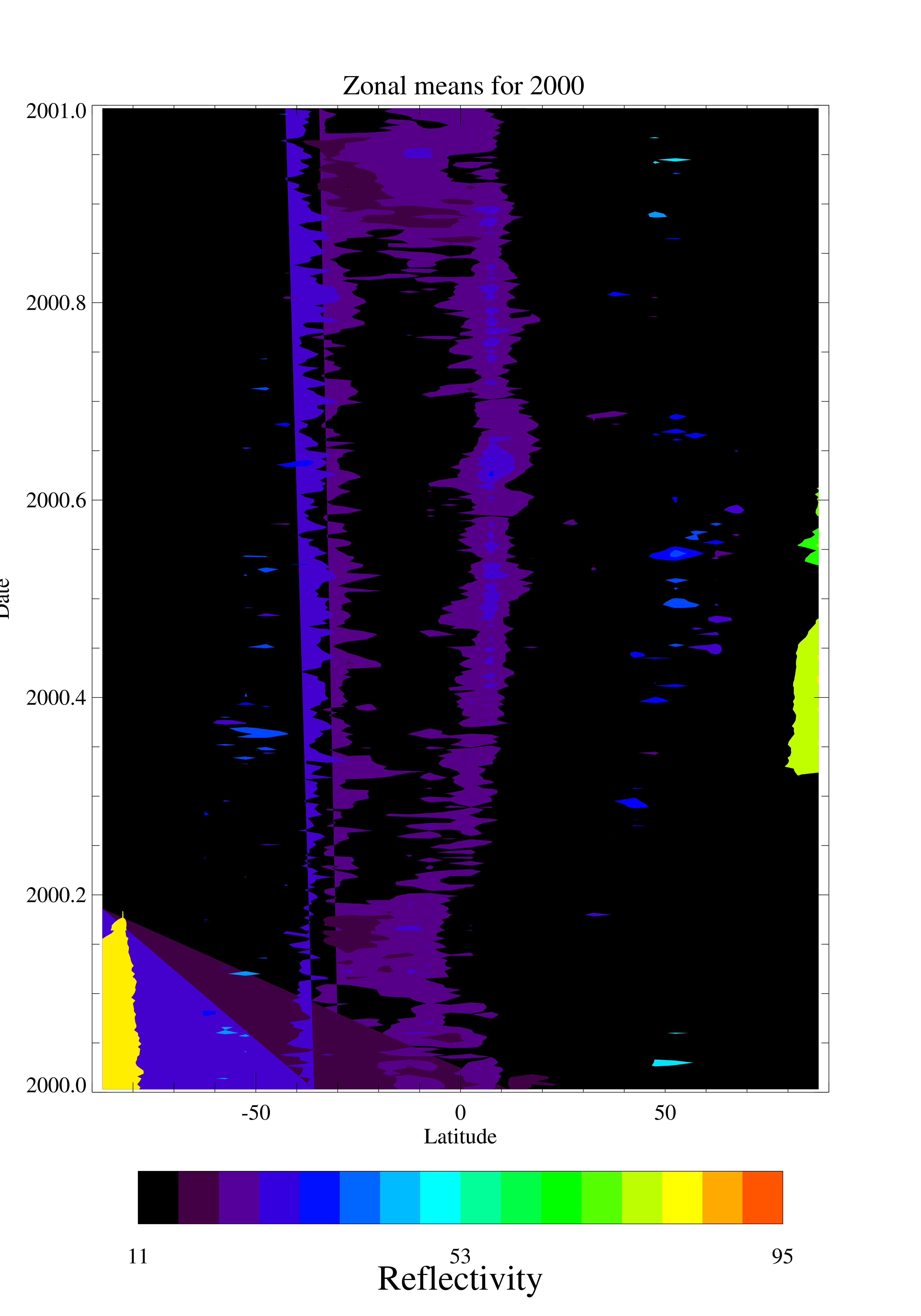
TOMS EP UV Reflectivity Daily and Monthly Zonal Means V008 (TOMSEPL3zref) at GES DISC
This Earth Probe (EP) Total Ozone Mapping Spectrometer (TOMS) version 8 daily zonal means data product contains Lambertian effective surface reflectivity values (Rayleigh... -
OMPS-NPP L2 NP Ozone (O3) Vertical Profile swath orbital
The OMPS-NPP L2 NP Ozone (O3) Total Column swath orbital product provides ozone profile retrievals from the Ozone Mapping and Profiling Suite (OMPS) Nadir-Profiler (NP)... -
Gazetteer of Planetary Nomenclature
Planetary nomenclature, like terrestrial nomenclature, is used to uniquely identify a feature on the surface of a planet or satellite so that the feature can be easily located,... -
GHRSST Level 4 MW_IR_OI Global Foundation Sea Surface Temperature analysis version 5.0 from REMSS NGDA
A Group for High Resolution Sea Surface Temperature (GHRSST) global Level 4 sea surface temperature analysis produced daily on a 0.09-degree grid at Remote Sensing Systems. This... -
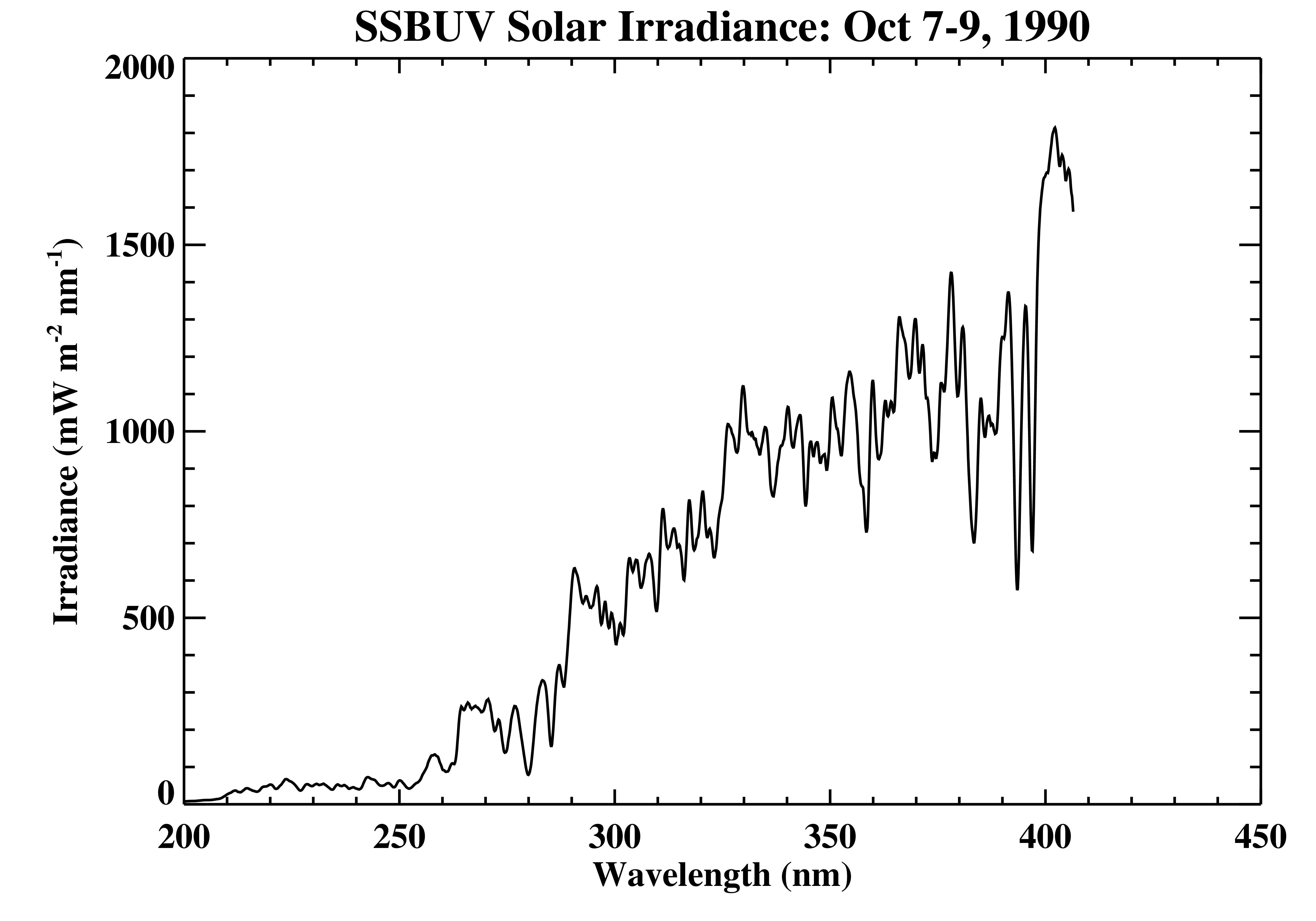
Shuttle SBUV (SSBUV) Solar Spectral Irradiance V008 (SSBUVIRR) at GES DISC
The Shuttle Solar Backscatter Ultraviolet (SSBUV) level-2 irradiance data are available for eight space shuttle missions flown between 1989 and 1996. SSBUV, a successor to the... -
Measurements taken in the Aegean and Black seas onboard the R/V Akwanavt
Measurements taken in the Aegean and Black seas during 1997 onboard the R/V Akwanavt. -
Digital Elevation Models for the Global Change Research Wetland, Maryland, USA, 2016
This dataset contains four alternative digital elevation models (DEMs) at 1 m resolution and model performance statistical metrics for the Global Change Research Wetland (GCReW)... -
Gazetteer of Planetary Nomenclature: Saturnian System: Titan
These images display several of Saturn's moons approved by the International Astronomical Union (IAU). -
TOVS GLA MONTHLY GRIDS from NOAA-11 V01 (TOVSAMNH) at GES DISC
This dataset (TOVSAMNH) contains the TIROS Operational Vertical Sounder (TOVS) level 3 geophysical parameters derived using data from NOAA-11 and the physical retrieval method... -
ACT-America: L1 Raw, Uncalibrated In-Situ CO2, CO, and CH4 Mole Fractions from Towers
This dataset provides Level 1 (L1) in situ atmospheric carbon dioxide (CO2), carbon monoxide (CO), and methane (CH4) concentrations as measured on a network of instrumented...

Official websites use .gov
A
.gov website belongs to an official government
organization in the United States.
Secure .gov websites use HTTPS
A
lock (
) or https:// means you’ve safely connected to
the .gov website. Share sensitive information only on official,
secure websites.