
-
Global MODIS and FLUXNET-derived Daily Gross Primary Production, V2 NGDA
This dataset provides global gridded daily estimates of gross primary production (GPP) and uncertainties at 0.05-degree resolution for the period 2000-03-01 to the recent past.... -
ABoVE: Light-Curve Modelling of Gridded GPP Using MODIS MAIAC and Flux Tower Data NGDA
This dataset contains gridded estimations of daily ecosystem Gross Primary Production (GPP) in grams of carbon per day at a 1 km2 spatial resolution over Alaska and Canada from... -
Global-Gridded Daily Methane Emissions Climatology from Lake Systems, 2003-2015
This dataset provides global gridded information on lake surface area and open water CH4 emissions at a resolution of 0.25-degree x 0.25-degree for an annual climatology... -
Satellite Observations of Arctic Change, Version 1 NGDA
The purpose of this site is to expose NASA satellite data and research on Arctic change in the form of maps that illustrate the changes taking place in the Arctic over time. A... -
BOREAS TE-20 Site Characteristics Data
The BOREAS TE-20 team collected several data sets for use in developing and testing models of forest ecosystem dynamics. This data set contains measurements of site... -
MODIS/Terra+Aqua Direct Broadcast Burned Area Monthly L3 Global 500m SIN Grid V061 NGDA
The Terra and Aqua combined MCD64A1 Version 6.1 Burned Area data product is a monthly, global gridded 500 meter (m) product containing per-pixel burned-area and quality... -
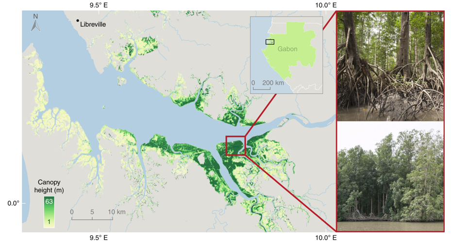
Global Mangrove Distribution, Aboveground Biomass, and Canopy Height
This dataset characterizes the global distribution, biomass, and canopy height of mangrove-forested wetlands based on remotely sensed and in situ field measurement data.... -
Digital Elevation Models for the Global Change Research Wetland, Maryland, USA, 2016
This dataset contains four alternative digital elevation models (DEMs) at 1 m resolution and model performance statistical metrics for the Global Change Research Wetland (GCReW)... -
NLDAS Noah Land Surface Model L4 Monthly 0.125 x 0.125 degree V2.0 (NLDAS_NOAH0125_M) at GES DISC
This data set contains fifty-two fields simulated from the Noah land-surface model (LSM) for Phase 2 of the North American Land Data Assimilation System (NLDAS-2). The data are... -
GEWEX SRB Integrated Product (Rel-4) Shortwave Monthly Average by Local Fluxes
GEWEXSRB_Rel4-IP_Shortwave_monthly_local is the Global Energy and Water Exchanges (GEWEX) Surface Radiation Budget (SRB) Integrated Product (Rel-4) Shortwave Monthly Average by... -
MODIS/Terra+Aqua Leaf Area Index/FPAR 4-Day L4 Global 500m SIN Grid V061 NGDA
The MCD15A3H Version 6.1 Moderate Resolution Imaging Spectroradiometer (MODIS) Level 4, Combined Fraction of Photosynthetically Active Radiation (FPAR), and Leaf Area Index... -
Global Vegetation Greenness (NDVI) from AVHRR GIMMS-3G+, 1981-2022
This dataset holds the Global Inventory Modeling and Mapping Studies-3rd Generation V1.2 (GIMMS-3G+) data for the Normalized Difference Vegetation Index (NDVI). NDVI was based... -
Delta-X: UAVSAR L2 Interferometric Products, MRD, Louisiana, 2021
This dataset contains georeferenced UAVSAR Level 2 (L2) interferometric products for Delta-X flight lines acquired during the spring (2021-03-27 to 2021-04-18) and fall... -
FIREX-AQ NOAA-MET Twin Otter Data
FIREXAQ_N46_Data are the wind profile and fire temperature data collected onboard the NOAA-MET Twin Otter during FIREX-AQ. This product includes data collected by the Nighttime... -
Trends of Thermal, Wetness, and Vegetative Change in the Circumpolar Arctic
This dataset provides estimates of trends in temperature, moisture, and vegetation changes over the circumpolar Arctic. Time series trends were measured by the Theil-Sen slope...

Official websites use .gov
A
.gov website belongs to an official government
organization in the United States.
Secure .gov websites use HTTPS
A
lock (
) or https:// means you’ve safely connected to
the .gov website. Share sensitive information only on official,
secure websites.