
-
MISR FIRSTLOOK radiometric camera-by-camera Cloud Mask V002
This is the FIRSTLOOK Radiometric Camera-by-camera Cloud Mask (RCCM) product. It contains initial estimated classifications of pixels/regions as clear or cloudy. It also has... -
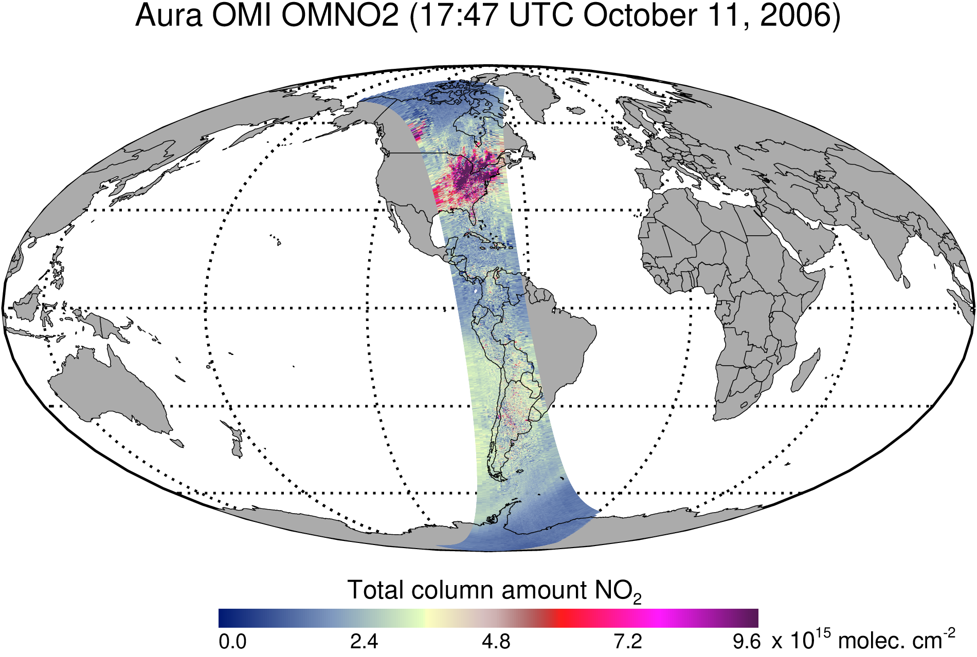
OMI/Aura Nitrogen Dioxide (NO2) Total and Tropospheric Column 1-orbit L2 Swath 13x24 km V003 (OMNO2) at GES DISC
The Version 4.0 Aura Ozone Monitoring Instrument (OMI) Nitrogen Dioxide (NO2) Standard Product (OMNO2) is now available from the NASA Goddard Earth Sciences Data and Information... -
Daily and Annual PM2.5 Concentrations for the Contiguous United States, 1-km Grids, Version 1.10 (2000-2016)
The Daily and Annual PM2.5 Concentrations for the Contiguous United States, 1-km Grids, Version 1.10 (2000-2016) data set includes predictions of PM2.5 concentration in grid... -
GEOS-Carb CASA-GFED Monthly Fire Fuel NPP Rh NEE Fluxes 0.5 degree x 0.5 degree V2 (GEOS_CASAGFED_M_FLUX) at GES DISC
This product provides Monthly average Net Primary Production (NPP), heterotrophic respiration (Rh), wildfire emissions (FIRE), and fuel wood burning emissions (FUEL) derived... -
ATom: Ozone Profiles from Ozonesonde Instrument, Antarctica, Fiji, and Hawaii
This dataset contains ozone measurements from the Ozonesonde instrument in Antarctica, Hawaii, and Fiji taken during the Atom-4 campaign. The Electrochemical Concentration Cell... -
GPM Ground Validation Pluvio Precipitation Gauges OLYMPEX V1
The GPM Ground Validation Pluvio Precipitation Gauges OLYMPEX dataset contains one-minute precipitation rate and precipitation accumulation measurements, as well as start and... -
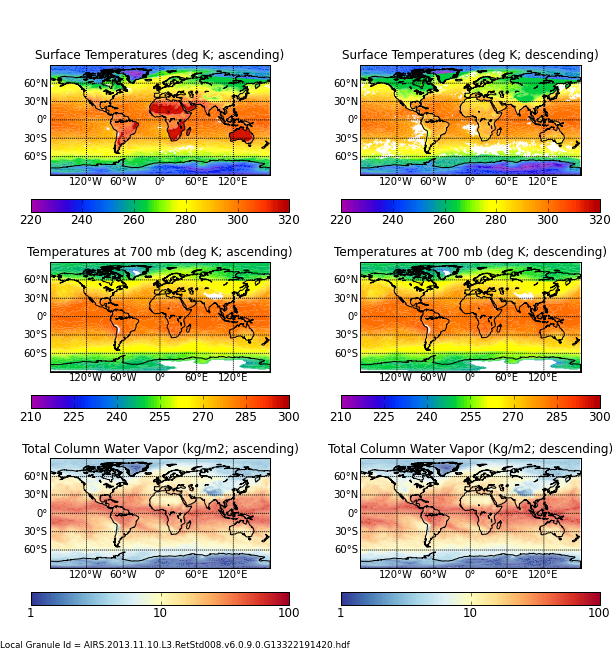
AIRS/Aqua L3 8-day Support Multiday Product (AIRS+AMSU) 1 degree x 1 degree V006 (AIRX3SP8) at GES DISC
The Atmospheric Infrared Sounder (AIRS) is a grating spectrometer (R = 1200) aboard the second Earth Observing System (EOS) polar-orbiting platform, EOS Aqua. In combination... -
GPM Ground Validation Autonomous Parsivel Unit (APU) OLYMPEX V1
The GPM Ground Validation Autonomous Parsivel Unit (APU) OLYMPEX dataset was collected during the OLYMPEX field campaign held at Washington's Olympic Peninsula during the... -
SAGE III/ISS L2 Monthly Lunar Event Species Profiles (NetCDF) V053
g3blmnc_53 is the Stratospheric Aerosol and Gas Experiment III (SAGE III) on the International Space Station (ISS) (SAGE III/ISS) Level 2 Monthly Lunar Event Species Profiles... -
SASS (Subsonics Assessment) Ozone and NOx Experiment (SONEX) Photolysis Frequencies (J-Values)
SONEX_jValue_AircraftInSitu_DC8_Data_1 is the photolysis frequencies (j-values) measured along the DC-8 flight by the Scanning Actinic Flux Spectroradiometers (SAFS). Data... -
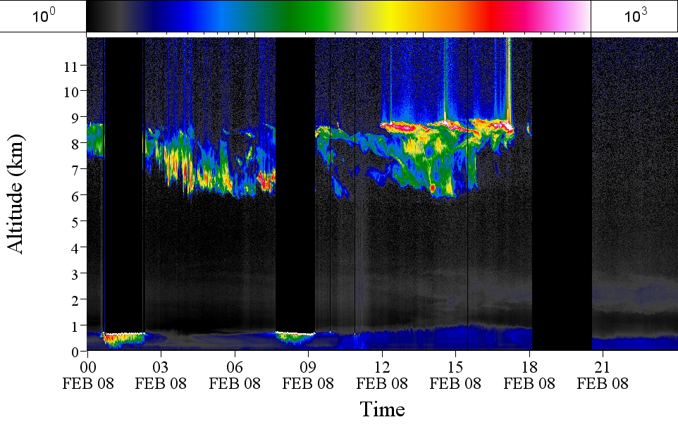
GPM GROUND VALIDATION AEROSOL AND WATER VAPOR LIDAR QUICKLOOKS GCPEX V1
The GPM Ground Validation Aerosol and Water Vapor Lidar Quicklooks GCPEx dataset contains imagery generated from the GPM Cold-season Precipitation Experiment (GCPEx) campaign... -
FLDAS Noah Land Surface Model L4 Global Monthly 0.1 x 0.1 degree (GDAS and CHIRPS-PRELIM) V001 (FLDAS_NOAH01_CP_GL_M) at GES DISC
This dataset contains a series of land surface parameters simulated from the Noah 3.6.1 model in the Famine Early Warning Systems Network (FEWS NET) Land Data Assimilation... -
GPM GROUND VALIDATION AUTONOMOUS PARSIVEL UNIT (APU) IPHEx V1
The GPM Ground Validation NASA Autonomous Parsivel Unit (APU) IPHEx dataset was acquired by multiple parsivel instruments during the GPM Integrated Precipitation and Hydrology... -
First ISCCP Regional Experiment (FIRE) Atlantic Stratocumulus Transition Experiment (ASTEX) Rawinsonde Level 1 Data
The First ISCCP Regional Experiments have been designed to improve data products and cloud/radiation parameterizations used in general circulation models (GCMs). Specifically,... -
MERRA-2 instU_3d_asm_Np: 3d,diurnal,Instantaneous,Pressure-Level,Assimilation,Assimilated Meteorological Fields 0.625 x 0.5 degree V5.12.4 (M2IUNPASM) at GES DISC
M2IUNPASM (or instU_3d_asm_Np) is an instantaneous 3-dimensional monthly diurnal means data collection in Modern-Era Retrospective analysis for Research and Applications version... -
SAFARI 2000 TOMS Tropospheric Ozone Data, Southern Africa Subset, Dry Season 2000
Tropical Tropospheric Ozone (TTO) data from Earth Probe (EP) Total Ozone Mapping Spectrometer (TOMS) for the period of August 8-September 29, 2000 were processed and provided by... -
Satellite Observations of Arctic Change, Version 1 NGDA
The purpose of this site is to expose NASA satellite data and research on Arctic change in the form of maps that illustrate the changes taking place in the Arctic over time. A...

Official websites use .gov
A
.gov website belongs to an official government
organization in the United States.
Secure .gov websites use HTTPS
A
lock (
) or https:// means you’ve safely connected to
the .gov website. Share sensitive information only on official,
secure websites.