
-
SAGE III/ISS L2 Monthly Lunar Event Species Profiles (NetCDF) V053
g3blmnc_53 is the Stratospheric Aerosol and Gas Experiment III (SAGE III) on the International Space Station (ISS) (SAGE III/ISS) Level 2 Monthly Lunar Event Species Profiles... -
Multivariate Time Series Search
Multivariate Time-Series (MTS) are ubiquitous, and are generated in areas as disparate as sensor recordings in aerospace systems, music and video streams, medical monitoring,... -
Digital Elevation Models for the Global Change Research Wetland, Maryland, USA, 2016
This dataset contains four alternative digital elevation models (DEMs) at 1 m resolution and model performance statistical metrics for the Global Change Research Wetland (GCReW)... -
Gazetteer of Planetary Nomenclature
Planetary nomenclature, like terrestrial nomenclature, is used to uniquely identify a feature on the surface of a planet or satellite so that the feature can be easily located,... -
Earth Radiation Budget Experiment (ERBE) S-10N (Nonscanner-only) Wide Field of View (WFOV) Numerical Filter (NF) Radiant Flux and Albedo Edition 2 in Native Format
ERBE_S10N_WFOV_NF_Edition2 is the Earth Radiation Budget Experiment (ERBE) S-10N (Nonscanner-only) Wide Field of View (WFOV) Numerical Filter (NF) Radiant Flux and Albedo... -
Gazetteer of Planetary Nomenclature
Planetary nomenclature, like terrestrial nomenclature, is used to uniquely identify a feature on the surface of a planet or satellite so that the feature can be easily located,... -
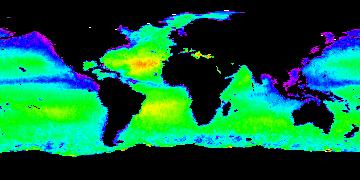
Aquarius Official Release Level 3 Sea Surface Salinity Standard Mapped Image Daily Data V5.0
Aquarius Level 3 sea surface salinity (SSS) standard mapped image data contains gridded 1 degree spatial resolution SSS averaged over daily, 7 day, monthly, and seasonal time... -
nu-Anomica algorithm
One-class nu-Support Vector machine (SVMs) learning technique maps the input data into a much higher dimensional space and then uses a small portion of the training data... -
Aquarius Official Release Level 3 Sea Surface Salinity Standard Mapped Image 7-Day Running Mean Data V5.0
Aquarius Level 3 sea surface salinity (SSS) standard mapped image data contains gridded 1 degree spatial resolution SSS averaged over daily, 7 day, monthly, and seasonal time... -
Aquarius Official Release Level 3 Sea Surface Density Standard Mapped Image Descending 7-Day Data V5.0
Aquarius Level 3 sea surface density standard mapped image data contains gridded 1 degree spatial resolution density data averaged over daily, 7 day, monthly, and seasonal time... -
LBA-ECO LC-24 Historical Roads of the Legal Amazon: 1968-1993
This data set contains ESRI shapefiles of historical roads (basin-wide federal and state roads) in nine Brazilian states for the Legal Amazon: Amazonas, Para, Acre, Rondonia,... -
CARVE: L1 In-situ Carbon and CH4 Flux and Meteorology at EC Towers, Alaska, 2011-2015
This data set provides ground in situ flux and meteorological science data from fixed instruments at three eddy covariance tower sites located in the Alaskan Arctic tundra. Real... -
SAGE III/ISS L2 Solar Event Species Profiles (HDF5) V053
g3bssp_53 is the Stratospheric Aerosol and Gas Experiment III (SAGE III) on the International Space Station (ISS) (SAGE III/ISS) Level 2 Solar Event Species Profiles (HDF5) V053... -
DXC'13 Industrial Track Sample Data
The sample scenarios provided here are competition scenarios from previous DXC competitions. They are identical to the competition data associated with previous years' projects,... -
Aquarius Official Release Level 3 Sea Surface Salinity Standard Mapped Image Descending Mission Cumulative Data V5.0
Aquarius Level 3 sea surface salinity (SSS) standard mapped image data contains gridded 1 degree spatial resolution SSS averaged over daily, 7 day, monthly, and seasonal time... -
Aquarius Official Release Level 3 Sea Surface Spiciness Standard Mapped Image Seasonal Data V5.0
Aquarius Level 3 sea surface spiciness standard mapped image data contains gridded 1 degree spatial resolution spice data averaged over daily, 7 day, monthly, and seasonal time... -
Cloud-Precipitation Hybrid Regimes (MODIS-IMERG) in 15S-15N
Cloud-Precipitation Hybrid Regimes with MODIS C6.1 2D joint histogram of CTP and COT (total 42 bins) and IMERG v06B precipitation histogram (total 6 bins) derived in 15S-15N... -
CERES ERBE-like Instantaneous TOA Estimates NOAA-20 FM6 Edition1
CER_ES8_NOAA20-FM6_Edition1 data are ERBE-like instantaneous TOA estimates. Edition1 data are for instrument validation and are not suited for science publications. The Clouds... -
A Concise Experiment Plan for the Arctic-Boreal Vulnerability Experiment
This document presents the Concise Experiment Plan for NASA's Arctic-Boreal Vulnerability Experiment (ABoVE) to serve as a guide to the Program as it identifies the research to... -
Aquarius Official Release Level 3 Rain-flagged Sea Surface Salinity Standard Mapped Image Seasonal Climatology Data V5.0
Aquarius Level 3 sea surface salinity (SSS) rain-flagged standard mapped image data contains gridded 1 degree spatial resolution SSS averaged over daily, 7 day, monthly, and...

Official websites use .gov
A
.gov website belongs to an official government
organization in the United States.
Secure .gov websites use HTTPS
A
lock (
) or https:// means you’ve safely connected to
the .gov website. Share sensitive information only on official,
secure websites.