
-
ROSETTA-ORBITER STEINS RPCIES 2 AST1 V1.0
This dataset contains EDITED RAW DATA of the RPCIES instrument taken during the asteroid Steins encounter (AST1). Included are the data taken between 11 Jul 2008 and 06 Sep 2008. -
GPM Ground Validation Pluvio Precipitation Gauges OLYMPEX V1
The GPM Ground Validation Pluvio Precipitation Gauges OLYMPEX dataset contains one-minute precipitation rate and precipitation accumulation measurements, as well as start and... -
VEMAP 1: U.S. Soil
An integrated input data set for ecosystem and vegetation modeling for the conterminous United States: Soil -
Woman skeletal muscle transcriptome with bed rest and countermeasures.
Microgravity has a dramatic impact on human physiology illustrated in particular with skeletal muscle impairment. A thorough understanding of the mechanisms leading to loss of... -
Global Population Density Grid Time Series Estimates
The Global Population Density Grid Time Series Estimates provide a back-cast time series of population density grids based on the year 2000 population grid from SEDAC's Global... -
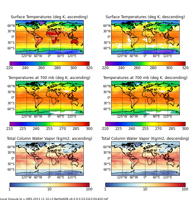
AIRS/Aqua L3 8-day Support Multiday Product (AIRS+AMSU) 1 degree x 1 degree V006 (AIRX3SP8) at GES DISC
The Atmospheric Infrared Sounder (AIRS) is a grating spectrometer (R = 1200) aboard the second Earth Observing System (EOS) polar-orbiting platform, EOS Aqua. In combination... -
Nimbus-7 Coastal Zone Color Scanner (CZCS) Data Regional Data
The Coastal Zone Color Scanner Experiment (CZCS) was the first instrument devoted to the measurement of ocean color and flown on a spacecraft. Although other instruments flown... -
GPM Ground Validation Autonomous Parsivel Unit (APU) OLYMPEX V1
The GPM Ground Validation Autonomous Parsivel Unit (APU) OLYMPEX dataset was collected during the OLYMPEX field campaign held at Washington's Olympic Peninsula during the... -
Aviation Safety Reporting System: Parachutist / Aircraft Conflicts
A sampling of reports involving parachuting activity and conflicts with aircraft. -
SAGE III/ISS L2 Monthly Lunar Event Species Profiles (NetCDF) V053
g3blmnc_53 is the Stratospheric Aerosol and Gas Experiment III (SAGE III) on the International Space Station (ISS) (SAGE III/ISS) Level 2 Monthly Lunar Event Species Profiles... -
NASA 3D Models: Deep Space 1
This .stl file was produced by scaling the original model and converting it directly to .stl format. -
SASS (Subsonics Assessment) Ozone and NOx Experiment (SONEX) Photolysis Frequencies (J-Values)
SONEX_jValue_AircraftInSitu_DC8_Data_1 is the photolysis frequencies (j-values) measured along the DC-8 flight by the Scanning Actinic Flux Spectroradiometers (SAFS). Data... -
ROSETTA-ORBITER STEINS MIRO 3 AST1 STEINS V1.0
This data set contains radiometrically calibrated Spectroscopic and Continuum data, in the form of table files, taken during the Steins Fly-by phase of the Rosetta mission by... -
LP Moon MAG Level 4 Lunar Magnetic Field Time Series V1.0
LP magnetometer (MAG) Level 2 Data (CODMAC Level 4). Selected and filtered time series data at 5 second intervals. Approximate measurements of the lunar crustal magnetic field... -
Discovering Anomalous Aviation Safety Events Using Scalable Data Mining Algorithms
The worldwide civilian aviation system is one of the most complex dynamical systems created. Most modern commercial aircraft have onboard flight data recorders that record... -
GPM GROUND VALIDATION AEROSOL AND WATER VAPOR LIDAR QUICKLOOKS GCPEX V1
The GPM Ground Validation Aerosol and Water Vapor Lidar Quicklooks GCPEx dataset contains imagery generated from the GPM Cold-season Precipitation Experiment (GCPEx) campaign... -
VIIRS/NPP BRDF/Albedo Quality Daily L3 Global 500m SIN Grid V001
The NASA/NOAA Suomi National Polar-orbiting Partnership (Suomi NPP) Visible Infrared Imaging Radiometer Suite (VIIRS) Bidirectional Reflectance Distribution Function (BRDF) and... -
FLDAS Noah Land Surface Model L4 Global Monthly 0.1 x 0.1 degree (GDAS and CHIRPS-PRELIM) V001 (FLDAS_NOAH01_CP_GL_M) at GES DISC
This dataset contains a series of land surface parameters simulated from the Noah 3.6.1 model in the Famine Early Warning Systems Network (FEWS NET) Land Data Assimilation...

Official websites use .gov
A
.gov website belongs to an official government
organization in the United States.
Secure .gov websites use HTTPS
A
lock (
) or https:// means you’ve safely connected to
the .gov website. Share sensitive information only on official,
secure websites.