
-
NACP Greenhouse Gases Multi-Source Data Compilation, 2000-2009
This data set is a collection of measurements of carbon dioxide (CO2) and non-CO2 greenhouse gases made across North America by nine independent atmospheric monitoring networks... -
RapidScat Level 2A Surface Flagged Sigma-0 and Attenuations in 25km Swath Grid Version 2.0
This dataset contains the Version 2.0 ISS-RapidScat Level 2A 25km science data record, which provides surface-flagged sigma-0 in 25km Wind Vector Cells processed using the pulse... -
ABoVE: Gridded 30-m Aboveground Biomass, Shrub Dominance, North Slope, AK, 2007-2016
This dataset includes 30-m gridded estimates of total plant aboveground biomass (AGB), the shrub AGB, and the shrub dominance (shrub/plant AGB) for non-water portions of the... -
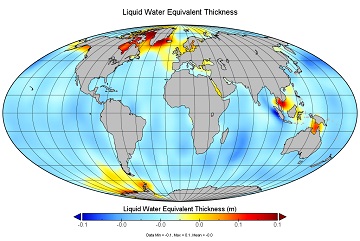
JPL TELLUS GRACE Level-3 Monthly Land Water-Equivalent-Thickness Surface Mass Anomaly Release 6.0 version 04 in netCDF/ASCII/GeoTIFF Formats
The monthly land mass grids contain water mass anomalies given as equivalent water thickness derived from GRACE & GRACE-FO time-variable gravity observations during the... -
CARVE: L4 Gridded Footprints from WRF-STILT model, 2012-2016
This data set provides Weather Research and Forecasting (WRF) Stochastic Time-Inverted Lagrangian Transport (STILT) Footprint data products for particle receptors located at... -
ATom: Data Stream for Modeling the Reactivity of ATom Air Parcels, 2016-2018
This dataset provides Modeling Data Stream (MDS) and Reactivity Data Stream (RDS) products for each of the four ATom campaigns conducted from 2016 to 2018. MDS files contain the... -
Soil Organic Carbon Stock Estimates with Uncertainty across Latin America
This dataset provides 5 x 5 km gridded estimates of soil organic carbon (SOC) across Latin America that were derived from existing point soil characterization data and compiled... -
JPL TELLUS GRACE Level-3 Monthly Ocean Bottom Pressure Anomaly Release 6.0 version 04
The monthly ocean bottom pressure anomaly grids are given as equivalent water thickness changes derived from GRACE & GRACE-FO time-variable gravity observations during the... -
ABoVE: CO2 and CH4 Fluxes and Meteorology at Flux Tower Sites, Alaska, 2015-2017
This dataset provides CO2 and CH4 fluxes and meteorological parameters from five eddy covariance (EC) tower sites located at Barrow (three sites), Atqasuk (ATQ) and Ivotuk... -
ABoVE: Ecosystem Map, Great Slave Lake Area, Northwest Territories, Canada, 1997-2011
This dataset provides an ecosystem type map at 12.5 meter pixel spacing and 0.2 ha minimum mapping unit for the area surrounding Great Slave Lake, Northwest Territories, Canada... -
LBA-ECO LC-14 Biophysical Measurements, Rainfall Exclusion, Tapajos National Forest
This data set reports forest biophysical measurements from a rainfall exclusion experiment conducted at the km 67 Seca Floresta site, Tapajos National Forest, Brazil from 1998... -
RapidScat Level 2B Ocean Wind Vectors in 12.5km Slice Composites Version 1.2
This dataset contains the RapidScat Level 2B 12.5km Version 1.2 science-quality ocean surface wind vectors, which are intended as a replacement and continuation of the Version... -
ABoVE: Vegetation Composition across Fire History Gradients on the Y-K Delta, Alaska
This dataset provides ecological field data that were collected during July 2017 and July 2018 from 43 plots spanning gradients of fire history in the upland tundra of the... -
ABoVE: Wetland Type, Slave River and Peace-Athabasca Deltas, Canada, 2007 and 2017
This dataset provides ecosystem-types for the Slave River Delta (SRD) and Peace-Athabasca Delta (PAD), Canada, for the time periods circa 2007 and circa 2017. The image... -
RapidScat Level 2A Surface Flagged Sigma-0 and Attenuations in 12.5km Swath Grid Version 2.0
This dataset contains the Version 2.0 ISS-RapidScat on Level 2A 12.5 km science data record, which provides surface-flagged sigma-0 in 12.5 km Wind Vector Cells processed using... -
A Compilation of Global Soil Microbial Biomass Carbon, Nitrogen, and Phosphorus Data
This data set provides the concentrations of soil microbial biomass carbon (C), nitrogen (N) and phosphorus (P), soil organic carbon, total nitrogen, and total phosphorus at... -
RapidScat Level 2B Ocean Wind Vectors in 12.5km Slice Composites Version 1.1
This dataset contains the RapidScat Level 2B 12.5km Version 1.1 science-quality ocean surface wind vectors. The Level 2B wind vectors are binned on a 12.5 km Wind Vector Cell... -
LBA-ECO LC-02 Biophysical Measurements of Forests, Acre, Brazil: 1999-2002
This data set provides diameter at breast height (DBH) measurements for 1,063 trees located at the Catuaba Experimental Farm, and 812 trees located in the Humaita Forest... -
BOREAS Agriculture Canada Central Saskatchewan Vector Soils Data, R1
This data set provides soil descriptions for forested areas in the BOREAS southern study area (SSA) in central Saskatchewan, Canada provided by Agriculture Canada. The data... -
SAFARI 2000 Modeled Tropospheric Air Mass Trajectories, Dry Season 2000
The ETA Forecast Trajectory Model was used to produce forecasts of air-parcel trajectories twice a day at three pressure levels over seven sites in Southern Africa for the...

Official websites use .gov
A
.gov website belongs to an official government
organization in the United States.
Secure .gov websites use HTTPS
A
lock (
) or https:// means you’ve safely connected to
the .gov website. Share sensitive information only on official,
secure websites.