
-
SPURS-1 research vessel CTD profile data for N. Atlantic cruises
The SPURS (Salinity Processes in the Upper Ocean Regional Study) project is an oceanographic process study and associated field program that aim to elucidate key mechanisms... -
GEOS-Carb CASA-GFED Monthly Fire Fuel NPP Rh NEE Fluxes 0.5 degree x 0.5 degree V2 (GEOS_CASAGFED_M_FLUX) at GES DISC
This product provides Monthly average Net Primary Production (NPP), heterotrophic respiration (Rh), wildfire emissions (FIRE), and fuel wood burning emissions (FUEL) derived... -
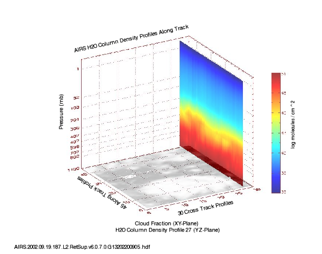
AIRS/Aqua L3 8-day Support Multiday Product (AIRS+AMSU) 1 degree x 1 degree V006 (AIRX3SP8) at GES DISC
The Atmospheric Infrared Sounder (AIRS) is a grating spectrometer (R = 1200) aboard the second Earth Observing System (EOS) polar-orbiting platform, EOS Aqua. In combination... -
Nimbus-7 Coastal Zone Color Scanner (CZCS) Data Regional Data
The Coastal Zone Color Scanner Experiment (CZCS) was the first instrument devoted to the measurement of ocean color and flown on a spacecraft. Although other instruments flown... -
National Oceanographic Partnership Program ARGO profiling floats
Measurements from the NOPP (National Oceanographic Partnership Program) as collected by ARGO profiling floats. -
Gulf of Guinea climate and ocean circulation study (EGEES)
Measurements made in the Gulf of Guinea off of west-central Africa in 2007 as part of the fifth cruise in the EGEE project (Gulf of Guinea climate and ocean circulation study,... -
Gulf of Mexico and East Coast Carbon Cruise (GOMECC)
The Gulf of Mexico and East Coast Carbon Cruise (GOMECC) -
Measurements in Lake Okeechobee, Florida, 1997 - 1999
Optical measurements made in Lake Okeechobee, Florida, between 1997 and 1999 -
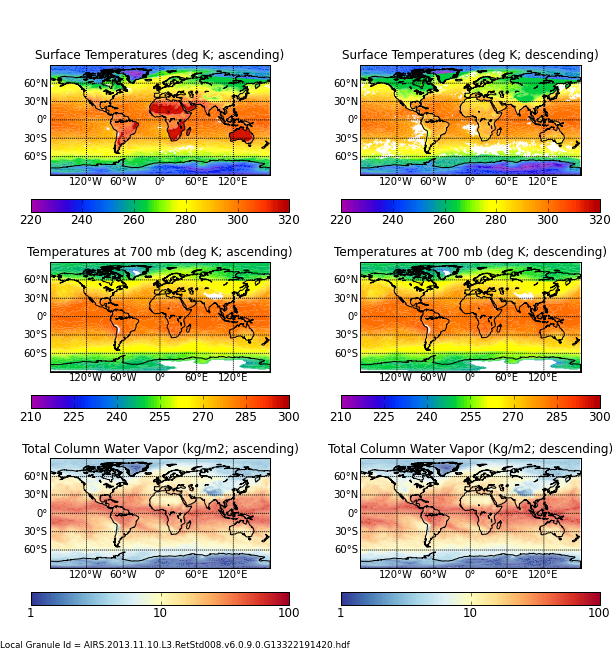
AIRS/Aqua L3 Monthly Standard Physical Retrieval (AIRS-only) 1 degree x 1 degree V006 (AIRS3STM) at GES DISC
The Atmospheric Infrared Sounder (AIRS) is a grating spectrometer (R = 1200) aboard the second Earth Observing System (EOS) polar-orbiting platform, EOS Aqua. In combination... -
GHRSST Level 4 MUR Global Foundation Sea Surface Temperature Analysis (v4.1) NGDA
A Group for High Resolution Sea Surface Temperature (GHRSST) Level 4 sea surface temperature analysis produced as a retrospective dataset (four day latency) and near-real-time... -
NOAA-21 VIIRS Global Mapped Diffuse Attenuation Coefficient for Downwelling Irradiance (KD) - Near Real Time (NRT) Data, version R2022.0
The Ocean Biology DAAC produces near real-time (quicklook) products using the best-available combination of ancillary data from meteorological and ozone data. As such, the... -
GHRSST Level 4 MW_IR_OI Global Foundation Sea Surface Temperature analysis version 5.0 from REMSS NGDA
A Group for High Resolution Sea Surface Temperature (GHRSST) global Level 4 sea surface temperature analysis produced daily on a 0.09-degree grid at Remote Sensing Systems. This... -
Measurements taken in the Aegean and Black seas onboard the R/V Akwanavt
Measurements taken in the Aegean and Black seas during 1997 onboard the R/V Akwanavt. -
Digital Elevation Models for the Global Change Research Wetland, Maryland, USA, 2016
This dataset contains four alternative digital elevation models (DEMs) at 1 m resolution and model performance statistical metrics for the Global Change Research Wetland (GCReW)... -
TOVS GLA MONTHLY GRIDS from NOAA-11 V01 (TOVSAMNH) at GES DISC
This dataset (TOVSAMNH) contains the TIROS Operational Vertical Sounder (TOVS) level 3 geophysical parameters derived using data from NOAA-11 and the physical retrieval method... -
Ocean Surface Current Analyses Real-time (OSCAR) Surface Currents - Final 0.25 Degree (Version 2.0)
Ocean Surface Current Analyses Real-time (OSCAR) is a global surface current database and NASA funded research project. OSCAR ocean mixed layer velocities are calculated from... -
Delta-X: UAVSAR L2 Interferometric Products, MRD, Louisiana, 2021
This dataset contains georeferenced UAVSAR Level 2 (L2) interferometric products for Delta-X flight lines acquired during the spring (2021-03-27 to 2021-04-18) and fall... -
Sounder SIPS: Suomi NPP ATMS Level 3 RAMSES2 Standard Gridded Monthly V3 at GES DISC
This level 3 monthly product is generated from the RAMSES (Retrieval Algorithm for Microwave Sounders in Earth Science) II algorithm.The RAMSES II algorithm is a microwave only... -
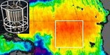
AIRS/Aqua L2 Support Retrieval (AIRS+AMSU) V006 (AIRX2SUP) at GES DISC
The Atmospheric Infrared Sounder (AIRS) is a grating spectrometer (R = 1200) aboard the second Earth Observing System (EOS) polar-orbiting platform, EOS Aqua. In combination...

Official websites use .gov
A
.gov website belongs to an official government
organization in the United States.
Secure .gov websites use HTTPS
A
lock (
) or https:// means you’ve safely connected to
the .gov website. Share sensitive information only on official,
secure websites.