

GHRSST Level 4 MUR Global Foundation Sea Surface Temperature Analysis (v4.1)
Access & Use Information
Downloads & Resources
-
Google Scholar search resultsHTML
Search results for publications that cite this dataset by its DOI.
-
View this dataset's data recipesHTML
Python Subsetting Script
-
View documentation related to this datasetHTML
Group for High Resolution Sea Surface Temperature Information
-
The dataset's project home pageHTML
Homepage for the NASA MEaSUREs projects
-
View this dataset's publicationsHTML
Chin T.M., Milliff R.F., Large W.G. (1998). Basin-scale, high-wavenumber sea...
-
View this dataset's user's guidePDF
Documentation on the GDS version 2 format specification
-
View this dataset's data recipesHTML
Generic data readers
-
View this dataset's publicationsHTML
Chin, Toshio Michael, Jorge Vazquez-Cuervo, and Edward M. Armstrong. A multi-...
-
Use this dataset in a web based toolHTML
MUR formatted in ZARR for Amazon Web Services
-
View documentation related to this datasetHTML
GHRSST Project website
-
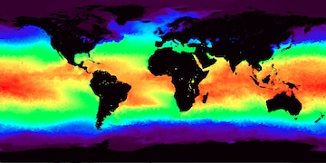
Get a related visualizationJPEG
Thumbnail
-
View this dataset's data citation policyHTML
Data Use and Citation Policy
-
Download this datasetCDF
HTTPS endpoint for data browse and download
-
Download this dataset through Earthdata SearchCDF
Browse granule search results in Earthdata Search
-
View documentation related to this datasetHTML
MUR Project homepage
-
View this dataset's data recipesHTML
Jupyter python notebook to co-locate MUR and MODIS L2P satellite data with...
-
Get a related map visualizationHTML
SOTO (State of the Ocean) Visualization
-
Landing PageLanding Page
References
| https://doi.org/https://doi.org/10.1016/j.rse.2017.07.029 |
Dates
| Metadata Created Date | February 22, 2025 |
|---|---|
| Metadata Updated Date | February 22, 2025 |
Metadata Source
- Data.json Data.json Metadata
Harvested from nasa test json
Additional Metadata
| Resource Type | Dataset |
|---|---|
| Metadata Created Date | February 22, 2025 |
| Metadata Updated Date | February 22, 2025 |
| Publisher | NASA/JPL/PODAAC |
| Maintainer | |
| Identifier | C1996881146-POCLOUD |
| Data First Published | 2014-10-31 |
| Language | en-US |
| Data Last Modified | 2025-02-19 |
| Category | GHRSST, geospatial |
| Public Access Level | public |
| Bureau Code | 026:00 |
| Metadata Context | https://project-open-data.cio.gov/v1.1/schema/catalog.jsonld |
| Schema Version | https://project-open-data.cio.gov/v1.1/schema |
| Catalog Describedby | https://project-open-data.cio.gov/v1.1/schema/catalog.json |
| Harvest Object Id | c0aee49f-5d9d-43bb-a7b8-1f0a2ab6e5a1 |
| Harvest Source Id | a73e0c30-4684-40ef-908e-d22e9e9e5f86 |
| Harvest Source Title | nasa test json |
| Homepage URL | https://doi.org/10.5067/GHGMR-4FJ04 |
| Metadata Type | geospatial |
| Old Spatial | -180.0 -90.0 180.0 90.0 |
| Program Code | 026:001 |
| Related Documents | https://doi.org/https://doi.org/10.1016/j.rse.2017.07.029 |
| Source Datajson Identifier | True |
| Source Hash | 27061ca5519084438471a3b211b13e4ca89ed824101cbd8cd2d16be9d863a9fb |
| Source Schema Version | 1.1 |
| Spatial | |
| Temporal | 2002-05-31T21:00:00Z/2023-03-01T00:00:00Z |
Didn't find what you're looking for? Suggest a dataset here.