
-
TIROS-4 Medium-Resolution Scanning Radiometer Level 1 Final Meteorological Radiation Data V001 (TIROS4L1FMRT) at GES DISC
TIROS-4 Medium-Resolution Scanning Radiometer Level 1 Final Meteorological Radiation Data (FMRT) product contains radiances expressed in five infrared/visible wavelength... -
GPM ATMS on SUOMI-NPP (GPROF) Radiometer Precipitation Profiling L2 1.5 hours 16 km V07 (GPM_2AGPROFNPPATMS) at GES DISC
Version 07 is the current version of the data set. Older versions will no longer be available and have been superseded by Version 07. The 2AGPROF (Goddard Profiling) algorithm... -
OMI/Aura TOMS-Like Ozone and Radiative Cloud Fraction L3 1 day 0.25 degree x 0.25 degree V3 (OMTO3e) at GES DISC
The OMI science team produces this Level-3 Aura/OMI Global TOMS-Like Total Column Ozone gridded product OMTO3e (0.25deg Lat/Lon grids). The OMTO3e product selects the best pixel... -
OCO-2 Level 2 spatially ordered geolocated retrievals screened using the A-band Preprocessor Retrospective Processing V11.2r (OCO2_L2_ABand) at GES DISC
Version 11.2r is the current version of the data set. Older versions will no longer be available and are superseded by Version 11.2r. The Orbiting Carbon Observatory is the... -
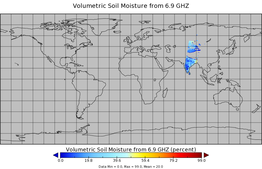
AMSR2/GCOM-W1 downscaled surface soil moisture (LPRM) L2B V001 (LPRM_AMSR2_DS_SOILM2) at GES DISC
AMSR2/GCOM-W1 downscaled surface soil moisture (LPRM) L2B V001 is a Level 2 (swath) data set. Its land surface parameters, surface soil moisture, land surface (skin)... -
TROPICS05 L1B Orbital Geolocated Native-Resolution Brightness Temperatures V0.2
The "Time-Resolved Observations of Precipitation structure and storm Intensity with a Constellation of Smallsats" (TROPICS) mission has a goal of providing nearly all-weather... -
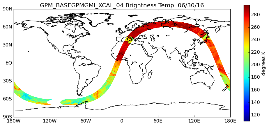
GPM GMI XCAL Common Calibrated Brightness Temperatures L1BASE 1.5 hours 13 km V07 (GPM_BASEGPMGMI_XCAL) at GES DISC
Version 07 is the current version of the data set. Older versions are no longer available and have been superseded by the current version. Consistent rainfall retrievals from... -
Sentinel-5P TROPOMI Methane CH4 1-Orbit L2 7km x 7km V1 (S5P_L2__CH4___) at GES DISC
Starting from August 6th in 2019, Sentinel-5P TROPOMI along-track high spatial resolution (~5.5km at nadir) has been implemented. For data after August 6th of 2019, please check... -
OMPS/NPP L1B NM Radiance EV Calibrated Geolocated Swath Orbital V2 (OMPS_NPP_NMEV_L1B) at GES DISC
The OMPS-NPP L1B NM Radiance EV Calibrated Geolocated Swath Orbital collection contains calibrated and geolocated radiances from 300 to 380 nm measured by the OMPS Nadir-Mapper... -
MLS/Aura Level 3 Bromine Monoxide (BrO) Daily 10degrees Lat Zonal Mean V004 (ML3DZMBRO) at GES DISC
ML3DZMBRO is the EOS Aura Microwave Limb Sounder (MLS) daily zonal mean product for bromine monoxide derived from radiances measured by the 640 GHz radiometer. The data version... -
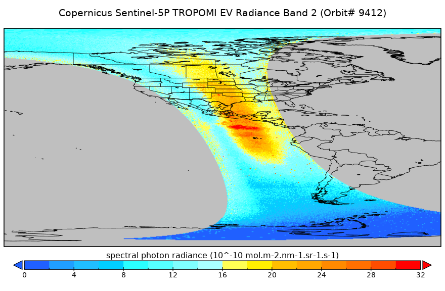
Sentinel-5P TROPOMI Radiance product band 2 (UV detector) L1B 5.5km x 3.5km V2 (S5P_L1B_RA_BD2_HiR) at GES DISC
Starting from August 6th in 2019, Sentinel-5P TROPOMI along-track high spatial resolution (~5.5km at nadir) has been implemented. For data before August 6th of 2019, please... -
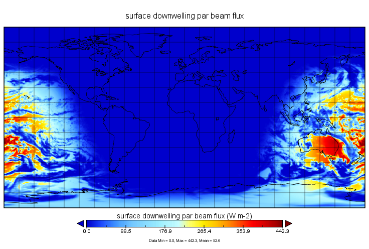
MERRA-2 tavg1_2d_lfo_Nx: 2d,1-Hourly,Time-Averaged,Single-Level,Assimilation,Land Surface Forcings 0.625 x 0.5 degree V5.12.4 (M2T1NXLFO) at GES DISC
M2T1NXLFO (or tavg1_2d_lfo_Nx) is an hourly time-averaged 2-dimensional data collection in Modern-Era Retrospective analysis for Research and Applications version 2 (MERRA-2).... -
OMPS-NPP L2 NM Ozone (O3) Total Column swath orbital
The OMPS-NPP L2 NM Ozone (O3) Total Column swath orbital product provides total ozone measurements from the Ozone Mapping and Profiling Suite (OMPS) Nadir-Mapper (NM) instrument... -
GPM PR on TRMM Reflectivity, Precipitation Statistics, Histograms, at Surface and Fixed Heights, 1 month 5x5 and 0.25x0.25 degree V07 (GPM_3PR) at GES DISC
This is the new (GPM-formated) TRMM product. It replaces the old TRMM_3A25,3A26 Version 07 is the current version of the data set. Older versions will no longer be available and... -
GPM SSMI on F10 (GPROF) Climate-based Radiometer Precipitation Profiling L3 1 day 0.25 degree x 0.25 degree V07 (GPM_3GPROFF10SSMI_DAY_CLIM) at GES DISC
Version 7 is the current version of the data set. Older versions will no longer be available and have been superseded by the current version. The "CLIM" products differ from... -
SAMS/Nimbus-7 Level 1 Radiance Data V001 (SAMSN7L1RAT) at GES DISC
SAMSN7L1RAT is the gridded Nimbus-7 Stratospheric and Mesospheric Sounder (SAMS) Level 1 Radiance Data Product. The radiances were selected to derive gas concentrations at the... -
Carbon Monitoring System Flux for Prior Total Carbon L4 V1 (CMSFluxTotalprior) at GES DISC
This dataset provides the Carbon Flux for Prior Total Carbon. The NASA Carbon Monitoring System (CMS) is designed to make significant contributions in characterizing,... -
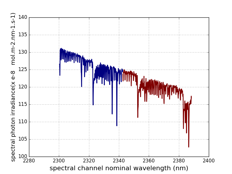
Sentinel-5P TROPOMI Irradiance product SWIR module L1B V2 (S5P_L1B_IR_SIR) at GES DISC
The Copernicus Sentinel-5 Precursor (Sentinel-5P or S5P) satellite mission is one of the European Space Agency's (ESA) new mission family - Sentinels, and it is a joint... -
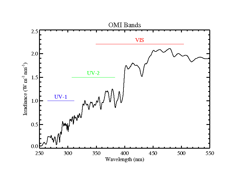
OMI/Aura Level 1B VIS Zoom-in Geolocated Earthshine Radiances 1-orbit L2 Swath 13x12 km V003 (OML1BRVZ) at GES DISC
The Aura Ozone Monitoring Instrument (OMI) Level-1B (L1B) Geo-located Earth View VIS Radiance, Zoom-in-Mode (OML1BRVZ) Version-3 product contains geo-located Earth view spectral... -
OCO-2 Level 2 spatially ordered geolocated retrievals screened using the IMAP-DOAS Preprocessor (IDP) V11.2 (OCO2_L2_IMAPDOAS) at GES DISC
Version 11.2 is the current version of the data set. Older versions will no longer be available and are superseded by Version 11.2. The Orbiting Carbon Observatory is the first...

Official websites use .gov
A
.gov website belongs to an official government
organization in the United States.
Secure .gov websites use HTTPS
A
lock (
) or https:// means you’ve safely connected to
the .gov website. Share sensitive information only on official,
secure websites.