
-
GPM ATMS on NOAA-20 (GPROF) Radiometer Precipitation Profiling L2A 1.5 hours 17 km V07 (GPM_2AGPROFNOAA20ATMS) at GES DISC
Version 07 is the current version of the data set. The 2AGPROF (also known as, GPM GPROF (Level 2)) algorithm retrieves consistent precipitation and related science fields from... -
TROPICS03 L2B Atmospheric Vertical Temperature and Moisture Profiles (AVTP, AVMP) V1.0
The "Time-Resolved Observations of Precipitation structure and storm Intensity with a Constellation of Smallsats" (TROPICS) mission has a goal of providing nearly all-weather... -
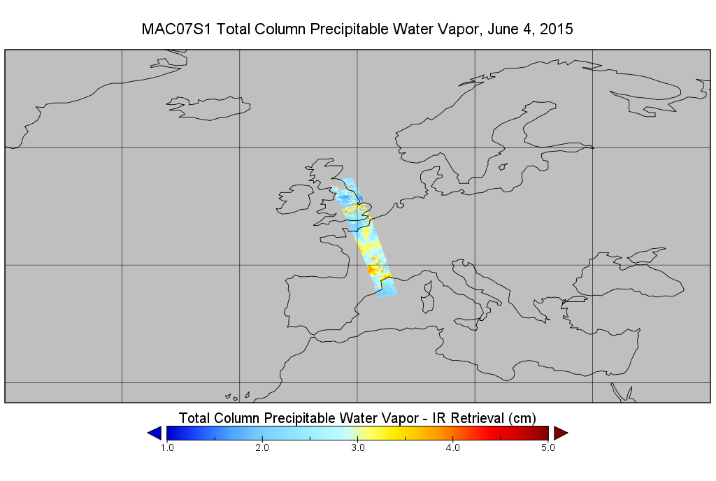
MODIS/Aqua Temp and Water Vapor Profiles 5km 5-Min L2 Wide Swath Subset along CloudSat V002 (MAC07S1) at GES DISC NGDA
This is the wide-swath MODIS/Aqua subset along CloudSat field of view track. The goal of the wide-swath subset is to select and return MODIS data that are within +-100 km across... -
SORCE Combined XPS, SOLSTICE, and SIM Solar Spectral Irradiance 24-Hour Means V001 (SOR3D_COMBINED_001) at GES DISC
The SORCE Combined XPS, SOLSTICE, and SIM Solar Spectral Irradiance 24-Hour Means product consists of daily averages of the solar spetra from 0.1 to 2412 nm. The SORCE... -
OMPS-NPP L2 NP Ozone (O3) Vertical Profile swath orbital V2.9 (OMPS_NPP_NPBUVO3_L2) at GES DISC
The OMPS-NPP L2 NP Ozone (O3) Total Column swath orbital product provides ozone profile retrievals from the Ozone Mapping and Profiling Suite (OMPS) Nadir-Profiler (NP)... -
GPM SSMI on F08 (GPROF) Climate-based Radiometer Precipitation Profiling L3 1 day 0.25 degree x 0.25 degree V07 (GPM_3GPROFF08SSMI_DAY_CLIM) at GES DISC
Version 7 is the current version of the data set. Older versions will no longer be available and have been superseded by the current version. The "CLIM" products differ from... -
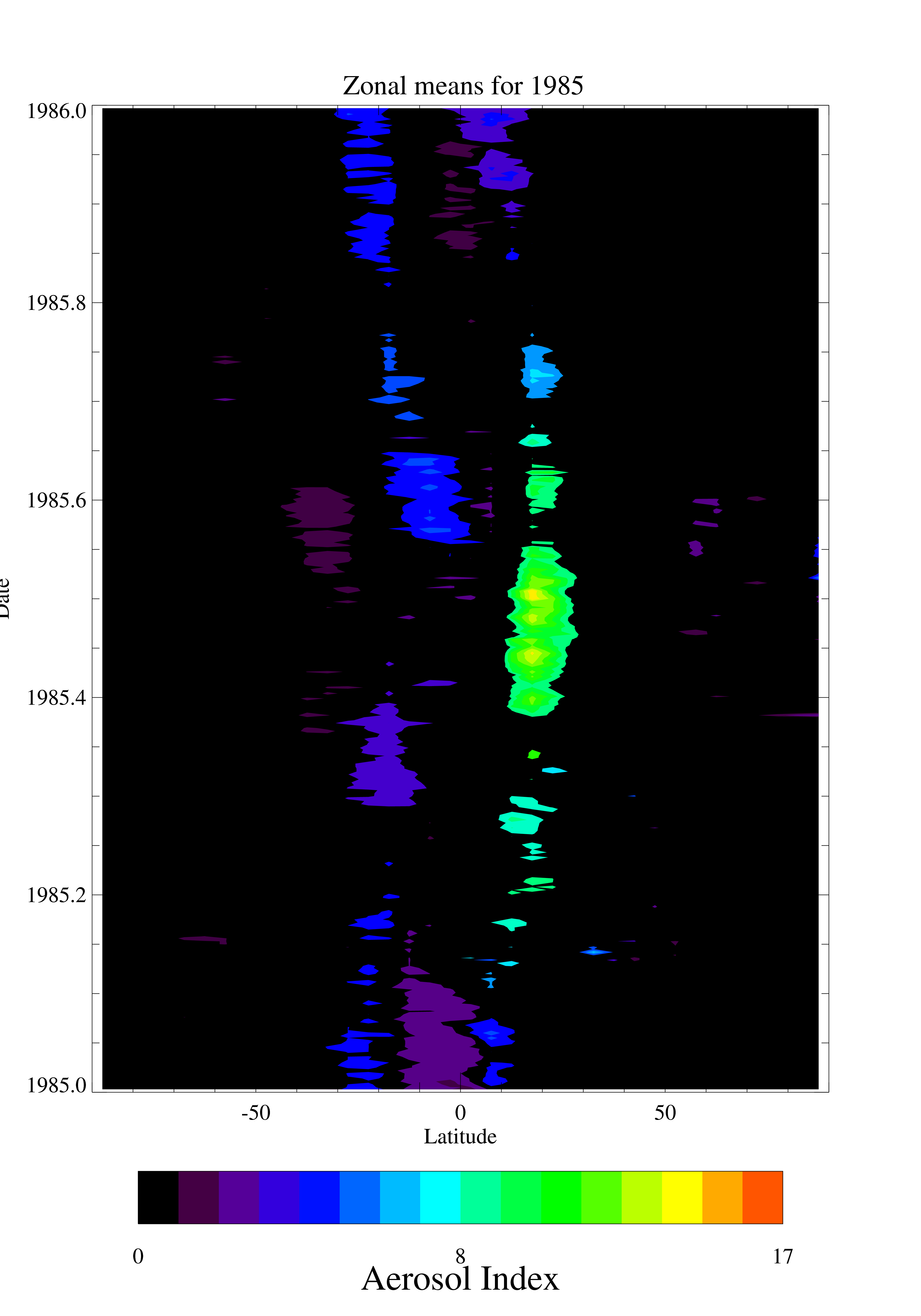
TOMS Nimbus-7 UV Aerosol Index Daily and Monthly Zonal Means V008 (TOMSN7L3zaer) at GES DISC
This Nimbus-7 Total Ozone Mapping Spectrometer (TOMS) version 8 daily zonal means data product contains UV aerosol index values. The data are averaged in 5 degree latitude... -
OMI/Aura NO2 Tropospheric, Stratospheric & Total Columns MINDS Daily L3 Global Gridded 0.25 degree x 0.25 degree V1.1 (OMI_MINDS_NO2d) at GES DISC
As part of the NASA's Making Earth System Data Records for Use in Research Environments (MEaSUREs) program, this project entitled “Multi-Decadal Nitrogen Dioxide and Derived... -
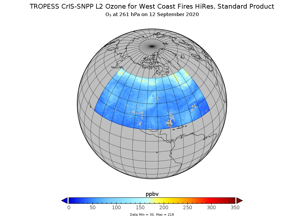
TROPESS CrIS-SNPP L2 Ozone for West Coast Fires HiRes, Standard Product V1 (TRPSDL2O3CRSWCFHI) at GES DISC
The TROPESS CrIS-SNPP L2 Ozone for West Coast Fires HiRes, Standard Product contains the vertical distribution of the retrieved atmospheric state of ozone (O3), formal... -
GPM AMSR-2 on GCOM-W1 (GPROF) Climate-based Radiometer Precipitation Profiling L3 1 day 0.25 degree x 0.25 degree V07 (GPM_3GPROFGCOMW1AMSR2_DAY_CLIM) at GES DISC
Version 07 is the current version of the data set. Older versions will no longer be available and have been superseded by Version 07. The "CLIM" products differ from their... -
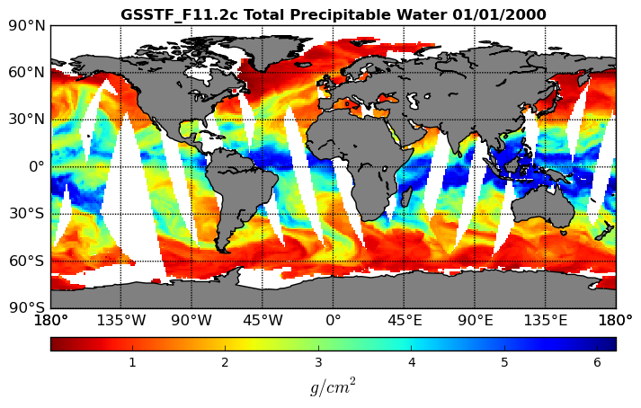
Goddard Satellite-Based Surface Turbulent Fluxes, 0.25 x 0.25 deg, Daily Grid F11 V3 (GSSTF_F11) at GES DISC
These data are part of the Goddard Satellite-based Surface Turbulent Fluxes Version 3 (GSSTF3) Dataset recently produced through a MEaSURES funded project led by Dr. Chung-Lin... -
SORCE SOLSTICE Level 3 Lyman-alpha Irradiance As-Measured Cadence V018 (SOR3SOLS_LA_018) at GES DISC
The SORCE SOLSTICE Level 3 Lyman-alpha Irradiance As-Measured Cadence product consists of all measurements of the Lyman-alpha irradiance from the SOLSTICE instrument. The... -
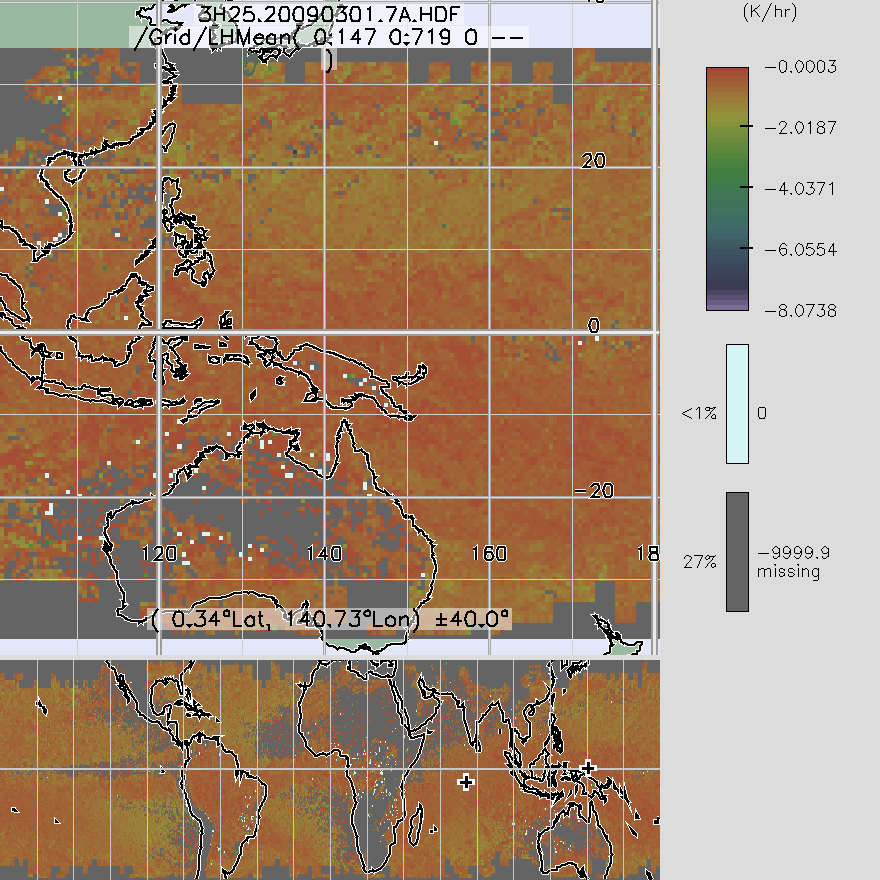
TRMM Precipitation Radar Spectral Latent Heating L3 1 month 0.5 degree x 0.5 degree V7 (TRMM_3H25) at GES DISC
3H25, "Monthly Spectral Latent Heating", produces 0.5 degree x 0.5 degree latent heating, Q1-QR, and Q2 profiles from PR rain -
CAR Eco-3D Vegetation Response to Changing Forcing Factors L1 V1 (CAR_ECO3D_L1C) at GES DISC
This study promotes the understanding of vegetation response to changing forcing factors such as climate, storm frequency, and management practices, and is directly traceable to... -
OMI/Aura Level 2 Sulphur Dioxide (SO2) Trace Gas Column Data 1-Orbit Subset and Collocated Swath along CloudSat V003 (OMSO2_CPR) at GES DISC
This is a CloudSat-collocated subset of the original product OMSO2, for the purposes of the A-Train mission. The goal of the subset is to select and return OMI data that are... -
OCO-3 Level 1A collated, parsed, science or calibration data, Retrospective Processing V11r (OCO3_L1aIn_Pixel) at GES DISC
Version 11r is the current version of the data set. Older versions will no longer be available and are superseded by Version 11r. The Orbiting Carbon Observatory is the first... -
TROPESS CrIS-SNPP L2 for Los Angeles Megacity, Summary Product V1 (TRPSYL2ALLCRSMGLOS) at GES DISC
The TROPESS CrIS-SNPP L2 for Los Angeles Megacity, Summary Product contains the vertical distribution of six retrieved atmospheric gases (CH4, CO, HDO, NH3, O3 and PAN), along... -
MLS/Aura Level 3 Daily Binned Relative Humidity With Respect To Ice (RHI) on Assorted Grids V005 (ML3DBRHI) at GES DISC
ML3DBRHI is the EOS Aura Microwave Limb Sounder (MLS) daily binned on various vertical grids product for relative humidity with respect to ice (RHI) derived from radiances... -
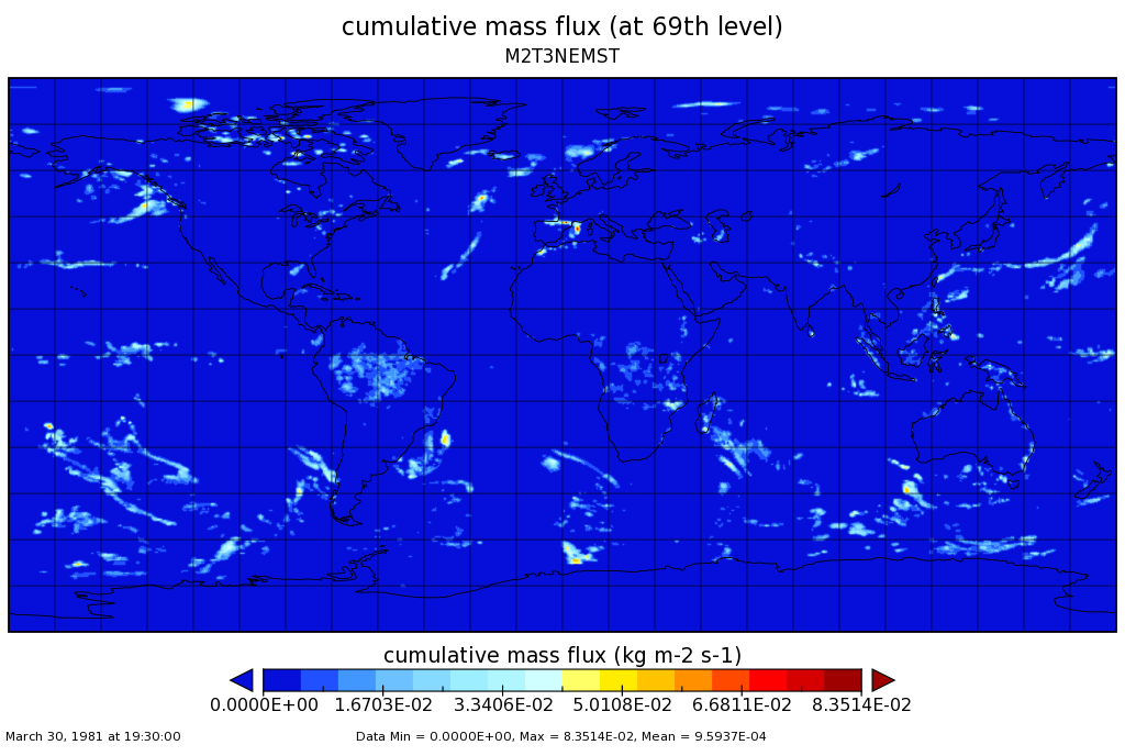
MERRA-2 tavg3_3d_mst_Ne: 3d,3-Hourly,Time-Averaged,Model-Level Edge,Assimilation,Moist Processes Diagnostics 0.625 x 0.5 degree V5.12.4 (M2T3NEMST) at GES DISC
M2T3NEMST (or tavg3_3d_mst_Ne) is a 3-dimensional 3-hourly time-averaged data collection in Modern-Era Retrospective analysis for Research and Applications version 2 (MERRA-2).... -
CAR Discover AQ Air Quality L1 V1 (CAR_DISCOVERAQ_L1C) at GES DISC
DISCOVER-AQ, a NASA Earth Venture program funded mission, stands for Deriving Information on Surface Conditions from Column and Vertically Resolved Observations Relevant to Air...

Official websites use .gov
A
.gov website belongs to an official government
organization in the United States.
Secure .gov websites use HTTPS
A
lock (
) or https:// means you’ve safely connected to
the .gov website. Share sensitive information only on official,
secure websites.