
-
A Compilation of Global Soil Microbial Biomass Carbon, Nitrogen, and Phosphorus Data
This data set provides the concentrations of soil microbial biomass carbon (C), nitrogen (N) and phosphorus (P), soil organic carbon, total nitrogen, and total phosphorus at... -
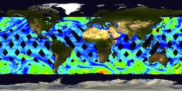
RapidScat Level 2B Ocean Wind Vectors in 12.5km Slice Composites Version 1.1
This dataset contains the RapidScat Level 2B 12.5km Version 1.1 science-quality ocean surface wind vectors. The Level 2B wind vectors are binned on a 12.5 km Wind Vector Cell... -
NASA TechPort
This dataset contains the list of all publicly published NASA projects from within the NASA technology portfolio. In-depth portfolio information, including details for each of... -
Global Landslide Catalog Export
The Global Landslide Catalog (GLC) was developed with the goal of identifying rainfall-triggered landslide events around the world, regardless of size, impacts or location. The... -
LBA-ECO LC-02 Biophysical Measurements of Forests, Acre, Brazil: 1999-2002
This data set provides diameter at breast height (DBH) measurements for 1,063 trees located at the Catuaba Experimental Farm, and 812 trees located in the Humaita Forest... -
BOREAS Agriculture Canada Central Saskatchewan Vector Soils Data, R1
This data set provides soil descriptions for forested areas in the BOREAS southern study area (SSA) in central Saskatchewan, Canada provided by Agriculture Canada. The data... -
SAFARI 2000 Modeled Tropospheric Air Mass Trajectories, Dry Season 2000
The ETA Forecast Trajectory Model was used to produce forecasts of air-parcel trajectories twice a day at three pressure levels over seven sites in Southern Africa for the... -
LBA-ECO LC-07 Validation Overflight for Amazon Mosaics, Video, 1999
This data set presents georeferenced digital video files from Validation Overflight for Amazon Mosaics (VOAM) aerial video surveys as part of the Large-Scale Biosphere-... -
BOREAS Scanning Lidar Imager of Canopies by Echo Recovery (SLICER): Level-3 Data
Scanning Lidar Imager of Canopies by Echo Recovery (SLICER) data were acquired in support of BOReal Ecosystem-Atmosphere Study (BOREAS) at all of the Tower Flux (TF) sites in... -
NACP Site: Tower Meteorology, Flux Observations with Uncertainty, and Ancillary Data
This data set contains meteorological, carbon cycle flux, phenology, and ancillary data measured at 47 eddy covariance flux tower sites across North America. The data were used... -
WISE NEA/COMET DISCOVERY STATISTICS
These tables show discovery statistics for NEAs and comets discovered by NASA's WISE mission - now renamed to NEOWISE. The first small table shows the number of NEAs, PHAs (a... -
NACP MCI: CO2 Flux from Inversion Modeling, Upper Midwest Region, USA, 2007
This data set provides estimates of Net Ecosystem Exchange (NEE) flux for the U.S. Upper Midwest at 0.5-degree resolution for the year 2007. Estimates were produced by two... -
CARVE: L4 Gridded Particle Trajectories for WRF-STILT model, 2012-2016
This data set provides Weather Research and Forecasting (WRF) Stochastic Time-Inverted Lagrangian Transport (STILT) model inputs for particle receptors located at positions... -
X-ray Micro-Tomography (micro-CT)
X-ray micro-tomography (micro-CT) is a non-destructive imaging technique that provides resolution of material microstructures in three dimensions at scales from hundreds of... -
ATom: L2 Measurements from CU High-Resolution Aerosol Mass Spectrometer (HR-AMS)
This dataset provides the atmospheric concentrations of separated ions from inorganic and organic species measured by the High-Resolution Aerosol Mass Spectrometer (HR-AMS)... -
LBA-ECO LC-23 ASTER and MODIS Fire Data Comparison for Brazil: 2003-2004 NGDA
This data set contains data associated with MODIS fire maps generated using two different algorithms and compared against fire maps produced by ASTER. These data relate to a... -
ATom: CAM-chem/CESM2 Model Outputs Along Flight Tracks, 2016-2018
This dataset contains CAM-chem (Community Atmosphere Model with Chemistry) model outputs along ATom flight tracks. CAM-chem is a component of the Community Earth System Model... -
ABoVE: Burn Severity of Soil Organic Matter, Northwest Territories, Canada, 2014-2015
This dataset provides maps at 30-m resolution of landscape surface burn severity (surface litter and soil organic layers) from the 2014-2015 fires in the Northwest Territories... -
A Global Database of Gas Fluxes from Soils after Rewetting or Thawing, Version 1.0
This database contains information compiled from published studies on gas flux from soil following rewetting or thawing. The resulting database includes 222 field and laboratory... -
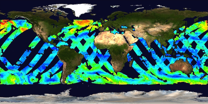
Remote Sensing Systems Radiometer Rain Collocations with JPL RapidScat L2B Swath Grid
This dataset contains the multi-sourced microwave radiometer wind speed, rain and cloud liquid water data collocated to RapidScat Level 2B wind vector cell (WVC) locations. The...

Official websites use .gov
A
.gov website belongs to an official government
organization in the United States.
Secure .gov websites use HTTPS
A
lock (
) or https:// means you’ve safely connected to
the .gov website. Share sensitive information only on official,
secure websites.