

Datasets
-
CARVE: L2 Atmospheric CO2, CO, and CH4 Concentrations, CARVE Tower, Alaska, 2011-2015
This data set provides atmospheric methane (CH4), carbon dioxide (CO2), and carbon monoxide (CO) dry air mole fractions and water vapor mole fractions (H2O) from continuous in... -
ROSETTA-ORBITER 67P RSI 1/2/3 COMET ESCORT 3 1095 V1.0
This is a Rosetta Radio Science data set, collected during the COMET ESCORT 3 phase 2015-07-01 to 2015-10-21. It is a Global Gravity measurement at the comet 67P and covers the... -
ROSETTA-ORBITER 67P RSI 1/2/3 COMET ESCORT 1 0574 V1.0
This is a Rosetta Radio Science data set, collected during the COMET ESCORT 1 phase 2014-11-20 to 2015-03-10. It is a Global Gravity measurement at the comet 67P and covers the... -
Identifying radiation exposure biomarkers from mouse blood transcriptome
Here we present a whole-genome survey of the murine transcriptomic response to physiologically-relevant radiation doses 2 and 8 Gy. There are 18 distinct biological samples... -
GPM GROUND VALIDATION DC-8 NAVIGATION AND HOUSEKEEPING DATA GCPEX V1
The GPM Ground Validation DC-8 Navigation and Housekeeping Data GCPEx dataset, which is composed of two types of files. GCPEx addressed shortcomings in the GPM snowfall... -
MEX EXT 3 SPICAM MARS IR EDR-RAW V2.0
The Mars Express SPICAM level 0B IR data set contains raw measurements from the infrared SPICAM spectrometer collected during the extension 3 MARS phases -
ROSETTA-ORBITER COMET PRELANDING OSINAC 2 EDR data
This data set contains images acquired between 2014-03-18 and 2014-04-06 by the OSIRIS Narrow Angle Camera during the prelanding phase of the Rosetta mission at the comet 67P -
GHRSST L3C global sub-skin Sea Surface Temperature from the Advanced Very High Resolution Radiometer (AVHRR) on Metop satellites (currently Metop-B) (GDS V2) produced by OSI SAF
A global Group for High Resolution Sea Surface Temperature (GHRSST) Level 3 Collated (L3C) dataset derived from the Advanced Very High Resolution Radiometer (AVHRR) on the... -
Academy of Program/Project & Engineering Leadership ASK Magazine Past Issues
Academy of Program/Project & Engineering Leadership's ASK Magazine archive. -
MEaSUREs ITS_LIVE Antarctic Quarterly 1920 m Ice Shelf Height Change and Basal Melt Rates, 1992-2017 V001
This ITS_LIVE data set, part of the Making Earth System Data Records for Use in Research Environments (MEaSUREs) Program, includes quarterly estimates of Antarctic ice shelf... -
ROSETTA-ORBITER 67P RSI 1/2/3 COMET ESCORT 2 0653 V1.0
This is a Rosetta Radio Science data set, collected during the COMET ESCORT 2 phase 2015-03-11 to 2015-06-30. It is a Global Gravity measurement at the comet 67P and covers the... -
VIIRS/NPP BRDF/Albedo WSA at Solar Noon NIR Daily L3 Global 30ArcSec CMG V001
The NASA/NOAA Suomi National Polar-orbiting Partnership (Suomi NPP) Visible Infrared Imaging Radiometer Suite (VIIRS) Bidirectional Reflectance Distribution Function (BRDF) and... -
LBA-ECO TG-06 Vertical Profiles of Atmospheric Trace Gases over the Amazon Basin
This data set contains measurements of atmospheric carbon dioxide (CO2), methane (CH4), carbon monoxide (CO), hydrogen (H2), nitrous oxide (N2O), and sulfur hexafluoride (SF6)... -
ECCO Ocean Mixed Layer Depth - Daily Mean llc90 Grid (Version 4 Release 4)
This dataset provides daily-averaged ocean mixed layer depth on the native Lat-Lon-Cap 90 (LLC90) model grid from the ECCO Version 4 Release 4 (V4r4) ocean and sea-ice state... -
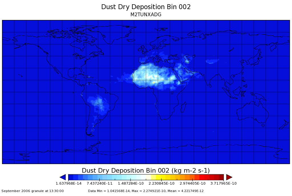
MERRA-2 tavgU_2d_adg_Nx: 2d,diurnal,Time-averaged,Single-Level,Assimilation,Aerosol Diagnostics (extended) 0.625 x 0.5 degree V5.12.4 (M2TUNXADG) at GES DISC
M2TUNXADG (or tavgU_2d_adg_Nx) is a time-averaged 2-dimensional monthly diurnal means data collection in Modern-Era Retrospective analysis for Research and Applications version... -
FIREX-AQ DC-8 In-Situ Cloud Data
FIREXAQ_Cloud_AircraftInSitu_DC8_Data are in-situ cloud measurements collected onboard the DC8 aircraft during FIREX-AQ. This product features data collected by the CDP, CPSPD,... -
Leaf Angle Data (FIFE)
Orientation of leaves of 10 different species -
VIIRS/JPSS1 Surface Reflectance 8-Day L3 Global 500m SIN Grid V002
The 8-day Visible Infrared Imaging Radiometer Suite (VIIRS) (https://lpdaac.usgs.gov/dataset_discovery/viirs) Surface Reflectance (VJ109H1) Version 2 composite product provides...