

AVIRIS-3 L1B Calibrated Radiance, Facility Instrument Collection
Access & Use Information
Public: This dataset is intended for public access and use.
Non-Federal: This dataset is covered by different Terms of Use than Data.gov.
License: No license information was provided.
Downloads & Resources
-
Google Scholar search resultsHTML
Search results for publications that cite this dataset by its DOI.
-
Download this datasetHTML
This link allows direct data access via Earthdata login
-
View documentation related to this datasetHTML
ORNL DAAC Data Set Documentation
-
This dataset's landing pageHTML
Data set Landing Page DOI URL
-
View documentation related to this datasetPDF
AVIRIS-3 L1B Calibrated Radiance, Facility Instrument Collection:...
-
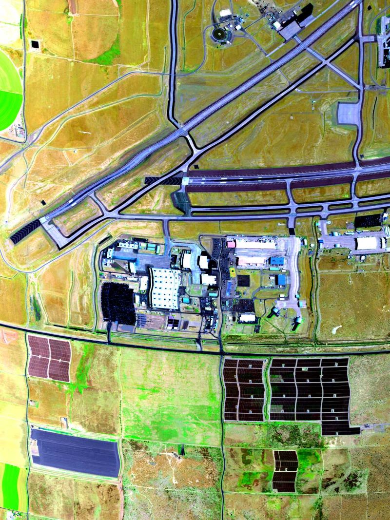
Get a related visualizationJPEG
True color image derived from AVIRIS-3 radiance data on 2023-07-11 over...
-
Landing PageLanding Page
Dates
| Metadata Created Date | February 23, 2025 |
|---|---|
| Metadata Updated Date | February 23, 2025 |
Metadata Source
- Data.json Data.json Metadata
Harvested from nasa test json
Additional Metadata
| Resource Type | Dataset |
|---|---|
| Metadata Created Date | February 23, 2025 |
| Metadata Updated Date | February 23, 2025 |
| Publisher | ORNL_DAAC |
| Maintainer | |
| Identifier | C3236537162-ORNL_CLOUD |
| Data First Published | 2024-09-06 |
| Language | en-US |
| Data Last Modified | 2025-02-19 |
| Category | AVIRIS, geospatial |
| Public Access Level | public |
| Bureau Code | 026:00 |
| Metadata Context | https://project-open-data.cio.gov/v1.1/schema/catalog.jsonld |
| Schema Version | https://project-open-data.cio.gov/v1.1/schema |
| Catalog Describedby | https://project-open-data.cio.gov/v1.1/schema/catalog.json |
| Harvest Object Id | 26918ef9-618e-419c-9121-2d7da7b02b5a |
| Harvest Source Id | a73e0c30-4684-40ef-908e-d22e9e9e5f86 |
| Harvest Source Title | nasa test json |
| Homepage URL | https://doi.org/10.3334/ORNLDAAC/2356 |
| Metadata Type | geospatial |
| Old Spatial | -178.68 16.5 -66.18 72.6 |
| Program Code | 026:001 |
| Source Datajson Identifier | True |
| Source Hash | 9ebe8fe9d5bc0296ba8694b7cffb6b400e6a791aa5d31766339383e2071bd2ac |
| Source Schema Version | 1.1 |
| Spatial | |
| Temporal | 2023-07-05T00:00:00Z/2024-10-14T00:00:00Z |
Didn't find what you're looking for? Suggest a dataset here.