

25 datasets found
-
Dar es Salaam Land Use and Informal Settlement Data Set
NASA Test —
The Dar es Salaam Land Use and Informal Settlement Data Set represents urban land use and consolidation of informal settlements for the years 1982, 1992, 1998, and... -
National Aggregates of Geospatial Data Collection: Population, Landscape, And Climate Estimates, Version 4 (PLACE IV)
NASA Test —
The National Aggregates of Geospatial Data Collection: Population, Landscape, And Climate Estimates, Version 4 (PLACE IV) provides measures of population (head counts)... -
Global Man-made Impervious Surface (GMIS) Dataset From Landsat
NASA Test —
The Global Man-made Impervious Surface (GMIS) Dataset From Landsat consists of global estimates of fractional impervious cover derived from the Global Land Survey... -
Last of the Wild Project, Version 2, 2005 (LWP-2): Global Human Footprint Dataset (Geographic)
NASA Test —
The Global Human Footprint Dataset of the Last of the Wild Project, Version 2, 2005 (LWP-2) is the Human Influence Index (HII) normalized by biome and realm. The HII... -
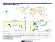
Global One-Eighth Degree Urban Land Extent Projection and Base Year Grids by SSP Scenarios, 2000-2100
NASA Test —
The Global One-Eighth Degree Urban Land Extent Projection and Base Year Grids by SSP Scenarios, 2000-2100 consists of global SSP-consistent spatial urban land fraction... -
Sub-global Scenarios that Extend the Global SSP Narratives: Literature Database, Version 1, 2014-2021
NASA Test —
The Sub-global Scenarios that Extend the Global SSP Narratives: Literature Database, Version 1, 2014-2021 consists of 37 columns of bibliographic data, methodological... -
Global Urban Heat Island (UHI) Data Set, 2013
NASA Test —
The Urban Heat Island (UHI) effect represents the relatively higher temperatures found in urban areas compared to surrounding rural areas owing to higher proportions... -
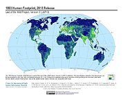
Last of the Wild Project, Version 3 (LWP-3): 2009 Human Footprint, 2018 Release
NASA Test —
The 2009 Human Footprint, 2018 Release provides a global map of the cumulative human pressure on the environment in 2009, at a spatial resolution of ~1 km. The human... -
Last of the Wild Project, Version 1, 2002 (LWP-1): Global Human Footprint Dataset (Geographic)
NASA Test —
The Global Human Footprint Dataset of the Last of the Wild Project, Version 1, 2002 (LWP-1) is the Human Influence Index (HII) normalized by biome and realm. The HII... -
Last of the Wild Project, Version 3 (LWP-3): 1993 Human Footprint, 2018 Release
NASA Test —
The 1993 Human Footprint, 2018 Release provides a global map of the cumulative human pressure on the environment in 1993, at a spatial resolution of ~1 km. The human... -
National Aggregates of Geospatial Data Collection: Population, Landscape, And Climate Estimates (PLACE)
NASA Test —
The National Aggregates of Geospatial Data Collection: Population, Landscape, And Climate Estimates (PLACE) data set contains estimates of national-level aggregations... -
National Aggregates of Geospatial Data Collection: Population, Landscape, And Climate Estimates, Version 3 (PLACE III)
NASA Test —
The National Aggregates of Geospatial Data Collection: Population, Landscape, And Climate Estimates, Version 3 (PLACE III) data set contains estimates of national-... -
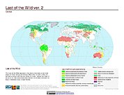
Last of the Wild Project, Version 2, 2005 (LWP-2): Last of the Wild Dataset (IGHP)
NASA Test —
The Last of the Wild Dataset of the Last of the Wild Project, Version 2, 2005 (LWP-2) is derived from the LWP-2 Human Footprint Dataset. The gridded data are... -
Global Summer Land Surface Temperature (LST) Grids, 2013
NASA Test —
The Global Summer Land Surface Temperature (LST) Grids, 2013, represent daytime maximum temperature and nighttime minimum temperature in degree Celsius at a spatial...
25 datasets found