

190 datasets found
-
AIRS/Aqua L3 8-day Support Multiday Product (AIRS+AMSU) 1 degree x 1 degree V006 (AIRX3SP8) at GES DISC
NASA Test —
The Atmospheric Infrared Sounder (AIRS) is a grating spectrometer (R = 1200) aboard the second Earth Observing System (EOS) polar-orbiting platform, EOS Aqua. In... -
FLDAS Noah Land Surface Model L4 Global Monthly 0.1 x 0.1 degree (GDAS and CHIRPS-PRELIM) V001 (FLDAS_NOAH01_CP_GL_M) at GES DISC
NASA Test —
This dataset contains a series of land surface parameters simulated from the Noah 3.6.1 model in the Famine Early Warning Systems Network (FEWS NET) Land Data... -
NLDAS Primary Forcing Data L4 Monthly Climatology 0.125 x 0.125 degree V2.0 (NLDAS_FORA0125_MC) at GES DISC
NASA Test —
This data set contains the monthly climatology data of the primary forcing data for Phase 2 of the North American Land Data Assimilation System (NLDAS-2). The data are... -
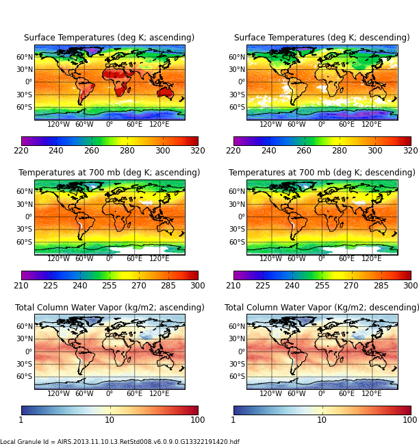
AIRS/Aqua L3 Monthly Standard Physical Retrieval (AIRS-only) 1 degree x 1 degree V006 (AIRS3STM) at GES DISC
NASA Test —
The Atmospheric Infrared Sounder (AIRS) is a grating spectrometer (R = 1200) aboard the second Earth Observing System (EOS) polar-orbiting platform, EOS Aqua. In... -
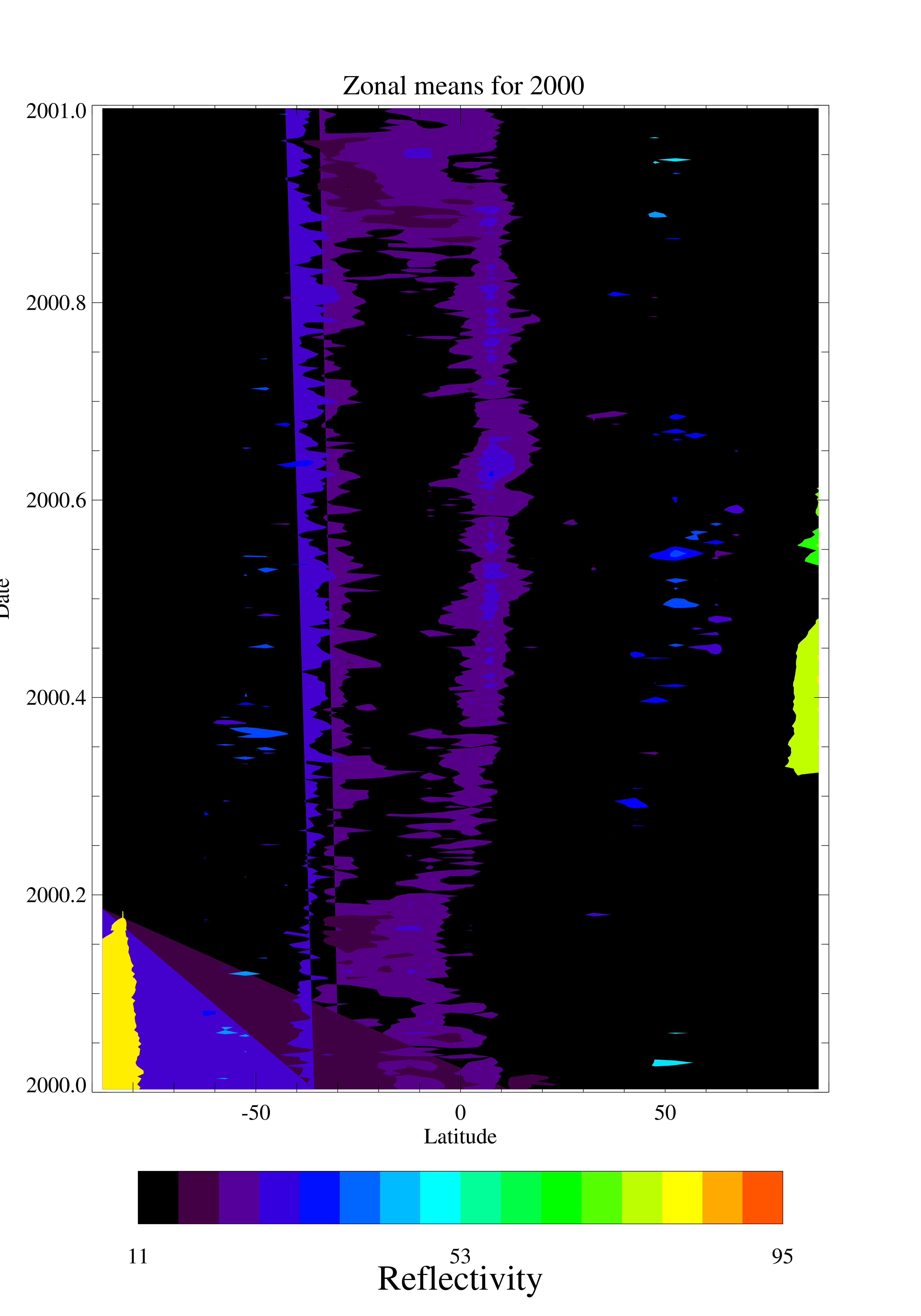
TOMS EP UV Reflectivity Daily and Monthly Zonal Means V008 (TOMSEPL3zref) at GES DISC
NASA Test —
This Earth Probe (EP) Total Ozone Mapping Spectrometer (TOMS) version 8 daily zonal means data product contains Lambertian effective surface reflectivity values... -
TOVS GLA MONTHLY GRIDS from NOAA-11 V01 (TOVSAMNH) at GES DISC
NASA Test —
This dataset (TOVSAMNH) contains the TIROS Operational Vertical Sounder (TOVS) level 3 geophysical parameters derived using data from NOAA-11 and the physical... -
NLDAS Secondary Forcing Data L4 Monthly 0.125 x 0.125 degree V2.0 (NLDAS_FORB0125_M) at GES DISC
NASA Test —
This data set contains the monthly secondary forcing data "File B" for Phase 2 of the North American Land Data Assimilation System (NLDAS-2). The data are in 1/8th... -
NLDAS Noah Land Surface Model L4 Monthly 0.125 x 0.125 degree V2.0 (NLDAS_NOAH0125_M) at GES DISC
NASA Test —
This data set contains fifty-two fields simulated from the Noah land-surface model (LSM) for Phase 2 of the North American Land Data Assimilation System (NLDAS-2). The... -
NLDAS Secondary Forcing Data L4 Hourly 0.125 x 0.125 degree V2.0 (NLDAS_FORB0125_H) at GES DISC
NASA Test —
This data set contains the secondary forcing hourly data "File B" for Phase 2 of the North American Land Data Assimilation System (NLDAS-2). The data are in 1/8th... -
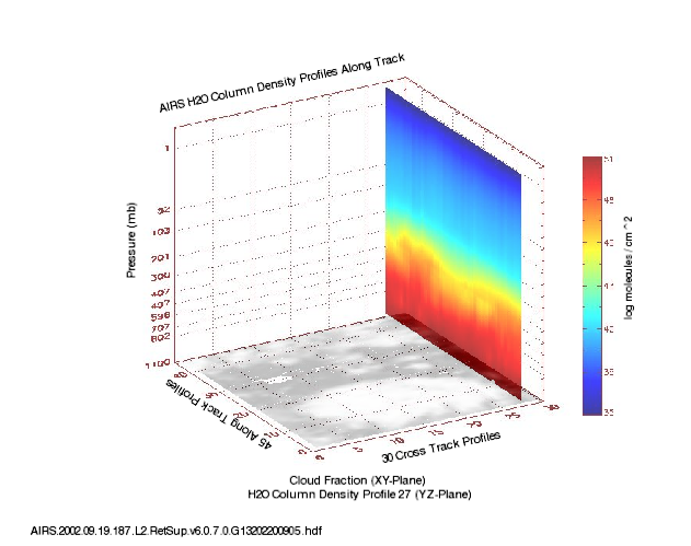
AIRS/Aqua L2 Support Retrieval (AIRS+AMSU) V006 (AIRX2SUP) at GES DISC
NASA Test —
The Atmospheric Infrared Sounder (AIRS) is a grating spectrometer (R = 1200) aboard the second Earth Observing System (EOS) polar-orbiting platform, EOS Aqua. In... -
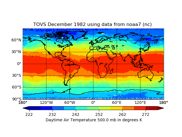
TOVS GLA MONTHLY GRIDS from NOAA-7 02 (TOVSAMNC) at GES DISC
NASA Test —
This dataset (TOVSAMNC) contains the TIROS Operational Vertical Sounder (TOVS) level 3 geophysical parameters derived using data from NOAA-7 and the physical retrieval... -
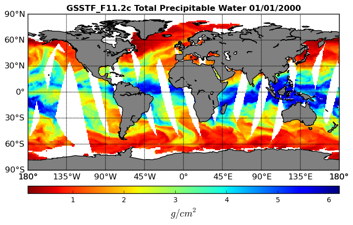
Goddard Satellite-Based Surface Turbulent Fluxes, 0.25 x 0.25 deg, Daily Grid F11 V3 (GSSTF_F11) at GES DISC
NASA Test —
These data are part of the Goddard Satellite-based Surface Turbulent Fluxes Version 3 (GSSTF3) Dataset recently produced through a MEaSURES funded project led by Dr.... -
CAR Eco-3D Vegetation Response to Changing Forcing Factors L1 V1 (CAR_ECO3D_L1C) at GES DISC
NASA Test —
This study promotes the understanding of vegetation response to changing forcing factors such as climate, storm frequency, and management practices, and is directly... -
CAR Discover AQ Air Quality L1 V1 (CAR_DISCOVERAQ_L1C) at GES DISC
NASA Test —
DISCOVER-AQ, a NASA Earth Venture program funded mission, stands for Deriving Information on Surface Conditions from Column and Vertically Resolved Observations... -
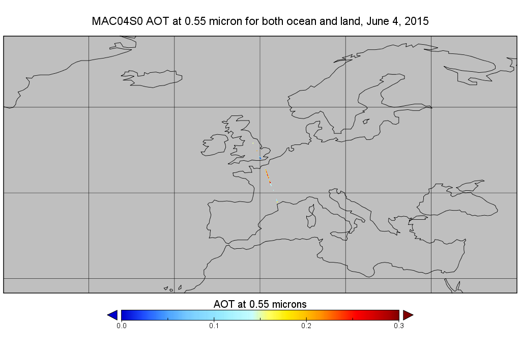
MODIS/Aqua Aerosol 10km 5-Min L2 Narrow Swath Subset along CloudSat V002 (MAC04S0) at GES DISC NGDA
NASA Test —
This is the narrow-swath MODIS/Aqua subset along CloudSat field of view track. The goal of the narrow-swath subset is to select and return MODIS data that are within... -
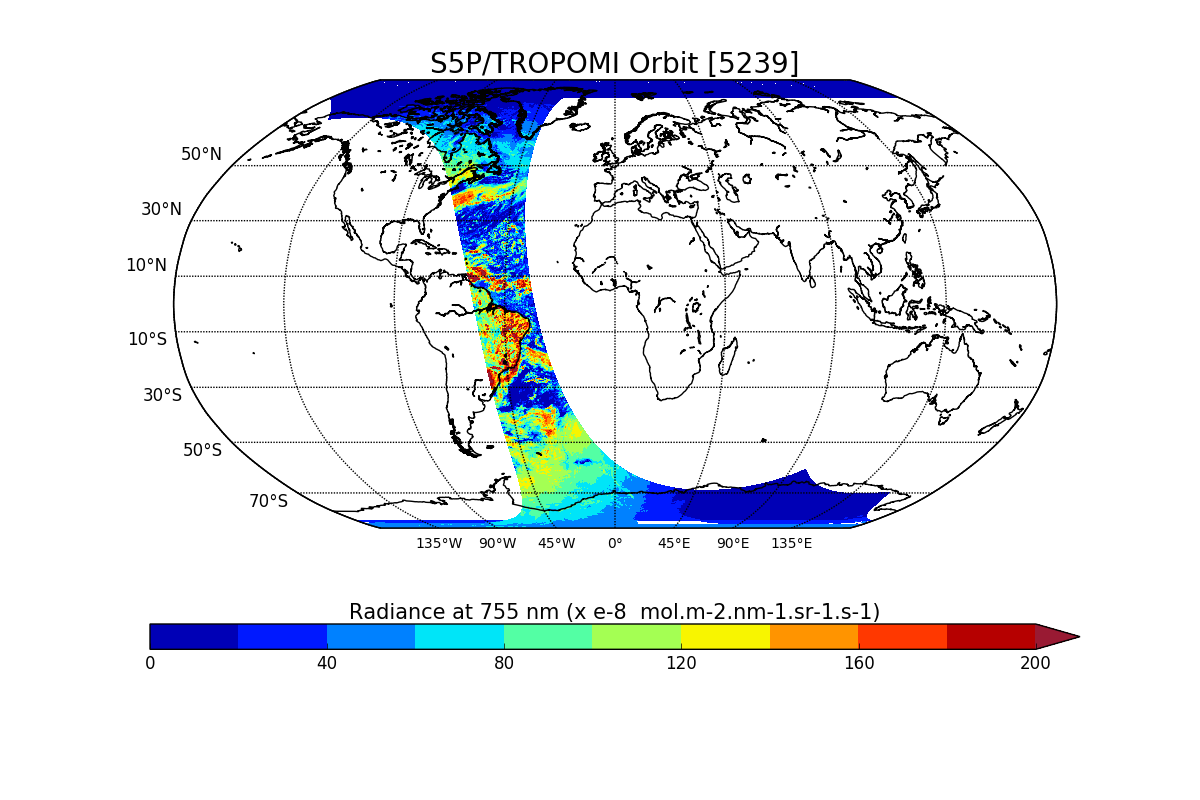
Sentinel-5P TROPOMI Radiance product band 6 (NIR detector) L1B V1 (S5P_L1B_RA_BD6) at GES DISC
NASA Test —
Starting from August 6th in 2019, Sentinel-5P TROPOMI along-track high spatial resolution (~5.5km at nadir) has been implemented. For data after August 6th of 2019,... -
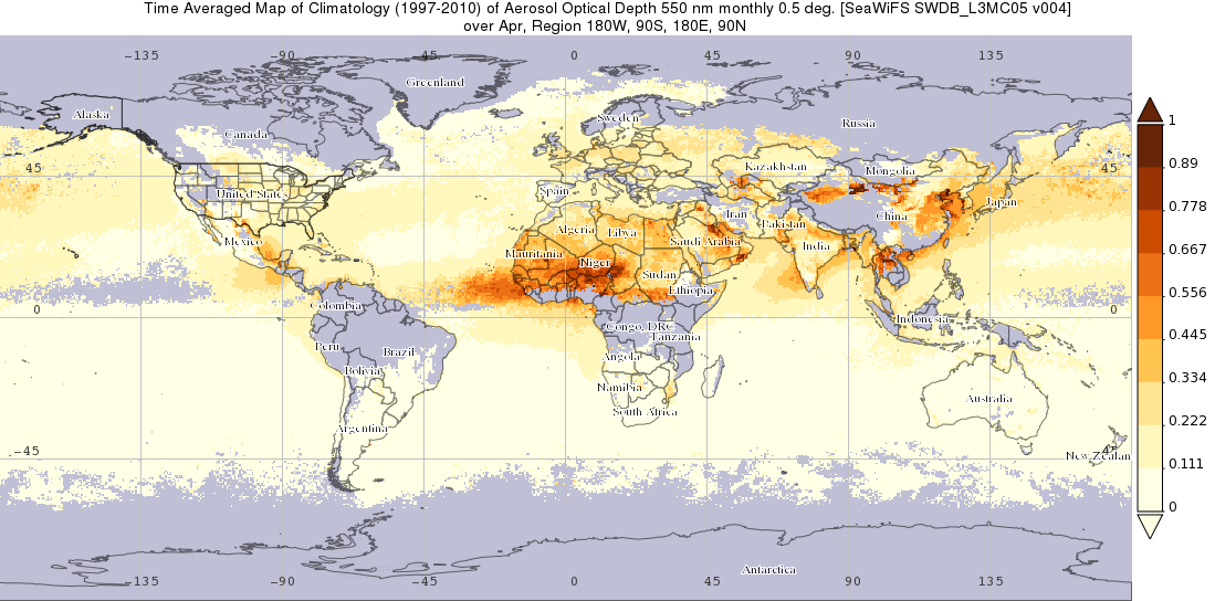
SeaWiFS Deep Blue Aerosol Optical Thickness Monthly Level 3 Climatology Data Gridded at 0.5 Degrees V004 (SWDB_L3MC05) at GES DISC
NASA Test —
The SeaWiFS Deep Blue Level 3 monthly climatology product contains monthly global climatology gridded (0.5 x 0.5 deg) data derived from SeaWiFS Deep Blue Level 3... -
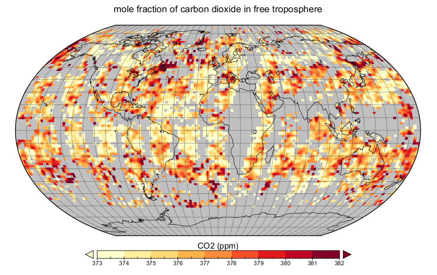
AIRS/Aqua L3 daily CO2 in the free troposphere (AIRS-only) 2.5 degrees x 2 degrees V005 (AIRS3C2D) at GES DISC
NASA Test —
The Atmospheric Infrared Sounder (AIRS) is a grating spectrometer (R = 1200) aboard the second Earth Observing System (EOS) polar-orbiting platform, EOS Aqua. In... -
CAR FIREACE Arctic Ice and Cloud Radiation L1 V1 (CAR_FIREACE_L1C) at GES DISC
NASA Test —
The scientific objectives of FIRE/ACE are to study impact of Arctic clouds on radiation exchange between surface, atmosphere, and space, and the influence of surface... -
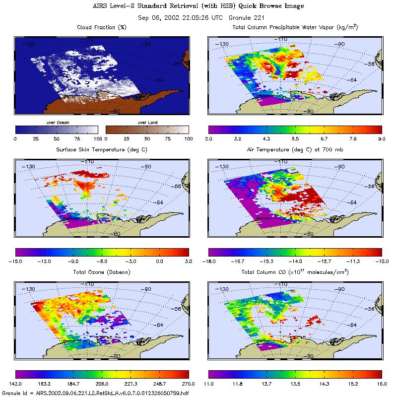
AIRS/Aqua L2 Standard Physical Retrieval (AIRS+AMSU+HSB) V006 (AIRH2RET) at GES DISC
NASA Test —
The Atmospheric Infrared Sounder (AIRS) is a grating spectrometer (R = 1200) aboard the second Earth Observing System (EOS) polar-orbiting platform, EOS Aqua. In...
190 datasets found