
-
VIIRS/JPSS1 Day/Night Band 6-Min L1B Swath 750 m
The VIIRS/JPSS1 Day/Night Band 6-Min L1B Swath 750 m, short-name VJ102DNB is platform-derived single NASA VIIRS panchromatic Day-Night band (DNB) calibrated radiance product.... -
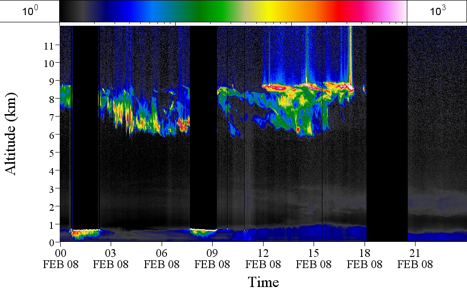
GPM GROUND VALIDATION AEROSOL AND WATER VAPOR LIDAR QUICKLOOKS GCPEX V1
The GPM Ground Validation Aerosol and Water Vapor Lidar Quicklooks GCPEx dataset contains imagery generated from the GPM Cold-season Precipitation Experiment (GCPEx) campaign... -
RapidScat Level 2A Surface Flagged Sigma-0 and Attenuations in 25km Swath Grid Version 2.0
This dataset contains the Version 2.0 ISS-RapidScat Level 2A 25km science data record, which provides surface-flagged sigma-0 in 25km Wind Vector Cells processed using the pulse... -
NASA S-Band Dual Polarimetric Doppler Radar (NPOL) IMPACTS V1
The NASA S-Band Dual Polarimetric (NPOL) Doppler Radar IMPACTS dataset consists of rain rate, reflectivity, Doppler velocity, and other radar measurements obtained from the NPOL... -
Flight Reports EPOCH V1
The Flight Reports EPOCH dataset consists of flight number, purpose of flight, and flight hours logged during the East Pacific Origins and Characteristics of Hurricanes (EPOCH)... -
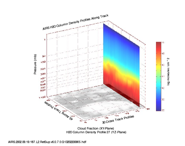
AIRS/Aqua L2 Support Retrieval (AIRS+AMSU) V006 (AIRX2SUP) at GES DISC
The Atmospheric Infrared Sounder (AIRS) is a grating spectrometer (R = 1200) aboard the second Earth Observing System (EOS) polar-orbiting platform, EOS Aqua. In combination... -
SMAP_L1A_RADAR_RECEIVE_ONLY_METADATA_V003
SMAP Level 1A Radar Receive Only Product Metadata Version 3 -
TROPICS03 L2B Atmospheric Vertical Temperature and Moisture Profiles (AVTP, AVMP) V1.0
The "Time-Resolved Observations of Precipitation structure and storm Intensity with a Constellation of Smallsats" (TROPICS) mission has a goal of providing nearly all-weather... -
VIIRS/JPSS1 Imagery Resolution Terrain Corrected Geolocation 6 Min L1 Swath 375m NRT
The VIIRS/JPSS1 Imagery Resolution Terrain Corrected Geolocation 6-Min L1 Swath 375m Near Real Time (NRT) product, short-name VJ103IMG_NRT includes the geolocation fields that... -
IceBridge ARES L1B Geolocated Radar Echo Strength Profiles V001
This data set contains radar echograms acquired by the Arizona Radio-Echo Sounder (ARES) over select glaciers in Alaska. The data are provided in HDF5 formatted files, which... -
AirMSPI verison 6 terrain-projected georegistered radiance product acquired during the NASA ORACLES flight campaign Jul-Oct 2016
AirMSPI_ORACLES_Terrain-projected_Georegistered_Radiance_Data are AirMSPI Terrain-projected georegistered radiance product acquired during the NASA ObseRvations of Aerosols...

Official websites use .gov
A
.gov website belongs to an official government
organization in the United States.
Secure .gov websites use HTTPS
A
lock (
) or https:// means you’ve safely connected to
the .gov website. Share sensitive information only on official,
secure websites.