
-
TROPOMI/Sentinel-5P Near UV Aerosol Optical Depth and Single Scattering Albedo L2 1-Orbit Snapshot 7.5 km x 3 km
As part of the NASA's Making Earth System Data Records for Use in Research Environments (MEaSUREs) program, this projects describes a multi-decadal Fundamental Climate Data... -
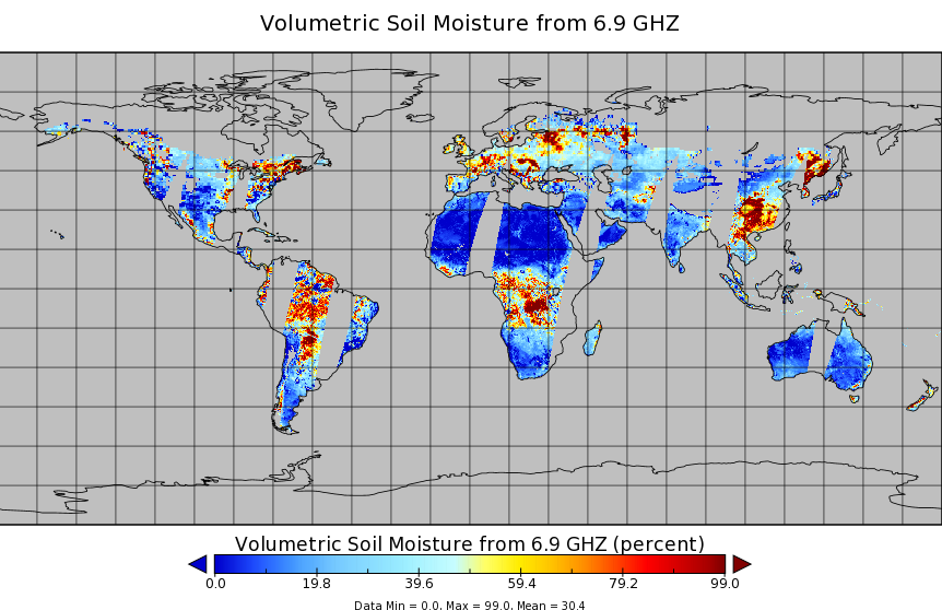
AMSR2/GCOM-W1 surface soil moisture (LPRM) L3 1 day 10 km x 10 km descending V001 (LPRM_AMSR2_DS_D_SOILM3) at GES DISC
AMSR2/GCOM-W1 surface soil moisture (LPRM) L3 1 day 10 km x 10 km descending V001 is a Level 3 (gridded) data set. Its land surface parameters, surface soil moisture, land... -
MLS/Aura Level 2 Bromine Monoxide (BrO) Mixing Ratio V005 (ML2BRO) at GES DISC
ML2BRO is the EOS Aura Microwave Limb Sounder (MLS) standard product for bromine monoxide derived from radiances measured by the 640 GHz radiometer. The data version is 5.0.... -
Carbon Monitoring System Carbon Flux Land Prior L4 V3 (CMSFluxLandPrior)
This dataset provides the Prior for the Land Carbon Flux. The NASA Carbon Monitoring System (CMS) is designed to make significant contributions in characterizing, quantifying,... -
CAR FIREACE Arctic Ice and Cloud Radiation BRDF V2 (CAR_FIREACE_BRDF) at GES DISC
The scientific objectives of FIRE/ACE are to study impact of Arctic clouds on radiation exchange between surface, atmosphere, and space, and the influence of surface... -
MLS/Aura Level 2 Carbon Monoxide (CO) Mixing Ratio V004 (ML2CO) at GES DISC
ML2CO is the EOS Aura Microwave Limb Sounder (MLS) standard product for carbon monoxide derived from radiances measured by the 640 GHz radiometer. The data version is 4.2. Data... -
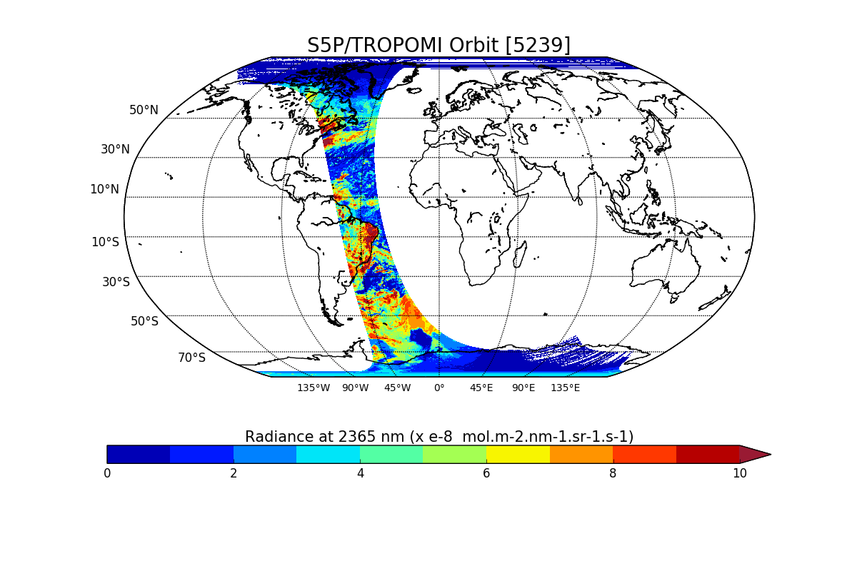
Sentinel-5P TROPOMI Radiance product band 5 (NIR detector) L1B 5.5km x 3.5km V1 (S5P_L1B_RA_BD5_HiR) at GES DISC
Starting from August 6th in 2019, Sentinel-5P TROPOMI along-track high spatial resolution (~5.5km at nadir) has been implemented. For data before August 6th of 2019, please... -
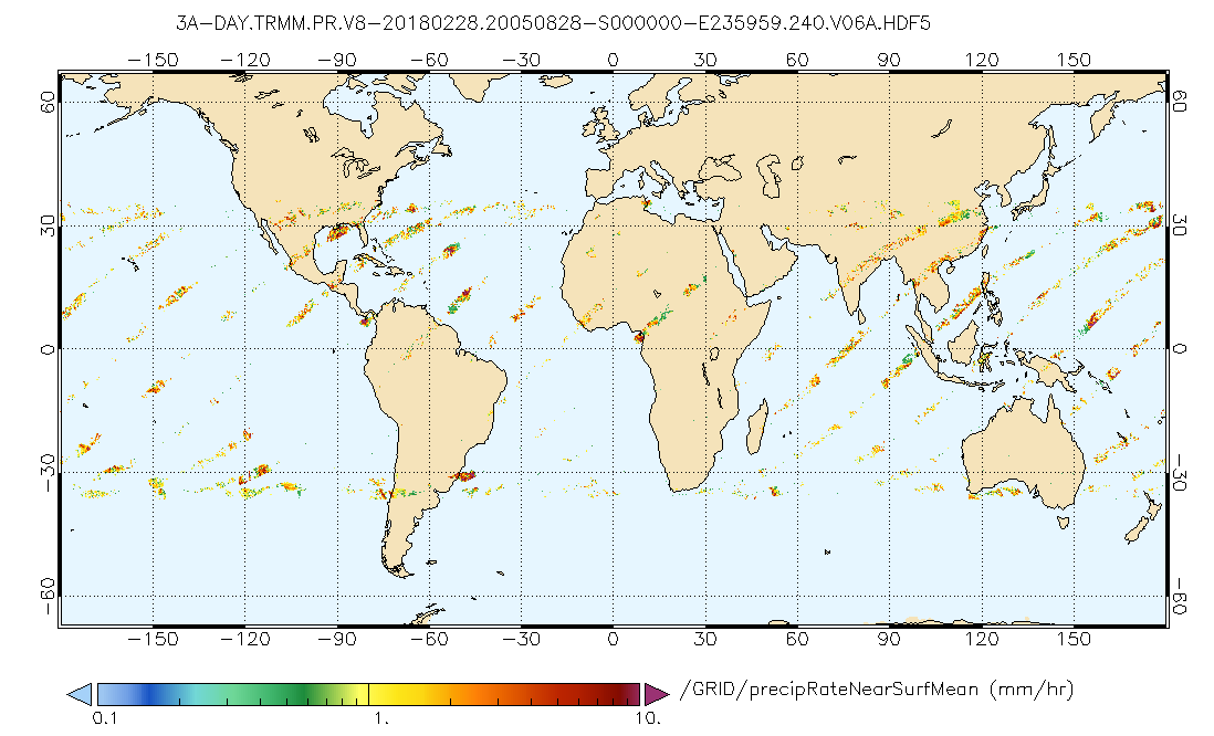
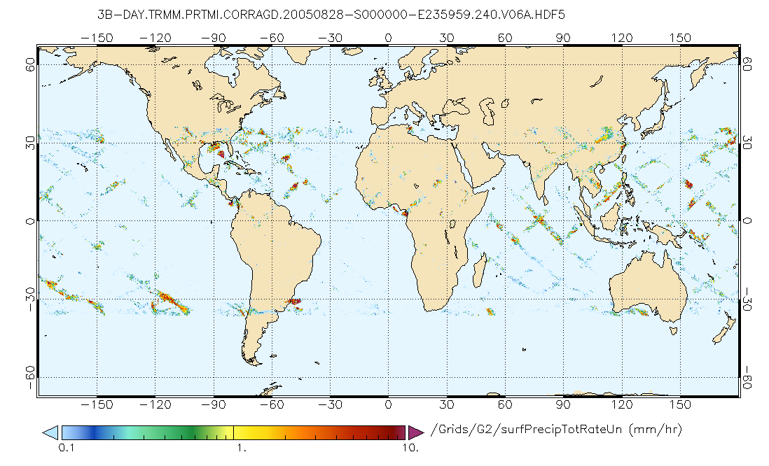
GPM PR on TRMM Precipitation Statistics, at Surface and Fixed Heights 1 day 0.25x0.25 degree V07 (GPM_3PRD) at GES DISC
This a new (GPM-formated) TRMM product. There is no equivalent in the old TRMM suite of products. Version 07 is the current version of the data set. Older versions will no... -
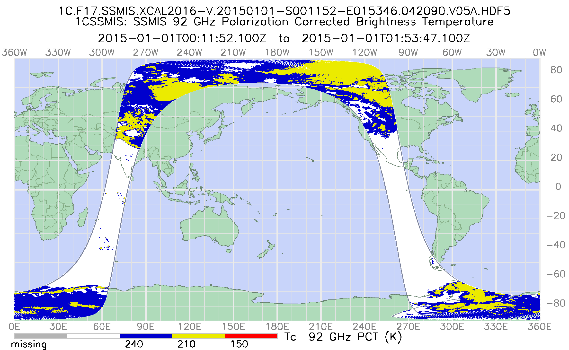
GPM SSMIS on F17 Common Calibrated Brightness Temperatures L1C 1.5 hours 12 km V07 (GPM_1CF17SSMIS) at GES DISC
Version 07 is the current version of the data set. Older versions will no longer be available and have been superseded by Version 07. All 1C products have a common L1C data... -
NASA MEASURES Precipitation Ensemble based on SSM/I DMSP F10 NASA PPS L1C V06 Tbs 1-orbit L2 Swath 12x12km V1 (PRECIP_SSMI_F10) at GES DISC
The data presented in this level 2 orbital product are rain rate estimates expressed as mm/hour determined from brightness temperatures (Tbs) obtained from the Special Sensor... -
Sentinel-5P TROPOMI Radiance product band 8 (SWIR detector) L1B V1 (S5P_L1B_RA_BD8) at GES DISC
Starting from August 6th in 2019, Sentinel-5P TROPOMI along-track high spatial resolution (~5.5km at nadir) has been implemented. For data after August 6th of 2019, please check... -
AIRS/Aqua L3 Monthly Quantization in Physical Units (AIRS+AMSU+HSB) 5 degrees x 5 degrees V006 (AIRH3QPM) at GES DISC
The Atmospheric Infrared Sounder (AIRS) is a grating spectrometer (R = 1200) aboard the second Earth Observing System (EOS) polar-orbiting platform, EOS Aqua. In combination... -
MLS/Aura L1 Orbit/Attitude and Tangent Point Geolocation Data V004 (ML1OA) at GES DISC
ML1OA is the EOS Aura Microwave Limb Sounder (MLS) product containing the level 1 orbit attitude and tangent point geolocation data. The data version is 4.2. Data coverage is... -
MLS/Aura Level 3 Daily Binned Chlorine Monoxide (ClO) Mixing Ratio on Assorted Grids V005 (ML3DBCLO) at GES DISC
ML3DBCLO is the EOS Aura Microwave Limb Sounder (MLS) daily binned on various vertical grids product for chlorine monoxide (ClO) derived from radiances measured primarily by the... -
OMPS-N21 L1G LP Radiance EV Wavelength-Altitude Grid swath orbital 3slit V1.0 (OMPS_N21_LP_L1G_EV) at GES DISC
The OMPS-N21 L1G LP Radiance EV Wavelength-Altitude Grid swath orbital 3slit product contains the calibrated earth-viewing radiances measured by the Ozone Mapping and Profiling... -
GPM PR and TMI on TRMM (Combined Precipitation) L3 1 day 0.25x0.25 degree V07 (GPM_3CMB_TRMM_DAY) at GES DISC
This a new (GPM-formated) TRMM product. There is no equivalent in the old TRMM suite of products. This is the GPM-like formatted TRMM Combined Precipitation (TRMM Ku radar and... -
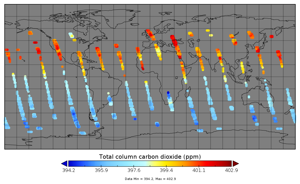
OCO-2 Gridded bias-corrected XCO2, SIF, and other select fields aggregated as Level 3 daily files V4 (OCO2GriddedXCO2_SIF)
Gridded carbon dioxide mole fraction (XCO2) and other select variables created by applying local kriging (also known as optimal interpolation) to daily aggregates of Orbiting... -
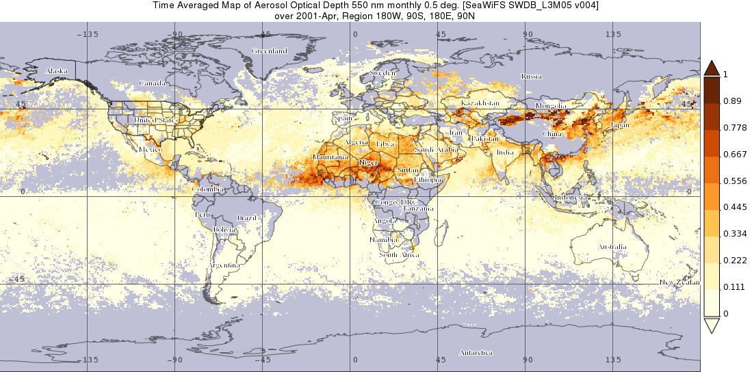
SeaWiFS Deep Blue Aerosol Optical Depth and Angstrom Exponent Monthly Level 3 Data Gridded at 0.5 Degrees V004 (SWDB_L3M05) at GES DISC
The SeaWiFS Deep Blue Level 3 monthly product contains monthly global gridded (0.5 x 0.5 deg) Version 4 data derived from SeaWiFS Deep Blue Level 3 daily gridded data at the... -
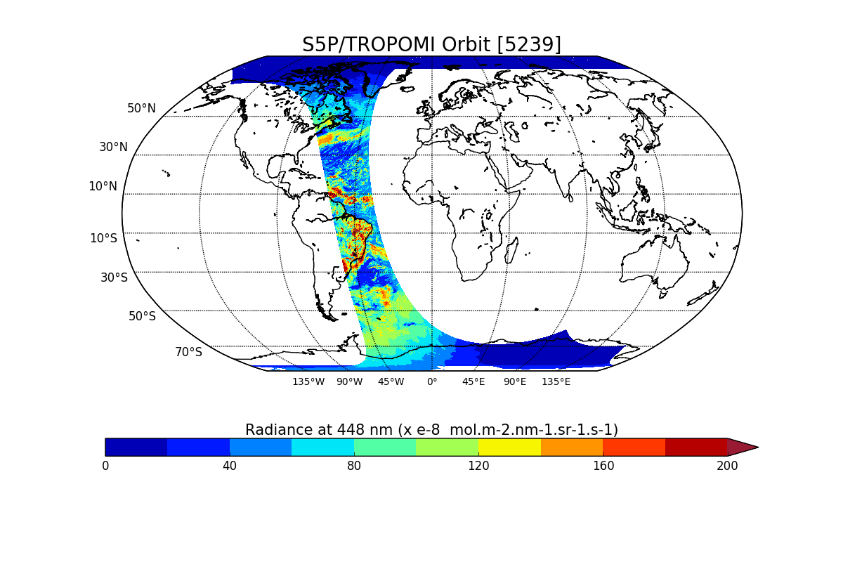
Sentinel-5P TROPOMI Radiance product band 4 (UVIS detector) L1B V1 (S5P_L1B_RA_BD4) at GES DISC
Starting from August 6th in 2019, Sentinel-5P TROPOMI along-track high spatial resolution (~5.5km at nadir) has been implemented. For data after August 6th of 2019, please check... -
GLDAS VIC Land Surface Model L4 monthly 1.0 x 1.0 degree Early Product V2.1 (GLDAS_VIC10_M_EP) at GES DISC
NASA Global Land Data Assimilation System Version 2 (GLDAS-2) has three components: GLDAS-2.0, GLDAS-2.1, and GLDAS-2.2. GLDAS-2.0 is forced entirely with the Princeton...

Official websites use .gov
A
.gov website belongs to an official government
organization in the United States.
Secure .gov websites use HTTPS
A
lock (
) or https:// means you’ve safely connected to
the .gov website. Share sensitive information only on official,
secure websites.