

GPM SSMIS on F17 Common Calibrated Brightness Temperatures L1C 1.5 hours 12 km V07 (GPM_1CF17SSMIS) at GES DISC
Access & Use Information
Downloads & Resources
-
Google Scholar search resultsHTML
Search results for publications that cite this dataset by its DOI.
-
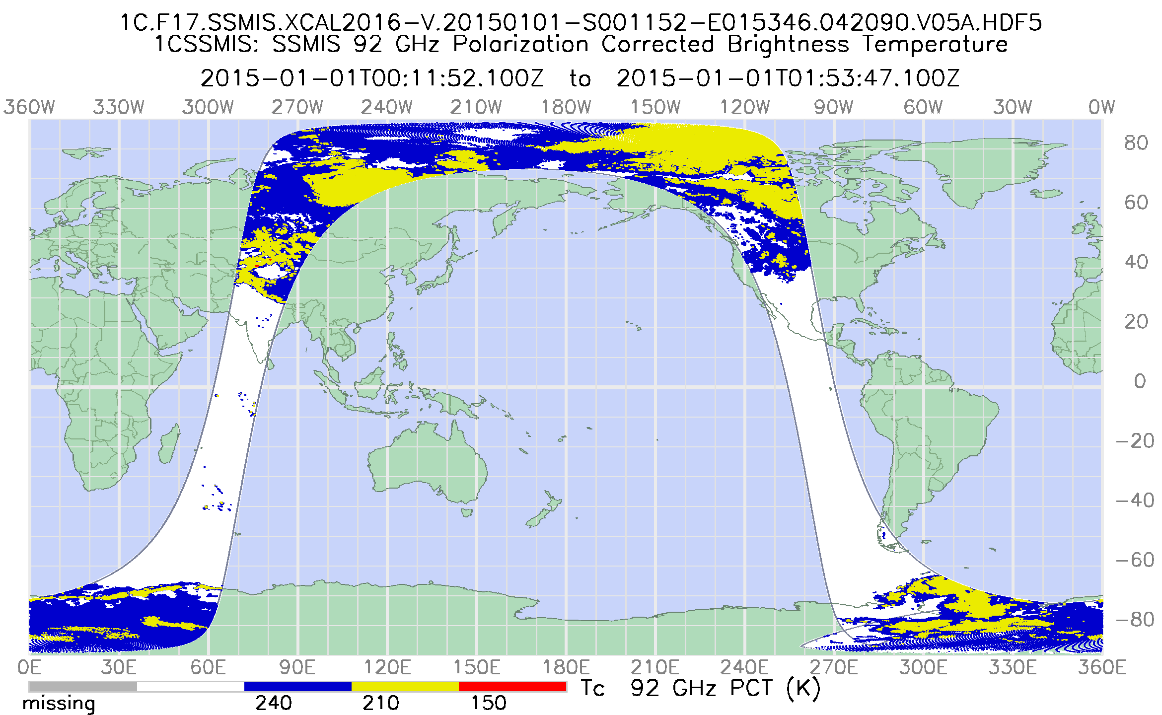
Get a related visualizationPNG
Common Calibrated Brightness Temperature from F17 SSMIS (GPM_1CF17SSMIS)
-
This dataset's landing pageHTML
Access the dataset landing page from the GES DISC website.
-
Download this dataset through a directory mapHTML
Access the data via HTTPS
-
Download this dataset through Earthdata SearchHTML
Use the Earthdata Search to find and retrieve data sets across multiple data...
-
Use OPeNDAP to access the dataset's dataHTML
Access the data via the OPeNDAP protocol.
-
The dataset's project home pageHTML
GPM Project Home Page
-
View this dataset's read me documentPDF
README Document
-
View this dataset's algorithm theoretical...PDF
L1C_ATBD_v1.9_GPMV07.pdf
-
View documentation related to this datasetPDF
Release Notes
-
View this dataset's documented anomaliesHTML
GPM and partner sensors anomalous events
-
View documentation related to this datasetPDF
FILE SPECIFICATION DOCUMENT
-
View documentation related to this datasetHTML
Instrument Description
-
Landing PageLanding Page
References
| https://doi.org/10.1175/JTECH-D-16-0100.1 |
| https://doi.org/10.3390/rs10081306 |
Dates
| Metadata Created Date | February 22, 2025 |
|---|---|
| Metadata Updated Date | February 22, 2025 |
Metadata Source
- Data.json Data.json Metadata
Harvested from nasa test json
Additional Metadata
| Resource Type | Dataset |
|---|---|
| Metadata Created Date | February 22, 2025 |
| Metadata Updated Date | February 22, 2025 |
| Publisher | NASA/GSFC/SED/ESD/GCDC/GESDISC |
| Maintainer | |
| Identifier | C2264132902-GES_DISC |
| Data First Published | 2021-07-21 |
| Language | en-US |
| Data Last Modified | 2025-02-19 |
| Category | GPM, geospatial |
| Public Access Level | public |
| Bureau Code | 026:00 |
| Metadata Context | https://project-open-data.cio.gov/v1.1/schema/catalog.jsonld |
| Schema Version | https://project-open-data.cio.gov/v1.1/schema |
| Catalog Describedby | https://project-open-data.cio.gov/v1.1/schema/catalog.json |
| Harvest Object Id | abfbcd97-21db-405c-9d66-be47213c61eb |
| Harvest Source Id | a73e0c30-4684-40ef-908e-d22e9e9e5f86 |
| Harvest Source Title | nasa test json |
| Homepage URL | https://doi.org/10.5067/GPM/SSMIS/F17/1C/07 |
| Metadata Type | geospatial |
| Old Spatial | -180.0 -90.0 180.0 90.0 |
| Program Code | 026:001 |
| Related Documents | https://doi.org/10.1175/JTECH-D-16-0100.1, https://doi.org/10.3390/rs10081306 |
| Source Datajson Identifier | True |
| Source Hash | 2aca30fdfc94ac4f88355305d490387937a86d761f84495b8f1f3623de25a96f |
| Source Schema Version | 1.1 |
| Spatial | |
| Temporal | 2008-03-19T00:00:00Z/2023-02-28T00:00:00Z |
Didn't find what you're looking for? Suggest a dataset here.