
-
ECCO Sea-Ice Velocity - Daily Mean llc90 Grid (Version 4 Release 4)
This dataset provides daily-averaged sea-ice velocity on the native Lat-Lon-Cap 90 (LLC90) model grid from the ECCO Version 4 Release 4 (V4r4) ocean and sea-ice state estimate.... -
Aquarius Official Release Level 3 Ancillary Reynolds Sea Surface Temperature Standard Mapped Image Ascending Seasonal Data V5.0
Aquarius Level 3 ancillary sea surface temperature (SST) standard mapped image data are the ancillary SST data used in the Aquarius calibration for salinity retrieval. They are... -
Aquarius Official Release Level 3 Sea Surface Spiciness Standard Mapped Image 7-Day Running Mean Data V5.0
Aquarius Level 3 sea surface spiciness standard mapped image data contains gridded 1 degree spatial resolution spice data averaged over daily, 7 day, monthly, and seasonal time... -
GHRSST NOAA/STAR Metop-C AVHRR FRAC ACSPO v2.80 0.02 L3U Dataset (GDS v2)
This L3U (Level 3 Uncollated) dataset contains global daily Sea Surface Temperature (SST) on a 0.02 degree grid resolution. It is produced by the National Oceanic and... -
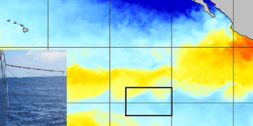
S-MODE Level 1 MASS DoppVis Imagery Version 1
This dataset contains airborne DoppVis imagery from the Sub-Mesoscale Ocean Dynamics Experiment (S-MODE) during the IOP1 campaign conducted approximately 300 km offshore of San... -
SWOT Level 2 Water Mask Raster Image Data Product, Version 1.1
Rasterized water surface elevation and inundation extent in geographically fixed tiles at resolutions of 100 m and 250 m in a Universal Transverse Mercator projection grid.... -
MetOp-A ASCAT Level 2 12.5-km Ocean Surface Wind Vector Climate Data Record Optimized for Coastal Ocean
This dataset represents the first historically reprocessed Level 2 coastal ocean surface wind vector climate data record from the Advanced Scatterometer (ASCAT) on MetOp-A... -
SWOT Level 2 Nadir Altimeter Geophysical Data Record with Waveforms - SGDR
The SWOT Level 2 Nadir Altimeter Geophysical Data Record (GDR) with Waveforms dataset produced by the Surface Water and Ocean Topography (SWOT) mission provides sea surface... -
SPURS-2 Surface Salinity Snake data for the E. Tropical Pacific field campaign R/V Revelle cruises
The SPURS (Salinity Processes in the Upper Ocean Regional Study) project is a NASA-funded oceanographic process study and associated field program that aim to elucidate key... -
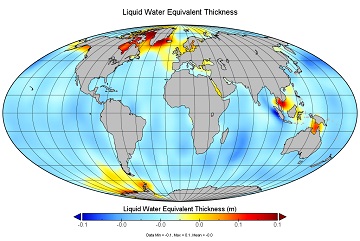
JPL TELLUS GRACE Level-3 Monthly Ocean Bottom Pressure Anomaly Release 6.0 version 04
The monthly ocean bottom pressure anomaly grids are given as equivalent water thickness changes derived from GRACE & GRACE-FO time-variable gravity observations during the... -
ECCO Ocean Velocity - Monthly Mean llc90 Grid (Version 4 Release 4)
This dataset provides monthly-averaged ocean velocity on the native Lat-Lon-Cap 90 (LLC90) model grid from the ECCO Version 4 Release 4 (V4r4) ocean and sea-ice state estimate.... -
Aquarius Official Release Level 3 Rain-flagged Sea Surface Salinity Standard Mapped Image Descending 7-Day Data V5.0
Aquarius Level 3 sea surface salinity (SSS) rain-flagged standard mapped image data contains gridded 1 degree spatial resolution SSS averaged over daily, 7 day, monthly, and... -
Aquarius Official Release Level 3 Rain-flagged Sea Surface Salinity Standard Mapped Image Descending Seasonal Climatology Data V5.0
Aquarius Level 3 sea surface salinity (SSS) rain-flagged standard mapped image data contains gridded 1 degree spatial resolution SSS averaged over daily, 7 day, monthly, and... -
Multi-Mission Optimally Interpolated Sea Surface Salinity Global Dataset V2
This is a level 4 product on a 0.25-degree spatial and 4-day temporal grid. The product is derived from the level 2 swath data of three satellite missions: the Aquarius/SAC-D,... -
Aquarius Official Release Level 3 Sea Surface Spiciness Standard Mapped Image Daily Data V5.0
Aquarius Level 3 sea surface spiciness standard mapped image data contains gridded 1 degree spatial resolution spice data averaged over daily, 7 day, monthly, and seasonal time... -
ECCO Ocean and Sea-Ice Surface Freshwater Fluxes - Monthly Mean 0.5 Degree (Version 4 Release 4)
This dataset contains monthly-averaged ocean and sea-ice surface freshwater fluxes interpolated to a regular 0.5-degree grid from the ECCO Version 4 revision 4 (V4r4) ocean and... -
SPURS-2 Research vessel Meteorological series data for the E. Tropical Pacific field campaign R/V Revelle cruises
The SPURS (Salinity Processes in the Upper Ocean Regional Study) project is a NASA-funded oceanographic process study and associated field program that aim to elucidate key... -
Aquarius Official Release Level 3 Wind Speed Standard Mapped Image Descending Annual Data V5.0
Aquarius Level 3 ocean surface wind speed standard mapped image data contains gridded 1 degree spatial resolution wind speed data averaged over daily, 7 day, monthly, and... -
Aquarius Official Release Level 3 Sea Surface Salinity Standard Mapped Image Monthly Climatology Data V5.0
Aquarius Level 3 sea surface salinity (SSS) standard mapped image data contains gridded 1 degree spatial resolution SSS averaged over daily, 7 day, monthly, and seasonal time... -
ECCO Gent-McWilliams Ocean Bolus Velocity - Monthly Mean llc90 Grid (Version 4 Release 4)
This dataset provides monthly-averaged Gent-McWilliams ocean bolus ocean velocity on the native Lat-Lon-Cap 90 (LLC90) model grid from the ECCO Version 4 Release 4 (V4r4) ocean...

Official websites use .gov
A
.gov website belongs to an official government
organization in the United States.
Secure .gov websites use HTTPS
A
lock (
) or https:// means you’ve safely connected to
the .gov website. Share sensitive information only on official,
secure websites.