
-
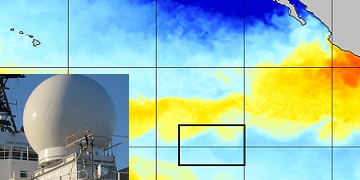
SPURS-2 research vessel along track SEA-POL rain radar imaging data for E. Tropical Pacific R/V Revelle-2 cruise
The SPURS (Salinity Processes in the Upper Ocean Regional Study) project is NASA-funded oceanographic process study and associated field program that aim to elucidate key... -
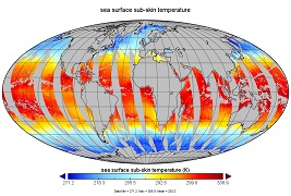
GHRSST L3C global sub-skin Sea Surface Temperature from the Advanced Very High Resolution Radiometer (AVHRR) on Metop satellites (currently Metop-B) (GDS V2) produced by OSI SAF
A global Group for High Resolution Sea Surface Temperature (GHRSST) Level 3 Collated (L3C) dataset derived from the Advanced Very High Resolution Radiometer (AVHRR) on the... -
Aquarius Official Release Level 3 Rain-flagged Sea Surface Salinity Smoothed Standard Mapped Image Monthly Data V5.0
Aquarius Level 3 sea surface salinity (SSS) standard mapped image data contains gridded 1 degree spatial resolution SSS averaged over daily, 7 day, monthly, and seasonal time... -
Jason-1 GDR SSHA version E NetCDF
These Sea Surface Height Anomalies (SSHA) are derived from the Jason-1 Geophysical Data Record (GDR). Jason-1 is an altimetric mission whose instruments make direct observations... -
GHRSST Level 3U Global Subskin Sea Surface Temperature version 8.2 from the Advanced Microwave Scanning Radiometer 2 on the GCOM-W satellite by REMSS
This product contains a “Final” (Refined) Level-3U Sea Surface Temperature (SST) (currently identified by "v8.2" within the file name) for the Group for High Resolution Sea... -
West Atlantic Pre-SWOT Level-4 Hourly MITgcm LLC4320 Native Grid 2km Oceanographic Dataset Version 1.0
This dataset provides a regional multivariate oceanographic state estimate from a global ocean numerical simulation with a focus on the West Atlantic region. The global ocean... -
ECCO Ocean Mixed Layer Depth - Daily Mean 0.5 Degree (Version 4 Release 4)
This dataset contains daily-averaged ocean mixed layer depth interpolated to a regular 0.5-degree grid from the ECCO Version 4 revision 4 (V4r4) ocean and sea-ice state...

Official websites use .gov
A
.gov website belongs to an official government
organization in the United States.
Secure .gov websites use HTTPS
A
lock (
) or https:// means you’ve safely connected to
the .gov website. Share sensitive information only on official,
secure websites.