

GHRSST Level 3U Global Subskin Sea Surface Temperature version 8.2 from the Advanced Microwave Scanning Radiometer 2 on the GCOM-W satellite by REMSS
Access & Use Information
Downloads & Resources
-
Google Scholar search resultsHTML
Search results for publications that cite this dataset by its DOI.
-
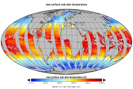
Get a related visualizationJPEG
Thumbnail
-
View documentation related to this datasetHTML
Sea Surface Temperature measurement description.
-
View documentation related to this datasetHTML
Group for High Resolution Sea Surface Temperature Information
-
View this dataset's data recipesHTML
Generic Data Readers
-
View this dataset's user's guidePDF
Documentation on the GDS version 2 format specification
-
View documentation related to this datasetHTML
Full details of the AMSR2
-
View documentation related to this datasetHTML
Samples, Interface Control Document describing file contents, background ppt...
-
View this dataset's data citation policyHTML
Data Use and Citation Policy
-
Download this dataset through a directory mapHTML
HTTPS endpoint for data browse and download
-
Download this dataset through Earthdata SearchHTML
Browse granule search results in Earthdata Search
-
Landing PageLanding Page
References
| https://doi.org/10.1109/IGARSS.2005.1526780 |
Dates
| Metadata Created Date | February 22, 2025 |
|---|---|
| Metadata Updated Date | February 22, 2025 |
Metadata Source
- Data.json Data.json Metadata
Harvested from nasa test json
Additional Metadata
| Resource Type | Dataset |
|---|---|
| Metadata Created Date | February 22, 2025 |
| Metadata Updated Date | February 22, 2025 |
| Publisher | NASA/JPL/PODAAC |
| Maintainer | |
| Identifier | C2600786104-POCLOUD |
| Data First Published | 2017-09-08 |
| Language | en-US |
| Data Last Modified | 2025-02-19 |
| Category | GHRSST, geospatial |
| Public Access Level | public |
| Bureau Code | 026:00 |
| Metadata Context | https://project-open-data.cio.gov/v1.1/schema/catalog.jsonld |
| Schema Version | https://project-open-data.cio.gov/v1.1/schema |
| Catalog Describedby | https://project-open-data.cio.gov/v1.1/schema/catalog.json |
| Harvest Object Id | 9d6878e7-c8e9-4c24-8ce4-d087501ff873 |
| Harvest Source Id | a73e0c30-4684-40ef-908e-d22e9e9e5f86 |
| Harvest Source Title | nasa test json |
| Homepage URL | https://doi.org/10.5067/GHAM2-3UR82 |
| Metadata Type | geospatial |
| Old Spatial | -179.0 -90.0 180.0 90.0 |
| Program Code | 026:001 |
| Related Documents | https://doi.org/10.1109/IGARSS.2005.1526780 |
| Source Datajson Identifier | True |
| Source Hash | 700ec7ac0bc2f148489b617f92bb0882ce549bee30e0c9fffeef0c38a4e2464c |
| Source Schema Version | 1.1 |
| Spatial | |
| Temporal | 2012-07-02T21:00:00Z/2023-05-29T00:00:00Z |
Didn't find what you're looking for? Suggest a dataset here.