
-
First ISCCP Regional Experiment (FIRE) Atlantic Stratocumulus Transition Experiment (ASTEX) Centre Meteorologie Spatiale Weekly Sea SurfaceTemperature Data
The First ISCCP Regional Experiments have been designed to improve data products and cloud/radiation parameterizations used in general circulation models (GCMs). Specifically,... -
NASA MEASURES Precipitation Ensemble based on SSM/I DMSP F14 NASA PPS L1C V06 Tbs 1-orbit L2 Swath 12x12km V1 (PRECIP_SSMI_F14) at GES DISC
The data presented in this level 2 orbital product are rain rate estimates expressed as mm/hour determined from brightness temperatures (Tbs) obtained from the Special Sensor... -
Temperature Profiles: Radiosonde (FIFE)
Temperature & humidity profile data derived from Brutsaert's radiosonde data -
CMS (Carbon Monitoring System) Methane (CH4) Flux for North America 0.5 degree x 0.667 degree V1 (CMS_CH4_FLX_NA) at GES DISC
An error was found in this product; therefore, it has been deleted. Please use the CMS Methane (CH4) Flux for North America Daily product (CMS_CH4_FLX_NAD) in its place. The CMS... -
Timber Measurements (OTTER)
Height, crown width, DBH, and height-to-crown distance collected using variable-radius plot sampling with steel tape and hand-held compass to locate points along transect -
GLDAS Catchment Land Surface Model L4 monthly 1.0 x 1.0 degree V2.1 (GLDAS_CLSM10_M) at GES DISC
NASA Global Land Data Assimilation System Version 2 (GLDAS-2) has three components: GLDAS-2.0, GLDAS-2.1, and GLDAS-2.2. GLDAS-2.0 is forced entirely with the Princeton... -
BOREAS TE-12 Leaf Optical Data for SSA Species
Contains leaf optical properties data collected by the BOREAS TE-12 team. -
Tundra Plant Reflectance, CO2 Exchange, PAM Fluorometry, and Pigments, AK, 2001-2002
This dataset provides measurements at tundra plots collected near Utqiagvik and Atqasuk, AK, including visible-near infrared spectral reflectance, chamber gas exchange... -
SORCE SOLSTICE FUV and MUV Level 3 Solar Spectral Irradiance 0.1nm Res 24-Hour Means V018 (SOR3SOLD_HIGH) at GES DISC
SORCE SOLSTICE FUV and MUV Level 3 Solar Spectral Irradiance 0.1nm Res 24-Hour Means data product (SOR3SOLD_HIGH) is constructed using measurements from the SOLSTICE FUV and MUV... -
NARSTO EPA Supersite (SS) Fresno, Particle-bound Polycyclic Aromatic Compound Data
NARSTO_EPA_SS_FRESNO_PARTICLE_PAC_DATA is North American Research Strategy for Tropospheric Ozone (NARSTO) Environmental Protection Agency (EPA) Supersite (SS) Fresno, Particle-... -
VIIRS/NPP BRDF/Albedo BSA at Solar Noon ShortWave Daily L3 Global 30ArcSec CMG V001
The NASA/NOAA Suomi National Polar-orbiting Partnership (Suomi NPP) Visible Infrared Imaging Radiometer Suite (VIIRS) Bidirectional Reflectance Distribution Function (BRDF) and... -
MISR Level 3 Component Global Land Regional public Product covering a day V002
MI3DLSR_2 is the Multi-angle Imaging SpectroRadiometer (MISR) Level 3 Component Global Land Regional public Product covering a dayversion 2. It contains a daily statistical... -
Gazetteer of Planetary Nomenclature: Uranian System: Umbriel, Titania, Oberon
These images display several of Uranus's moons approved by the International Astronomical Union (IAU). -
BOREAS Follow-On HMet-04 1996-1998 NSA Meteorological Data
As part of the BOREAS Follow-on, an extended period of data collection was supported in the NSA because of the continued efforts at the NSA-OBS site. This data set contains... -
Airborne Multi-angle Imaging SpectroRadiometer (AirMISR) Data from the KONza Validation EXperiment (KONVEX)
The AIRMISR_KONVEX data were acquired during the KONza Validation EXperiment (KONVEX) which occurred 11 - 18 July 1999. The AIRMISR_KONVEX data were obtained on 13 July 1999,... -
MLS/Aura Level 3 Daily Binned Methyl Chloride (CH3Cl) Mixing Ratio on Zonal and Similar Grids V005 (ML3DZCH3CL) at GES DISC
ML3DZCH3CL is the EOS Aura Microwave Limb Sounder (MLS) daily binned on zonal and assorted vertical grids product for methyl chloride (CH3Cl) derived from radiances measured by... -
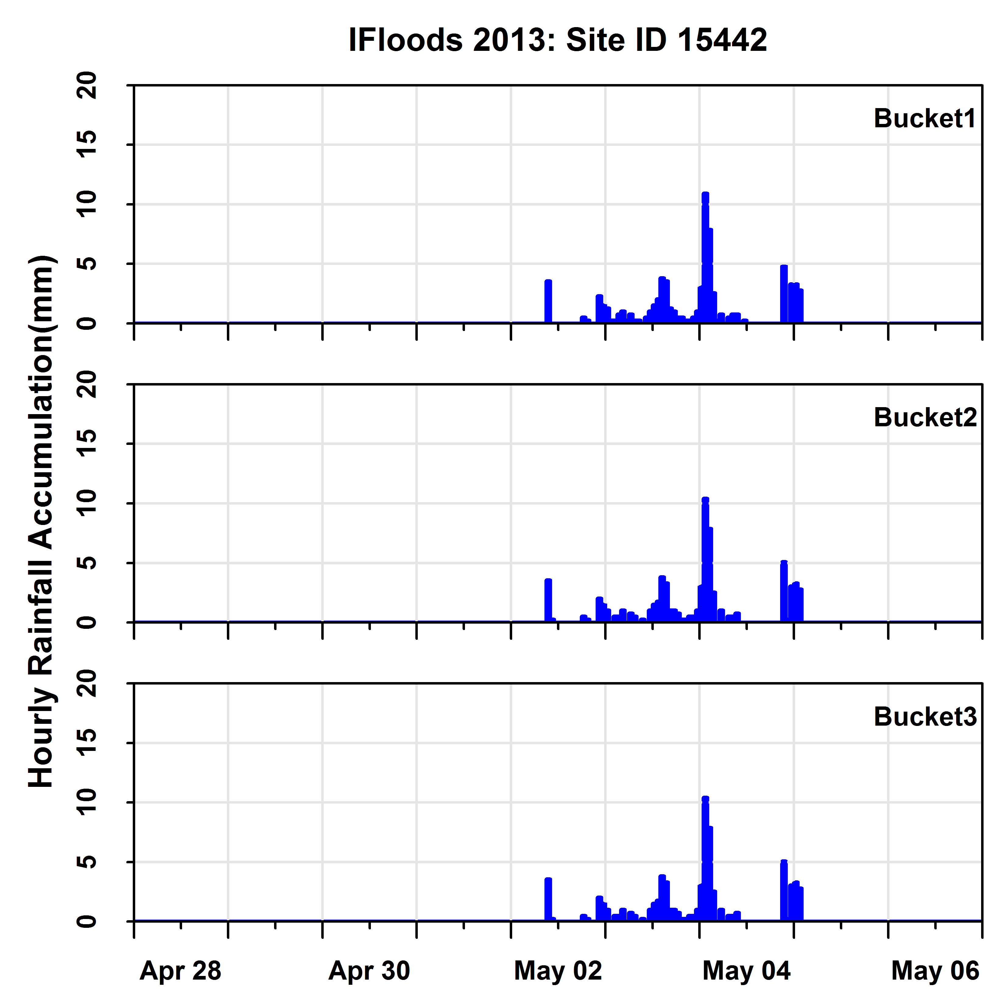
GPM Ground Validation Iowa Flood Center (IFC) Rain Gauges IFloodS V1
The GPM Ground Validation Iowa Flood Center (IFC) Rain Gauges IFloodS dataset was collected during the Iowa Flood Studies (IFloodS) field campaign from April 28, 2013 through... -
Jason-1 GDR SSHA version E NetCDF
These Sea Surface Height Anomalies (SSHA) are derived from the Jason-1 Geophysical Data Record (GDR). Jason-1 is an altimetric mission whose instruments make direct observations...

Official websites use .gov
A
.gov website belongs to an official government
organization in the United States.
Secure .gov websites use HTTPS
A
lock (
) or https:// means you’ve safely connected to
the .gov website. Share sensitive information only on official,
secure websites.