
-
BOREAS Level-1B TIMS Imagery: At Sensor Radiance in BSQ Format
TIMS imagery, along with other aircraft images, was collected to provide spatially extensive information over the primary study areas. The level-1B TIMS images cover the time... -
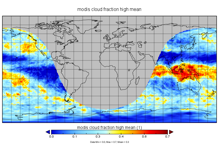
MERRA-2 tavgU_2d_csp_Nx: 2d,diurnal,Time-averaged,Single-Level,Assimilation,COSP Satellite Simulator 0.625 x 0.5 degree V5.12.4 (M2TUNXCSP) at GES DISC
M2TUNXCSP (or tavgU_2d_csp_Nx) is a time-averaged 2-dimensional monthly diurnal means data collection in Modern-Era Retrospective analysis for Research and Applications version... -
TROPICS03 L2A Unified Resolution Brightness Temperatures V1.0
The "Time-Resolved Observations of Precipitation structure and storm Intensity with a Constellation of Smallsats" (TROPICS) mission has a goal of providing nearly all-weather... -
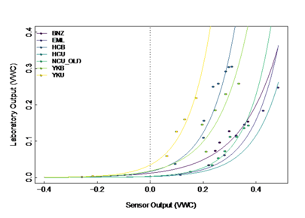
ABoVE: Soil Temperature and VWC at Unburned and Burned Sites Across Alaska, 2016-2023
This dataset provides soil temperature and volumetric water content (VWC) measurements at 15 cm depth collected at 12 selected boreal and tundra sites located across Alaska.... -
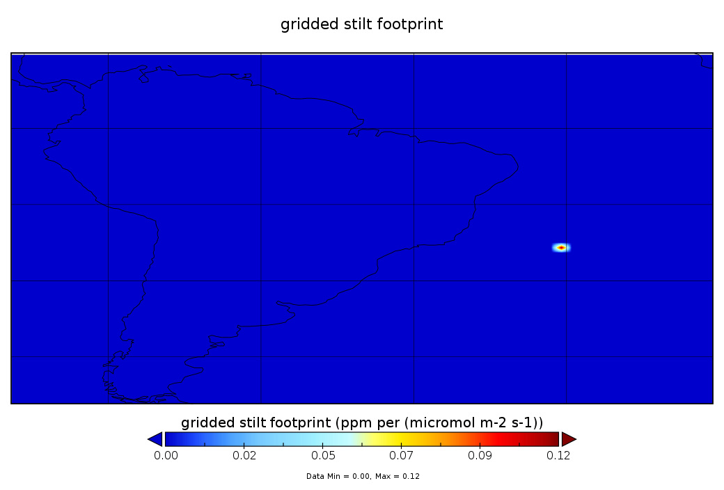
CarbonTracker-Lagrange South America OCO-2 Vertical Profile of Footprints V1 (CMS_CTL_SA_OCO2_FOOTPRINTS)
This data set provides Weather Research and Forecasting (WRF) Stochastic Time-Inverted Lagrangian Transport (STILT) particle trajectory data products for particle receptors co-... -
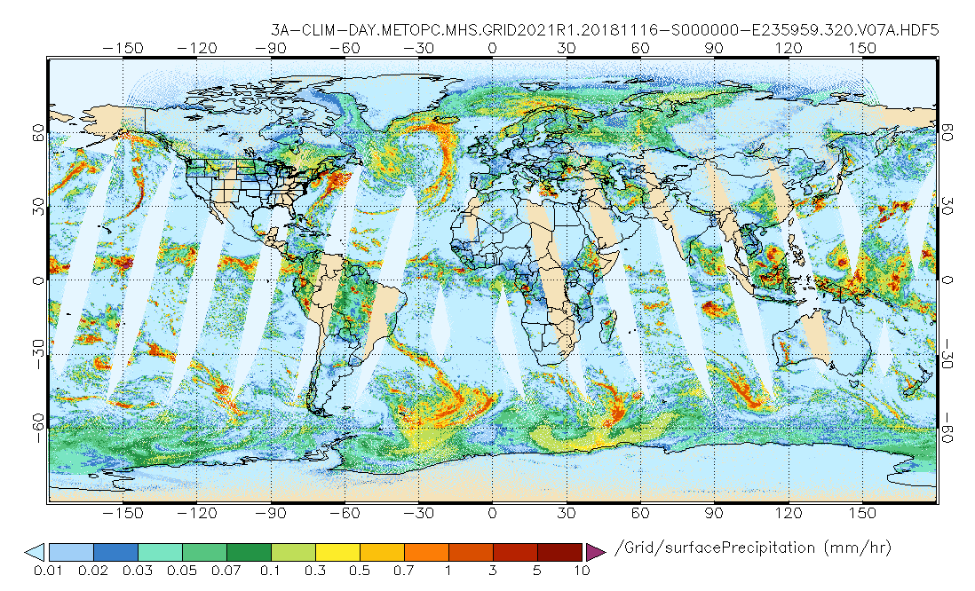
GPM MHS on METOP-C (GPROF) Climate-based Radiometer Precipitation Profiling L3 1 day 0.25 degree x 0.25 degree V07 (GPM_3GPROFMETOPCMHS_DAY_CLIM) at GES DISC
Version 07 is the current version of the data set. Older versions are no longer available and have been superseded by Version 07. The "CLIM" products differ from their "regular"... -
OMPS/NPP L3 NM PCA Sulfur Dioxide (SO2) Total Column Daily Best Pixel Global Gridded 0.25 degree x 0.25 degree V1 (OMPS_NPP_NMSO2_PCA_L3_DAILY) at GES DISC
The OMPS-NPP L3 NM PCA Sulfur Dioxide (SO2) Total Column Daily Best Pixel Global Gridded 0.25 x 0.25 degree product contains sulfur dioxide amounts gridded at 0.25 x 0.25 degree... -
SatCORPS CERES GEO Edition 4 GMS-5 Full Disk Version 2
CER_GEO_Ed4_GMS05_FD_V02 is the Satellite ClOud and Radiation Property retrieval System (SatCORPS) Clouds and the Earth's Radiant Energy System (CERES) Geostationary Satellite... -
BOREAS TE-02 Wood Respiration Data
Contains wood respiration data collected by TE-02. -
MLS/Aura Level 3 Daily Binned Hypochlorous Acid (HOCl) Mixing Ratio on Assorted Grids V004 (ML3DBHOCL) at GES DISC
ML3DBHOCL is the EOS Aura Microwave Limb Sounder (MLS) daily binned on various vertical grids product for hypochlorous acid (HOCl) derived from radiances measured primarily by... -
CAMP2Ex P-3 In-Situ Meteorological and Navigational Data
CAMP2Ex_MetNav_AircraftInSitu_P3_Data are in-situ meteorological and navigational measurements conducted onboard the P-3 aircraft during the Clouds, Aerosol and Monsoon... -
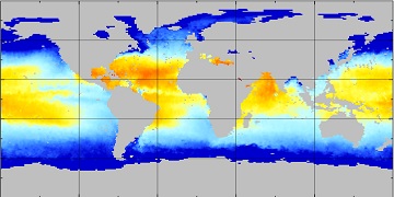
Aquarius Official Release Level 3 Sea Surface Spiciness Standard Mapped Image Mission Cumulative Data V5.0
Aquarius Level 3 sea surface spiciness standard mapped image data contains gridded 1 degree spatial resolution spice data averaged over daily, 7 day, monthly, and seasonal time... -
ABoVE: TVPRM Simulated Net Ecosystem Exchange, Alaskan North Slope, 2008-2017 NGDA
This dataset includes hourly net ecosystem exchange (NEE) simulated by the Tundra Vegetation Photosynthesis and Respiration Model (TVPRM) at 30 km horizontal resolution for the... -
BOREAS TE-06 1994 Soil and Air Temperatures in the NSA
Contains soil temperature data collected by TE-06 during the BOREAS project. -
GHRSST NOAA/STAR ACSPO v2.80 0.02 degree L3S Dataset from mid-Morning LEO Satellites (GDS v2)
NOAA STAR produces two lines of gridded 0.02 degree super-collated L3S LEO sub-skin Sea Surface Temperature (SST) datasets, one from the NOAA afternoon JPSS (L3S_LEO_PM)... -
AIRS/Aqua L1B Near Real Time (NRT) Infrared (IR) quality assurance subset V005 (AIRIBQAP_NRT) at GES DISC
The AIRS Level 1B Near Real Time (NRT) product (AIRIBQAP_NRT_005) differs from the routine product (AIRIBQAP_005) in 2 ways to meet the three hour latency requirements of the... -
BOREAS TF-05 Tower Flux & Meteorological Data
The flux and ancillary data collected at the SSA-OJP tower flux site by the TF-05 group. -
Fast Longwave And SHortwave Fluxes (FLASHflux) Clouds and Radiative Swath (SSF) TERRA-FM1 data in netCDF Version 4B
FLASH_SSF_Terra-FM1-MODIS_Version4B is the Fast Longwave And Shortwave Radiative Fluxes (FLASHFlux) Clouds and Radiative Swath (SSF) TERRA-FM1 data in netCDF Version 4B data... -
COWVR STP-H8 Antenna and Microwave Brightness Temperatures Version 10.0
This data set includes satellite-based observations of calibrated, geo-located antenna temperature and brightness temperatures, along with the sensor telemetry used to derive... -
Measurement of Air Pollution from Satellites (MAPS) Space Radar Laboratory - 2 (SRL2) Carbon Monoxide Second by Second data
MAPS Overview The MAPS experiment measures the global distribution of carbon monoxide (CO) mixing ratios in the free troposphere. Because of MAPS' previous flights on board the...

Official websites use .gov
A
.gov website belongs to an official government
organization in the United States.
Secure .gov websites use HTTPS
A
lock (
) or https:// means you’ve safely connected to
the .gov website. Share sensitive information only on official,
secure websites.