
-
Global Vegetation Greenness (NDVI) from AVHRR GIMMS-3G+, 1981-2022
This dataset holds the Global Inventory Modeling and Mapping Studies-3rd Generation V1.2 (GIMMS-3G+) data for the Normalized Difference Vegetation Index (NDVI). NDVI was based... -
Delta-X: UAVSAR L2 Interferometric Products, MRD, Louisiana, 2021
This dataset contains georeferenced UAVSAR Level 2 (L2) interferometric products for Delta-X flight lines acquired during the spring (2021-03-27 to 2021-04-18) and fall... -
Trends of Thermal, Wetness, and Vegetative Change in the Circumpolar Arctic
This dataset provides estimates of trends in temperature, moisture, and vegetation changes over the circumpolar Arctic. Time series trends were measured by the Theil-Sen slope... -
Global Grid of Probabilities of Urban Expansion to 2030
The Global Grid of Probabilities of Urban Expansion to 2030 presents spatially explicit probabilistic forecasts of global urban land cover change from 2000 to 2030 at a 2.5 arc-... -
SWOT Level 2 Water Mask Pixel Cloud Data Product, Version 2.0
Point cloud of water mask pixels (“pixel cloud”) with geolocated heights, backscatter, geophysical fields, and flags. Point cloud over tile (approx 64x64 km2); half swath (left... -
Sentinel-6A MF Jason-CS L3 P4 Altimeter High Resolution (LR) NTC Ocean Surface Topography (Unfiltered) Version F08
Provides L3 low resolution (LR) non-time critical (NTC; 60-day latency) altimetry from the Poseidon-4 SAR altimeter on the Sentinel-6A Michael Freilich spacecraft, which... -
GRACE OCEAN BOTTOM GEOPOTENTIAL COEFFICIENTS CSR RELEASE 6.0 GAD
FOR EXPERT USE ONLY. This dataset contains estimates of ocean bottom pressure derived from the Gravity Recovery and Climate Experiment (GRACE) mission measurements, produced by... -
SPURS-1 research vessel Thermosalinograph series data for N. Atlantic cruises
The SPURS (Salinity Processes in the Upper Ocean Regional Study) project is an oceanographic process study and associated field program that aim to elucidate key mechanisms... -
Understory Vegetation Biomass from Selected Burned and Unburned sites in Alaska
This dataset provides measurements of vegetation biomass from 11 locations across Alaska during 2016 to 2018. Vegetation was harvested from plots that were located at the end of... -
OMPS-NPP L2 NP Ozone (O3) Vertical Profile swath orbital V2.9 (OMPS_NPP_NPBUVO3_L2) at GES DISC
The OMPS-NPP L2 NP Ozone (O3) Total Column swath orbital product provides ozone profile retrievals from the Ozone Mapping and Profiling Suite (OMPS) Nadir-Profiler (NP)... -
GHRSST NOAA/STAR Metop-B AVHRR FRAC ACSPO v2.80 1km L2P Dataset (GDS v2)
The MetOp First Generation (FG) is a European multi-satellite program jointly established by ESA and EUMETSAT, comprising three satellites, MetOp-A, -B and -C. The primary... -
Groundswell Africa Spatial Population and Migration Projections at One-Eighth Degree According to SSPs and RCPs, 2010-2050
The Groundswell Africa Spatial Population and Migration Projections at One-Eighth Degree According to SSPs and RCPs, 2010-2050 data set provides a baseline population... -
CAR Eco-3D Vegetation Response to Changing Forcing Factors L1 V1 (CAR_ECO3D_L1C) at GES DISC
This study promotes the understanding of vegetation response to changing forcing factors such as climate, storm frequency, and management practices, and is directly traceable to... -
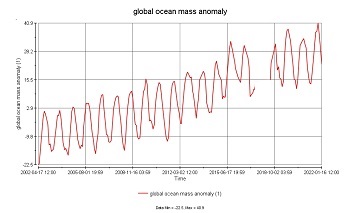
GRACE/GRACE-FO Level-4 Monthly Global Ocean Mass Anomaly version 01 from NASA MEaSUREs HOMaGE project
This data set contains the monthly Global Ocean Mass Anomalies (goma) since 04/2002, as measured by the GRACE and GRACE Follow-On (G/GFO) satellite missions. The data are... -
Northwest Australian Shelf Pre-SWOT Level-4 Hourly MITgcm LLC4320 Native Grid 2km Oceanographic Dataset Version 1.0
This dataset provides a regional multivariate oceanographic state estimate from a global ocean numerical simulation with a focus on the Northwest Australian Shelf region. The... -
VIIRS/JPSS1 BRDF/Albedo Albedo Daily L3 Global 1km SIN Grid V002
The NOAA-20 Visible Infrared Imaging Radiometer Suite (VIIRS) Bidirectional Reflectance Distribution Function (BRDF) and Albedo (VJ143MA3) Version 2 product provides albedo... -
MODIS Terra Level 3 SST Thermal IR Annual 4km Nighttime V2019.0 NGDA
Day and night spatially gridded (L3) global NASA skin sea surface temperature (SST) products from the Moderate-resolution Imaging Spectroradiometer (MODIS) onboard the Terra... -
OCO-3 Level 1A collated, parsed, science or calibration data, Retrospective Processing V11r (OCO3_L1aIn_Pixel) at GES DISC
Version 11r is the current version of the data set. Older versions will no longer be available and are superseded by Version 11r. The Orbiting Carbon Observatory is the first...

Official websites use .gov
A
.gov website belongs to an official government
organization in the United States.
Secure .gov websites use HTTPS
A
lock (
) or https:// means you’ve safely connected to
the .gov website. Share sensitive information only on official,
secure websites.