
-
BOREAS AFM-05 Level-2 Upper Air Network Standard Pressure Level Data
Basic upper-air parameters interpolated at 0.5 kiloPascal increments of atmospheric pressure from the network of upper-air stations during the 1993, 1994, and 1996 field... -
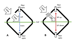
Tundra Plant Leaf-level Spectral Reflectance and Chlorophyll Fluorescence, 2019-2021
This dataset provides leaf-level visible-near infrared spectral reflectance, chlorophyll fluorescence spectra, species, plant functional type (PFT), and chlorophyll content of... -
Plant Biomass/Production/Consump. (FIFE)
Estimates of plant standing crop, plant productions & consumption by herbivores -
Understory Vegetation Biomass from Selected Burned and Unburned sites in Alaska
This dataset provides measurements of vegetation biomass from 11 locations across Alaska during 2016 to 2018. Vegetation was harvested from plots that were located at the end of... -
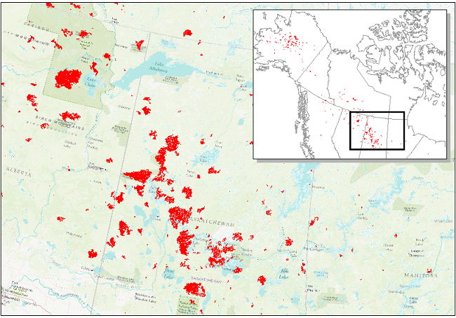
ABoVE: Wildfire Date of Burning within Fire Scars across Alaska and Canada, 2001-2019 NGDA
This dataset provides estimates of wildfire progression represented by date of burning (DoB) within fire scars across Alaska and Canada for the period 2001-2019. Burn scar... -
VEMAP 1: U.S. Climate, 1961-1990
An integrated input data set for ecosystem and vegetation modeling for the conterminous United States: Climate -
LiDAR-Derived Aboveground Biomass and Uncertainty for California Forests, 2005-2014
This dataset provides estimates of aboveground biomass and spatially explicit uncertainty from 53 airborne LiDAR surveys of locations throughout California between 2005 and... -
BOREAS HYD-03 SSA/OLD Aspen DBH Data
The BOREAS HYD-03 team collected several data sets related to the hydrology of forested areas. This data set contains measurements of tree diameter at breast height (DBH) from a... -
Sources of Methane Emissions (Vista-CA), State of California, USA
This dataset provides spatial data products with identified and organized locations of potential methane (CH4) emitting facilities and infrastructure spanning the State of... -
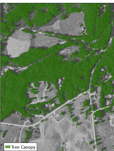
Land Cover and Vegetation Map Collection for Seward Peninsula, Alaska
This data set provides two landcover and vegetation maps for the Seward Peninsula, Alaska. These maps were produced from existing maps, Landsat imagery, and color infrared... -
ISLSCP II Reanalysis Near-Surface Meteorology Data
This data set for the ISLSCP Initiative II data collection provides near surface meteorological variables, fluxes of heat, moisture and momentum at the surface, and land surface... -
BOREAS 1995 HYD-09 Belfort Rain Gauge Data
Contains the Belfort rain gauge data that was collected by the HYD09 group at various locations. -
Satellite Atmos. Correction Coef. (FIFE)
Coefficients required to convert satellite radiances to reflectance/temperature -
SNF Forest Cover by Species/Strata
This is a combined data set of canopy, subcanopy and understory composition by vegetation species and study site ID -
BOREAS TGB-05 CO2, CH4, and CO Chamber Flux Data over the NSA
Contains the TGB-05 CO, CO2, and CH4 flux data for sites in the Boreas Northern Study Area. -
BOREAS RSS-17 Xylem Flux Density Measurements at the SSA-OBS Site
Contains xylem flux density measurements taken by RSS-17 at SSA-OBS. -
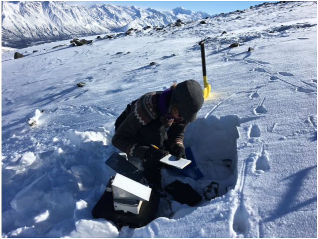
ABoVE: Dall Sheep Track Sinking Depths, Snow Depth, Hardness, and Density, 2017
This dataset contains Dall sheep (Ovis dalli dalli) hoof sinking depths in snow tracks, and snow depth, hardness, and density measurements in snow pits adjacent to the tracks....

Official websites use .gov
A
.gov website belongs to an official government
organization in the United States.
Secure .gov websites use HTTPS
A
lock (
) or https:// means you’ve safely connected to
the .gov website. Share sensitive information only on official,
secure websites.