

Tundra Plant Leaf-level Spectral Reflectance and Chlorophyll Fluorescence, 2019-2021
Access & Use Information
Public: This dataset is intended for public access and use.
Non-Federal: This dataset is covered by different Terms of Use than Data.gov.
License: No license information was provided.
Downloads & Resources
-
Google Scholar search resultsHTML
Search results for publications that cite this dataset by its DOI.
-
Download this datasetHTML
This link allows direct data access via Earthdata login
-
View documentation related to this datasetHTML
ORNL DAAC Data Set Documentation
-
This dataset's landing pageHTML
Data set Landing Page DOI URL
-
View documentation related to this datasetPDF
Tundra Plant Leaf-level Spectral Reflectance and Chlorophyll Fluorescence,...
-
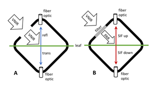
Get a related visualizationPNG
Schematic of FluoWat leaf clip operation for measuring leaf reflectance,...
-
The dataset's project home pageHTML
ABoVE project site
-
Landing PageLanding Page
Dates
| Metadata Created Date | February 21, 2025 |
|---|---|
| Metadata Updated Date | February 21, 2025 |
Metadata Source
- Data.json Data.json Metadata
Harvested from nasa test json
Additional Metadata
| Resource Type | Dataset |
|---|---|
| Metadata Created Date | February 21, 2025 |
| Metadata Updated Date | February 21, 2025 |
| Publisher | ORNL_DAAC |
| Maintainer | |
| Identifier | C2262495547-ORNL_CLOUD |
| Data First Published | 2022-04-30 |
| Language | en-US |
| Data Last Modified | 2025-02-19 |
| Category | ABoVE, geospatial |
| Public Access Level | public |
| Bureau Code | 026:00 |
| Metadata Context | https://project-open-data.cio.gov/v1.1/schema/catalog.jsonld |
| Schema Version | https://project-open-data.cio.gov/v1.1/schema |
| Catalog Describedby | https://project-open-data.cio.gov/v1.1/schema/catalog.json |
| Harvest Object Id | ade0296c-7637-4161-a1cb-112193877240 |
| Harvest Source Id | a73e0c30-4684-40ef-908e-d22e9e9e5f86 |
| Harvest Source Title | nasa test json |
| Homepage URL | https://doi.org/10.3334/ORNLDAAC/2005 |
| Metadata Type | geospatial |
| Old Spatial | -156.6 64.83 -147.81 71.31 |
| Program Code | 026:001 |
| Source Datajson Identifier | True |
| Source Hash | f1f1d4ae9257b33f6b213704c1c47fcdbe73fcb3de7dc69ec34539444620692a |
| Source Schema Version | 1.1 |
| Spatial | |
| Temporal | 2019-07-19T00:00:00Z/2021-09-30T23:59:59Z |
Didn't find what you're looking for? Suggest a dataset here.