
-
NACP MCI: CO2 Flux from Inversion Modeling, Upper Midwest Region, USA, 2007
This data set provides estimates of Net Ecosystem Exchange (NEE) flux for the U.S. Upper Midwest at 0.5-degree resolution for the year 2007. Estimates were produced by two... -
Gazetteer of Planetary Nomenclature
Planetary nomenclature, like terrestrial nomenclature, is used to uniquely identify a feature on the surface of a planet or satellite so that the feature can be easily located,... -
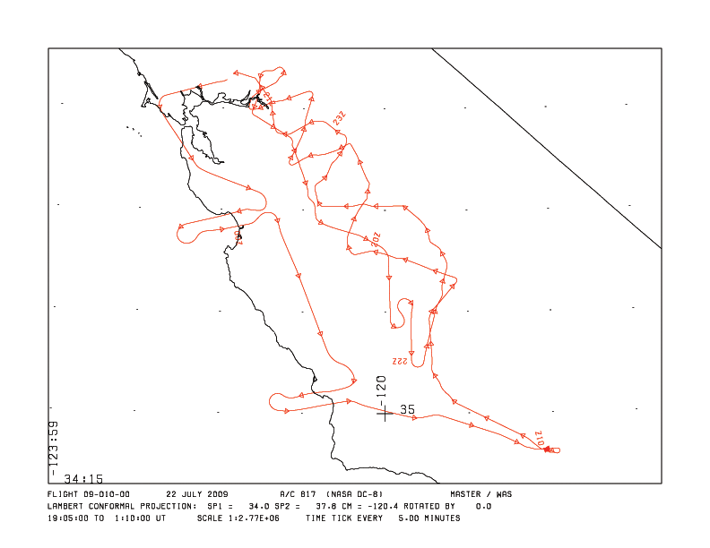
MASTER: HyspIRI Airborne Campaign, California and Nevada, Summer 2016
This dataset includes Level 1B (L1B) and Level 2 (L2) data products from the MODIS/ASTER Airborne Simulator (MASTER) instrument. The data were collected as part of the... -
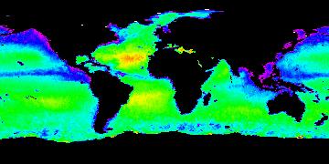
Aquarius Official Release Level 3 Sea Surface Density Standard Mapped Image 28-Day Running Mean Data V5.0
Aquarius Level 3 sea surface density standard mapped image data contains gridded 1 degree spatial resolution derived density averaged over daily, 7 day, monthly, and seasonal... -
Gazetteer of Planetary Nomenclature
Planetary nomenclature, like terrestrial nomenclature, is used to uniquely identify a feature on the surface of a planet or satellite so that the feature can be easily located,... -
Gazetteer of Planetary Nomenclature
Planetary nomenclature, like terrestrial nomenclature, is used to uniquely identify a feature on the surface of a planet or satellite so that the feature can be easily located,... -
Aquarius Official Release Level 3 Sea Surface Salinity Standard Mapped Image 7-Day Data V5.0
Aquarius Level 3 sea surface salinity (SSS) standard mapped image data contains gridded 1 degree spatial resolution SSS averaged over daily, 7 day, monthly, and seasonal time... -
Aquarius Official Release Level 3 Sea Surface Density Standard Mapped Image Ascending Mission Cumulative Data V5.0
Aquarius Level 3 sea surface density standard mapped image data contains gridded 1 degree spatial resolution density data averaged over daily, 7 day, monthly, and seasonal time... -
Aquarius Official Release Level 3 Sea Surface Salinity Smoothed Standard Mapped Image Ascending Monthly Data V5.0
Aquarius Level 3 sea surface salinity (SSS) standard mapped image data contains gridded 1 degree spatial resolution SSS averaged over daily, 7 day, monthly, and seasonal time... -
PHM 2008 Challenge
This dataset describes the degradation of an aircraft engine. The dataset was used for the prognostics challenge competition at the International Conference on Prognostics and... -
Collaborative Testing of Turbulence Models: Incompressible Flow Cases from 1980-81 Data Library
This grouping contains the incompressible-flow cases from the 1980-81 Data Library. -
Aquarius Official Release Level 3 Sea Surface Salinity Standard Mapped Image Ascending 28-Day Running Mean Data V5.0
Aquarius Level 3 sea surface salinity (SSS) standard mapped image data contains gridded 1 degree spatial resolution SSS averaged over daily, 7 day, monthly, and seasonal time... -
Companion dataset for "On the North-South Asymmetry of Co-seismic Ionospheric Disturbances During the 16 September 2015 Illapel M8.3 Earthquake"
The dataset contains outputs from WP-GITM runs and the processed GPS TEC data for the co-seismic ionospheric disturbances during the 16 September 2015 Illapel M8.3 Earthquake. A... -
Aquarius Official Release Level 3 Ancillary Reynolds Sea Surface Temperature Standard Mapped Image Ascending Monthly Climatology Data V5.0
Aquarius Level 3 ancillary sea surface temperature (SST) standard mapped image data are the ancillary SST data used in the Aquarius calibration for salinity retrieval. They are... -
CERES and GEO-Enhanced TOA, Within-Atmosphere and Surface Fluxes, Clouds and Aerosols Daily Terra-Aqua Edition4A NGDA
CER_SYN1deg-Day_Terra-Aqua-MODIS_Edition4A is the Clouds and the Earth's Radiant Energy System (CERES) and geostationary (GEO)-Enhanced Top-of-Atmosphere (TOA), Within-... -
Aquarius Official Release Level 3 Sea Surface Salinity Smoothed Standard Mapped Image Descending Monthly Data V5.0
Aquarius Level 3 sea surface salinity (SSS) standard mapped image data contains gridded 1 degree spatial resolution SSS averaged over daily, 7 day, monthly, and seasonal time... -
Aquarius Official Release Level 3 Sea Surface Spiciness Standard Mapped Image Descending Monthly Data V5.0
Aquarius Level 3 sea surface spiciness standard mapped image data contains gridded 1 degree spatial resolution spice data averaged over daily, 7 day, monthly, and seasonal time... -
CERES MODIS Cloud Retrievals in ISCCP-D2like Format Day Terra FM2 Edition3A NGDA
CER_ISCCP-D2like-Day_Terra-FM2-MODIS_Edition3A is the Clouds and the Earth's Radiant Energy System (CERES) Moderate Resolution Imaging Spectroradiometer (MODIS) Cloud Retrievals... -
Aquarius Official Release Level 3 Sea Surface Density Standard Mapped Image Descending Daily Data V5.0
Aquarius Level 3 sea surface density standard mapped image data contains gridded 1 degree spatial resolution density data averaged over daily, 7 day, monthly, and seasonal time... -
Film Cooling Data
Researchers at NASA GRC conducted an experimental investigation of the flow physics of turbine film cooling by obtaining detailed mean and fluctuating velocity and temperature...

Official websites use .gov
A
.gov website belongs to an official government
organization in the United States.
Secure .gov websites use HTTPS
A
lock (
) or https:// means you’ve safely connected to
the .gov website. Share sensitive information only on official,
secure websites.