

MASTER: HyspIRI Airborne Campaign, California and Nevada, Summer 2016
Access & Use Information
Downloads & Resources
-
Google Scholar search resultsHTML
Search results for publications that cite this dataset by its DOI.
-
Download this datasetHTML
This link allows direct data access via Earthdata login
-
View documentation related to this datasetHTML
ORNL DAAC Data Set Documentation
-
This dataset's landing pageHTML
Data set Landing Page DOI URL
-
View documentation related to this datasetHTML
MASTER: HyspIRI Airborne Campaign, California and Nevada, Summer 2016:...
-
View documentation related to this datasetGIF
MASTER: HyspIRI Airborne Campaign, California and Nevada, Summer 2016:...
-
View documentation related to this datasetHTML
MASTER: HyspIRI Airborne Campaign, California and Nevada, Summer 2016:...
-
View documentation related to this datasetHTML
MASTER: HyspIRI Airborne Campaign, California and Nevada, Summer 2016:...
-
View documentation related to this datasetZIP
MASTER: HyspIRI Airborne Campaign, California and Nevada, Summer 2016:...
-
View documentation related to this datasetHTML
MASTER: HyspIRI Airborne Campaign, California and Nevada, Summer 2016:...
-
View documentation related to this datasetHTML
MASTER: HyspIRI Airborne Campaign, California and Nevada, Summer 2016:...
-
View documentation related to this datasetGIF
MASTER: HyspIRI Airborne Campaign, California and Nevada, Summer 2016:...
-
View documentation related to this datasetHTML
MASTER: HyspIRI Airborne Campaign, California and Nevada, Summer 2016:...
-
View documentation related to this datasetHTML
MASTER: HyspIRI Airborne Campaign, California and Nevada, Summer 2016:...
-
View documentation related to this datasetZIP
MASTER: HyspIRI Airborne Campaign, California and Nevada, Summer 2016:...
-
View documentation related to this datasetHTML
MASTER: HyspIRI Airborne Campaign, California and Nevada, Summer 2016:...
-
View documentation related to this datasetPDF
MASTER: HyspIRI Airborne Campaign, California and Nevada, Summer 2016:...
-
View documentation related to this datasetPDF
MASTER: HyspIRI Airborne Campaign, California and Nevada, Summer 2016:...
-
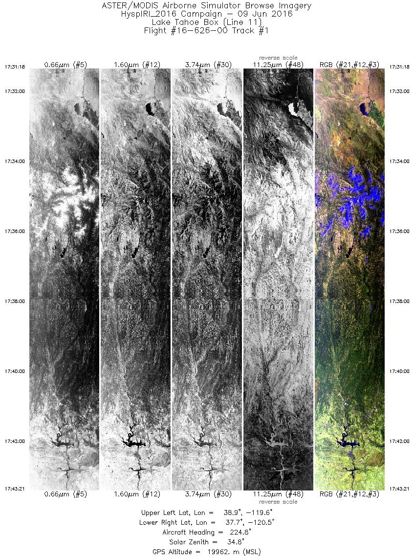
Get a related visualizationJPEG
Single-band images and an RGB composite image from flight track 1 as acquired...
-
Landing PageLanding Page
Dates
| Metadata Created Date | February 22, 2025 |
|---|---|
| Metadata Updated Date | February 22, 2025 |
Metadata Source
- Data.json Data.json Metadata
Harvested from nasa test json
Additional Metadata
| Resource Type | Dataset |
|---|---|
| Metadata Created Date | February 22, 2025 |
| Metadata Updated Date | February 22, 2025 |
| Publisher | ORNL_DAAC |
| Maintainer | |
| Identifier | C2731649277-ORNL_CLOUD |
| Data First Published | 2023-06-19 |
| Language | en-US |
| Data Last Modified | 2025-02-19 |
| Category | MASTER, HyspIRI Airborne, geospatial |
| Public Access Level | public |
| Bureau Code | 026:00 |
| Metadata Context | https://project-open-data.cio.gov/v1.1/schema/catalog.jsonld |
| Schema Version | https://project-open-data.cio.gov/v1.1/schema |
| Catalog Describedby | https://project-open-data.cio.gov/v1.1/schema/catalog.json |
| Harvest Object Id | 9f23404a-9cf6-4a99-b88e-3b569035fbe0 |
| Harvest Source Id | a73e0c30-4684-40ef-908e-d22e9e9e5f86 |
| Harvest Source Title | nasa test json |
| Homepage URL | https://doi.org/10.3334/ORNLDAAC/1913 |
| Metadata Type | geospatial |
| Old Spatial | -123.75 31.95 -112.5 40.98 |
| Program Code | 026:001 |
| Source Datajson Identifier | True |
| Source Hash | ea3cf51763fc7b52cd682cde70d1d6c93eb01dcc65540dee9a28d32e5543367e |
| Source Schema Version | 1.1 |
| Spatial | |
| Temporal | 2016-06-09T17:31:18Z/2016-06-22T01:12:00Z |
Didn't find what you're looking for? Suggest a dataset here.