
-
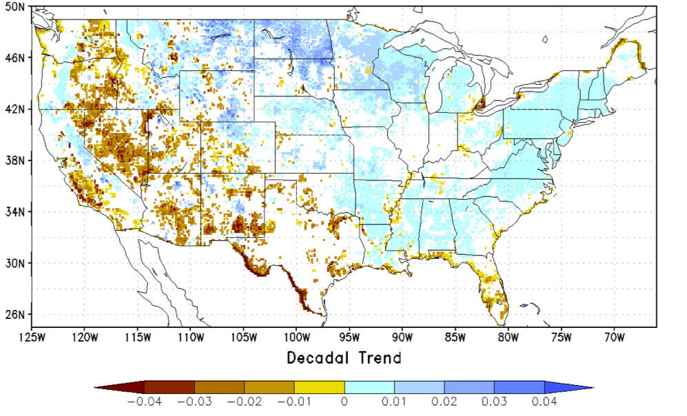
NCA-LDAS Noah-3.3 Land Surface Model L4 Trends 0.125 x 0.125 degree V2.0 (NCALDAS_NOAH0125_Trends) at GES DISC
The National Climate Assessment - Land Data Assimilation System, or NCA-LDAS, is a terrestrial water reanalysis in support of the United States Global Change Research Program's... -
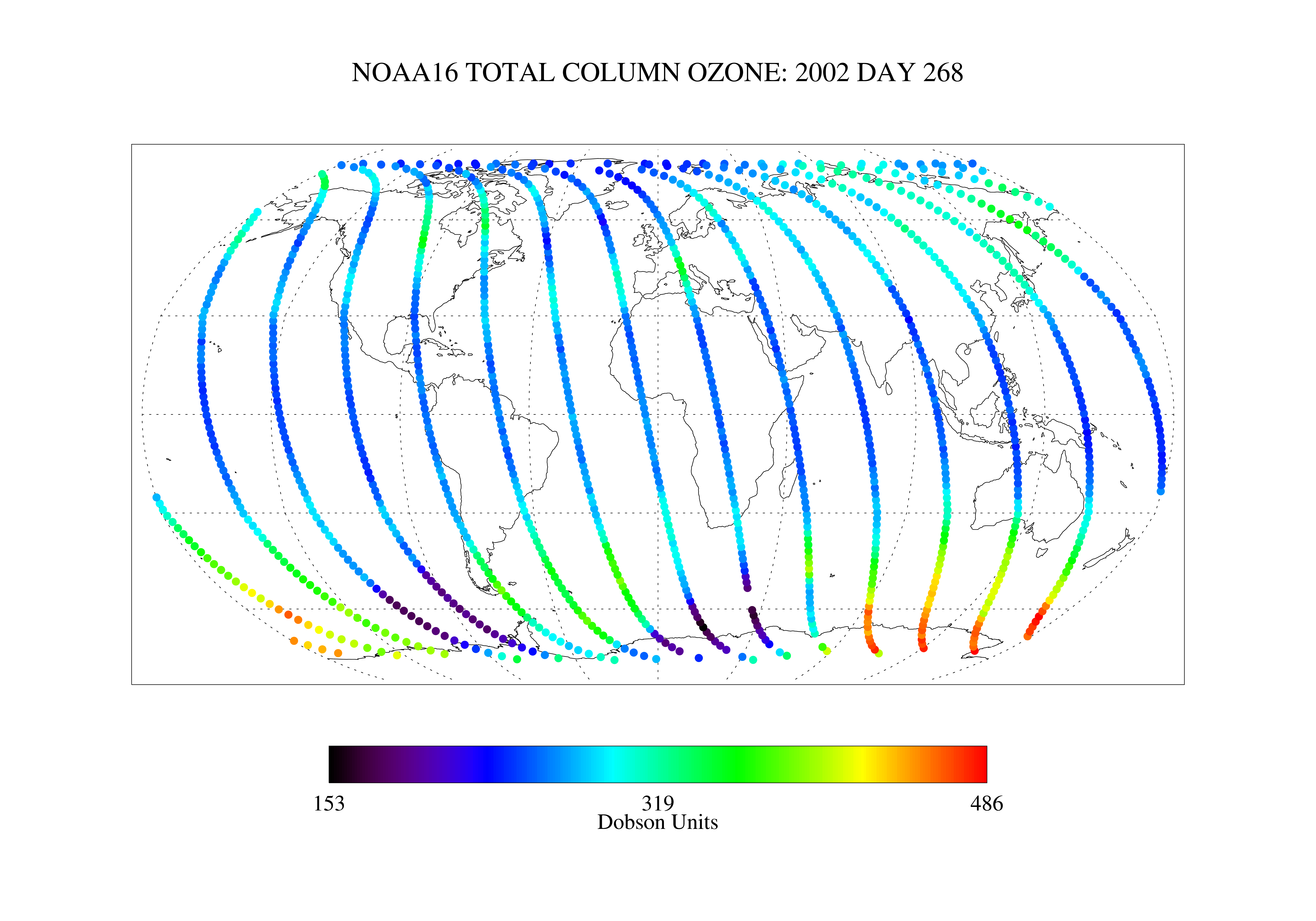
SBUV2/NOAA-16 Ozone (O3) Nadir Profile and Total Column 1 Day L2 V1 (SBUV2N16L2) at GES DISC
The Solar Backscattered Ultraviolet (SBUV) from NOAA-16 Level-2 daily product (SBUV2N16L2) contains ozone nadir profile and total column data from retrievals generated from the... -
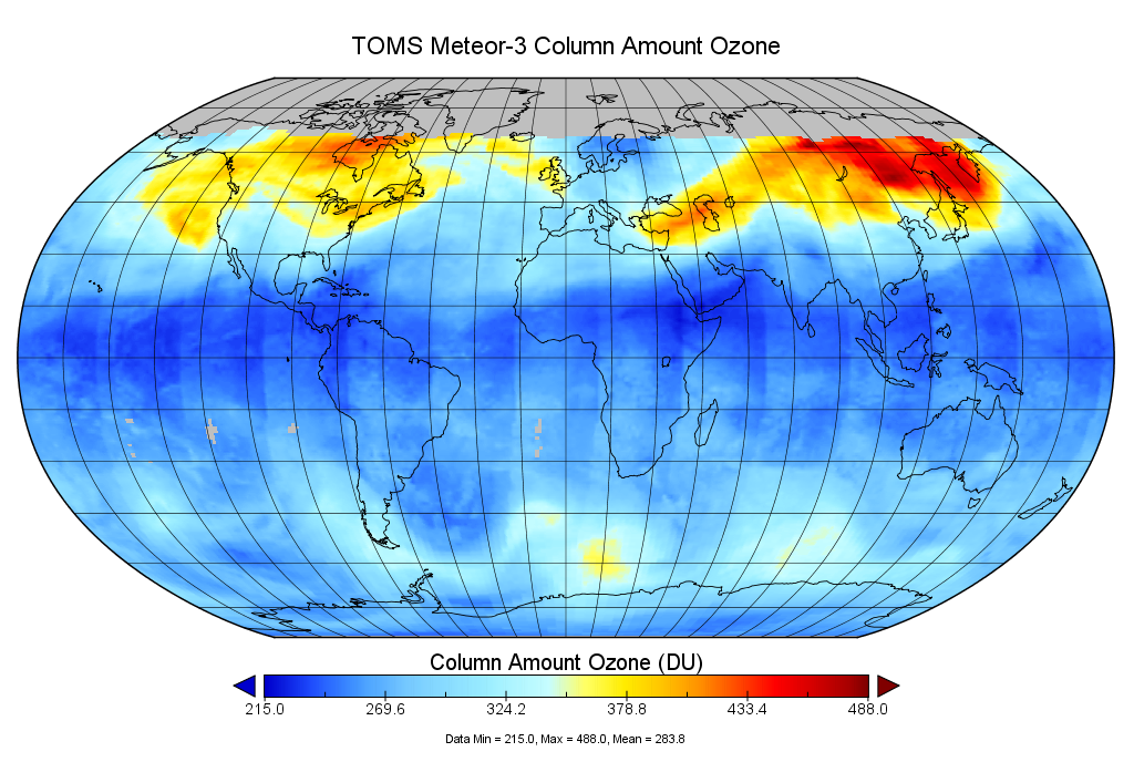
TOMS Meteor-3 Total Ozone UV-Reflectivity Daily L3 Global 1 deg x 1.25 deg V008 (TOMSM3L3) at GES DISC
The Meteor-3 Total Ozone Mapping Spectrometer (TOMS) version 8 daily global gridded data product contains total column ozone, UV aerosol index, Lambertian effective surface... -
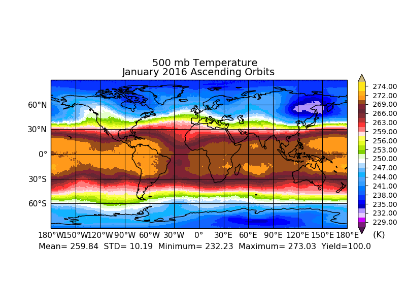
OCO-2 Level 2 meteorological parameters interpolated from global assimilation model for each sounding, Retrospective Processing V10r (OCO2_L2_Met) at GES DISC
Version 10r is the current version of the data set. Older versions will no longer be available and are superseded by Version 10r. In early 2021, the OCO Team identified an issue... -
GLDAS Catchment Land Surface Model L4 3 hourly 1.0 x 1.0 degree V2.0 (GLDAS_CLSM10_3H) at GES DISC
NASA Global Land Data Assimilation System Version 2 (GLDAS-2) has three components: GLDAS-2.0, GLDAS-2.1, and GLDAS-2.2. GLDAS-2.0 is forced entirely with the Princeton... -
GPM AMSUB on NOAA16 (GPROF) Climate-based Radiometer Precipitation Profiling L3 1 day 0.25 degree x 0.25 degree V07 (GPM_3GPROFNOAA16AMSUB_DAY_CLIM) at GES DISC
The "CLIM" products differ from their "regular" counterparts (without the "CLIM" in the name) by the ancillary data they use. They are Climate-Reference products, which requires... -
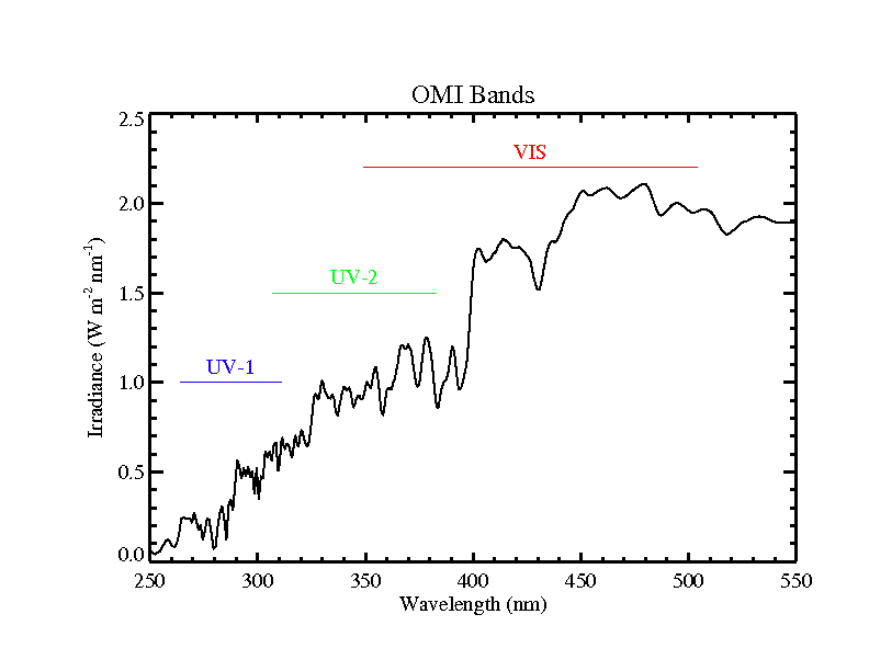
OMI/Aura Level 1B UV Global Geolocated Earthshine Radiances V004 (OML1BRUG) at GES DISC
The Aura Ozone Monitoring Instrument (OMI) Level 1B (L1B) Geolocated Earthshine UV Radiance, Global-mode (shortname OML1BRUG) Version 4 product contains geolocated Earth view... -
TROPESS Chemical Reanalysis Surface Pressure 6-Hourly 2-dimensional Product V1 (TRPSCRPS6H2D) at GES DISC
The TROPESS Chemical Reanalysis PS 6-Hourly 2-dimensional Product contains surface pressure values, a meteorological field. The data are part of the Tropospheric Chemical... -
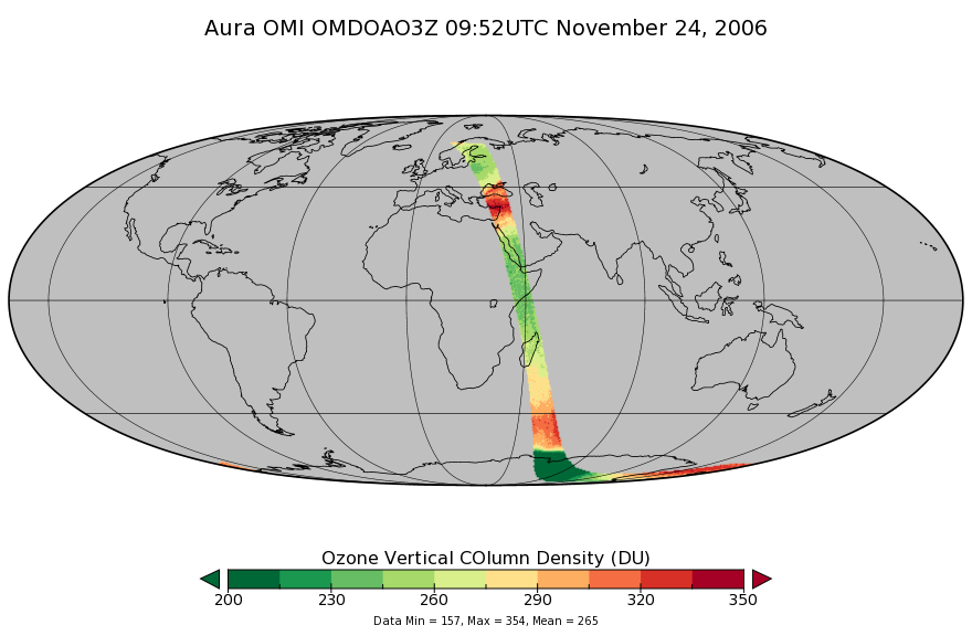
OMI/Aura DOAS Total Column Ozone Zoomed 1-Orbit L2 Swath 13x12km V003 (OMDOAO3Z) at GES DISC
The reprocessed Aura Ozone Monitoring Instrument (OMI) Level-2 Zoomed Ozone data product OMDOAO3Z at 13x12 km resolution is now available from the NASA Goddard Earth Sciences... -
OMI/Aura Chlorine Dioxide (OClO) Total Column 1-orbit L2 Swath 13x24 km V003 (OMOCLO) at GES DISC
The Aura Ozone Monitoring Instrument (OMI) collection-3 Chlorine Dioxide Product OMOCLO is now available from the NASA Goddard Earth Sciences Data and Information Services... -
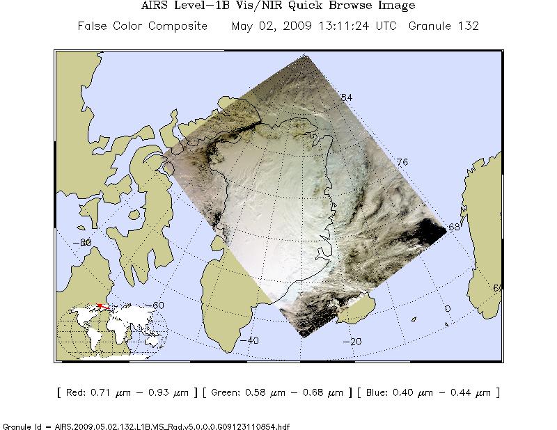
AIRS/Aqua L1B Near Real Time (NRT) Visible/Near Infrared (VIS/NIR) geolocated and calibrated radiances V005 (AIRVBRAD_NRT) at GES DISC
The AIRS Visible/Near Infrared (VIS/NIR) Level 1B Near Real Time (NRT) product (AIRVBRAD_NRT_005) differs from the routine product (AIRVBRAD_005) in 2 ways to meet the three... -
MERRA-2 tavgU_2d_rad_Nx: 2d,diurnal,Time-Averaged,Single-Level,Assimilation,Radiation Diagnostics 0.625 x 0.5 degree V5.12.4 (M2TUNXRAD) at GES DISC
M2TUNXRAD (or tavgU_2d_rad_Nx) is a time-averaged 2-dimensional monthly diurnal means data collection in Modern-Era Retrospective analysis for Research and Applications version... -
MERRA-2 tavgU_3d_tdt_Np: 3d,diurnal,Time-Averaged,Pressure-Level,Assimilation,Temperature Tendencies 0.625 x 0.5 degree V5.12.4 (M2TUNPTDT) at GES DISC
M2TUNPTDT (or tavgU_3d_tdt_Np) is a 3-dimensional monthly diurnal means data collection in Modern-Era Retrospective analysis for Research and Applications version 2 (MERRA-2).... -
TRMM Ground Validation Calibrated QC Radar Reflectivity Full Volume Scan L1C 1 hour V7 (TRMM_1C51UW) at GES DISC
This dataset is part of the University of Washington TRMM Ground Validation products. Files are in "Universal Format", described in BAMS, Vol 61, No 11, November 1980, pp.... -
MLS/Aura Level 3 Daily Binned Hypochlorous Acid (HOCl) Mixing Ratio on Zonal and Similar Grids V005 (ML3DZHOCL) at GES DISC
ML3DZHOCL is the EOS Aura Microwave Limb Sounder (MLS) daily binned on zonal and assorted vertical grids product for hypochlorous acid (HOCl) derived from radiances measured... -
NLDAS Mosaic Land Surface Model L4 Hourly 0.125 x 0.125 degree V002 (NLDAS_MOS0125_H) at GES DISC
This data set contains a series of land surface parameters simulated from the Mosaic land-surface model (LSM) for Phase 2 of the North American Land Data Assimilation System... -
Aqua/AIRS L3 Monthly Support Product (AIRS-only) 1 degree x 1 degree V7.0 at GES DISC
The Atmospheric Infrared Sounder (AIRS) is a grating spectrometer (R = 1200) aboard the second Earth Observing System (EOS) polar-orbiting platform, EOS Aqua. In combination... -
OMPS-NPP L2 NM Sulfur Dioxide (SO2) Total and Tropospheric Column swath orbital V2 (OMPS_NPP_NMSO2_L2) at GES DISC
The OMPS-NPP L2 NM Sulfur Dioxide (SO2) Total and Tropospheric Column swath orbital collection 2 version 2.0 product contains the retrieved sulfur dioxide (SO2) measured by the... -
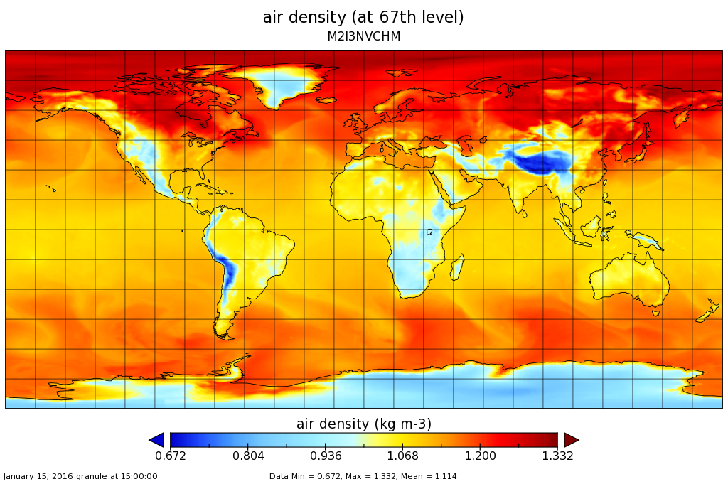
MERRA-2 inst3_3d_chm_Nv: 3d,3-Hourly,Instantaneous,Model-Level,Assimilation,Carbon Monoxide and Ozone Mixing Ratio 0.625 x 0.5 degree V5.12.4 (M2I3NVCHM) at GES DISC
M2I3NVCHM (or inst3_3d_chm_Nv) is an instantaneous 3-dimensional 3-hourly data collection in Modern-Era Retrospective analysis for Research and Applications version 2 (MERRA-2)....

Official websites use .gov
A
.gov website belongs to an official government
organization in the United States.
Secure .gov websites use HTTPS
A
lock (
) or https:// means you’ve safely connected to
the .gov website. Share sensitive information only on official,
secure websites.