

OMI/Aura Level 1B UV Global Geolocated Earthshine Radiances V004 (OML1BRUG) at GES DISC
Access & Use Information
Downloads & Resources
-
Google Scholar search resultsHTML
Search results for publications that cite this dataset by its DOI.
-
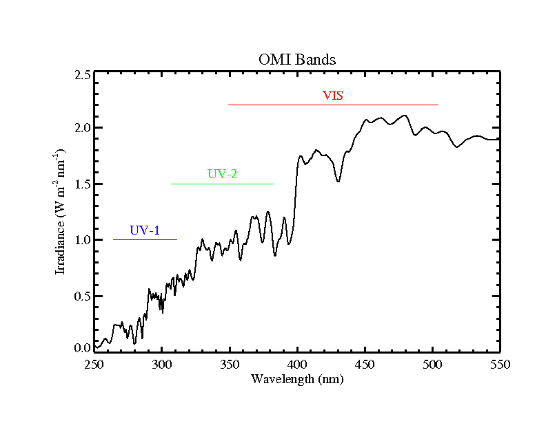
Get a related visualizationPNG
OML1BRUG_004.png
-
This dataset's landing pageHTML
Access the dataset landing page from the GES DISC website.
-
Download this dataset through a directory mapHTML
Access the data via HTTPS.
-
Download this dataset through Earthdata SearchHTML
Use the Earthdata Search to find and retrieve data sets across multiple data...
-
View this dataset's read me documentPDF
OMI v4 L1B README Document
-
View this dataset's algorithm theoretical...PDF
OMI v4 L01B Algorithm Theoretical Basis Documents
-
View the primary investigator's documentation...PDF
OMI v4 L01B Input Output Data Specification
-
View the primary investigator's documentation...PDF
OMI v4 L01B Metadata Specification
-
The dataset's project home pageHTML
Aura Project Home Page
-
The dataset's project home pageHTML
OMI KNMI Home Page
-
View this dataset's publicationsHTML
-
Landing PageLanding Page
Dates
| Metadata Created Date | February 21, 2025 |
|---|---|
| Metadata Updated Date | February 21, 2025 |
Metadata Source
- Data.json Data.json Metadata
Harvested from nasa test json
Additional Metadata
| Resource Type | Dataset |
|---|---|
| Metadata Created Date | February 21, 2025 |
| Metadata Updated Date | February 21, 2025 |
| Publisher | NASA/GSFC/SED/ESD/GCDC/GESDISC |
| Maintainer | |
| Identifier | C2045794784-GES_DISC |
| Data First Published | 2021-07-01 |
| Language | en-US |
| Data Last Modified | 2025-02-19 |
| Category | Aura, geospatial |
| Public Access Level | public |
| Bureau Code | 026:00 |
| Metadata Context | https://project-open-data.cio.gov/v1.1/schema/catalog.jsonld |
| Schema Version | https://project-open-data.cio.gov/v1.1/schema |
| Catalog Describedby | https://project-open-data.cio.gov/v1.1/schema/catalog.json |
| Harvest Object Id | 93e74302-2801-429d-a894-b5fdababeed5 |
| Harvest Source Id | a73e0c30-4684-40ef-908e-d22e9e9e5f86 |
| Harvest Source Title | nasa test json |
| Homepage URL | https://doi.org/10.5067/AURA/OMI/DATA1402 |
| Metadata Type | geospatial |
| Old Spatial | -180.0 -90.0 180.0 90.0 |
| Program Code | 026:001 |
| Source Datajson Identifier | True |
| Source Hash | 8a2a8bdec3e8cf98723f98f750be6f54d470a2517ad0dba58d62f52d2dc97527 |
| Source Schema Version | 1.1 |
| Spatial | |
| Temporal | 2004-10-01T00:00:00Z/2023-02-28T00:00:00Z |
Didn't find what you're looking for? Suggest a dataset here.