
-
SPURS-1 research vessel CTD profile data for N. Atlantic cruises
The SPURS (Salinity Processes in the Upper Ocean Regional Study) project is an oceanographic process study and associated field program that aim to elucidate key mechanisms... -
SWOT Level 2 Lake Single-Pass Vector Obs Data Product, Version 2.0
The SWOT Level 2 Lake Single-Pass Vector Obs Data Product from the Surface Water Ocean Topography (SWOT) mission provides water surface elevation, area, storage change derived... -
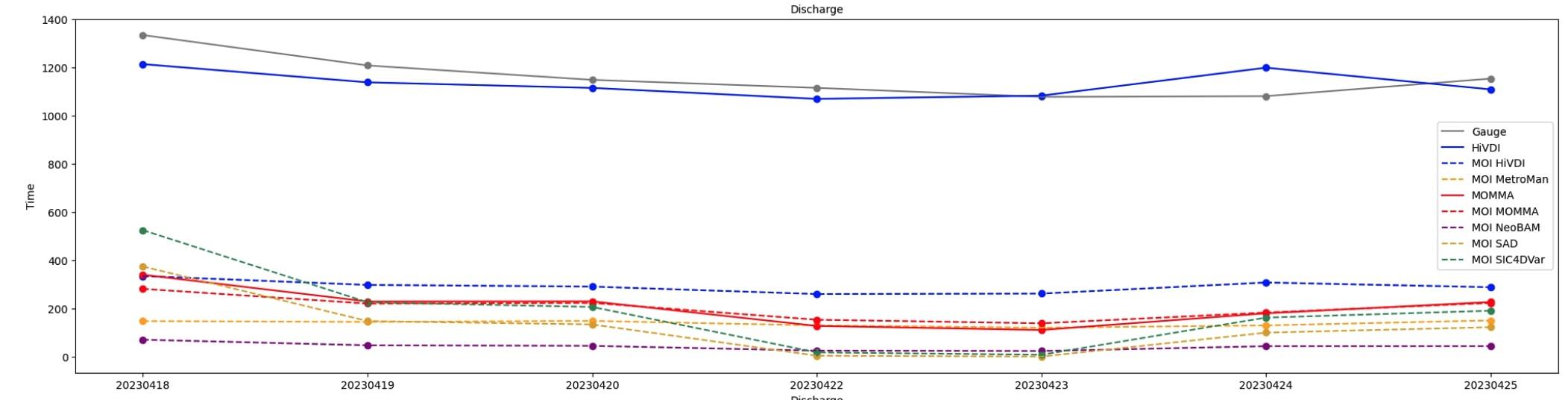
SWOT Sword of Science River Discharge Products Version 1
The SWOT Sword of Science River Discharge Products dataset from the Surface Water and Ocean Topography (SWOT) mission and produced by the Discharge Algorithm Working Group... -
GHRSST Level 4 MUR Global Foundation Sea Surface Temperature Analysis (v4.1) NGDA
A Group for High Resolution Sea Surface Temperature (GHRSST) Level 4 sea surface temperature analysis produced as a retrospective dataset (four day latency) and near-real-time... -
GHRSST Level 4 MW_IR_OI Global Foundation Sea Surface Temperature analysis version 5.0 from REMSS NGDA
A Group for High Resolution Sea Surface Temperature (GHRSST) global Level 4 sea surface temperature analysis produced daily on a 0.09-degree grid at Remote Sensing Systems. This... -
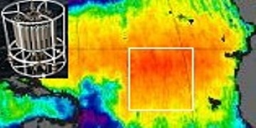
RapidScat Level 2A Surface Flagged Sigma-0 and Attenuations in 25km Swath Grid Version 2.0
This dataset contains the Version 2.0 ISS-RapidScat Level 2A 25km science data record, which provides surface-flagged sigma-0 in 25km Wind Vector Cells processed using the pulse... -
SWOT Level 2 Water Mask Pixel Cloud Data Product, Version 2.0
Point cloud of water mask pixels (“pixel cloud”) with geolocated heights, backscatter, geophysical fields, and flags. Point cloud over tile (approx 64x64 km2); half swath (left... -
Sentinel-6A MF Jason-CS L3 P4 Altimeter High Resolution (LR) NTC Ocean Surface Topography (Unfiltered) Version F08
Provides L3 low resolution (LR) non-time critical (NTC; 60-day latency) altimetry from the Poseidon-4 SAR altimeter on the Sentinel-6A Michael Freilich spacecraft, which... -
GRACE OCEAN BOTTOM GEOPOTENTIAL COEFFICIENTS CSR RELEASE 6.0 GAD
FOR EXPERT USE ONLY. This dataset contains estimates of ocean bottom pressure derived from the Gravity Recovery and Climate Experiment (GRACE) mission measurements, produced by... -
SPURS-1 research vessel Thermosalinograph series data for N. Atlantic cruises
The SPURS (Salinity Processes in the Upper Ocean Regional Study) project is an oceanographic process study and associated field program that aim to elucidate key mechanisms... -
GHRSST NOAA/STAR Metop-B AVHRR FRAC ACSPO v2.80 1km L2P Dataset (GDS v2)
The MetOp First Generation (FG) is a European multi-satellite program jointly established by ESA and EUMETSAT, comprising three satellites, MetOp-A, -B and -C. The primary... -
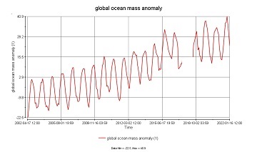
GRACE/GRACE-FO Level-4 Monthly Global Ocean Mass Anomaly version 01 from NASA MEaSUREs HOMaGE project
This data set contains the monthly Global Ocean Mass Anomalies (goma) since 04/2002, as measured by the GRACE and GRACE Follow-On (G/GFO) satellite missions. The data are... -
Northwest Australian Shelf Pre-SWOT Level-4 Hourly MITgcm LLC4320 Native Grid 2km Oceanographic Dataset Version 1.0
This dataset provides a regional multivariate oceanographic state estimate from a global ocean numerical simulation with a focus on the Northwest Australian Shelf region. The... -
MODIS Terra Level 3 SST Thermal IR Annual 4km Nighttime V2019.0 NGDA
Day and night spatially gridded (L3) global NASA skin sea surface temperature (SST) products from the Moderate-resolution Imaging Spectroradiometer (MODIS) onboard the Terra... -
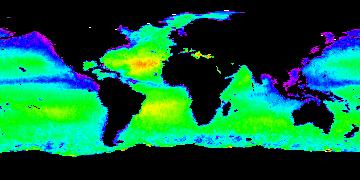
Aquarius Official Release Level 3 Sea Surface Salinity Standard Mapped Image Daily Data V5.0
Aquarius Level 3 sea surface salinity (SSS) standard mapped image data contains gridded 1 degree spatial resolution SSS averaged over daily, 7 day, monthly, and seasonal time... -
GHRSST NOAA/STAR GOES-16 ABI L2P America Region SST v2.70 dataset in GDS2
GOES-16 (G16) is the first satellite in the US NOAA third generation of Geostationary Operational Environmental Satellites (GOES), a.k.a. GOES-R series (which will also include... -
GHRSST Level 3U Global Subskin Sea Surface Temperature version7.0.1a from the WindSat Polarimetric Radiometer on the Coriolis satellite
The WindSat Polarimetric Radiometer, launched on January 6, 2003 aboard the Department of Defense Coriolis satellite, was designed to measure the ocean surface wind vector from... -
Aquarius Official Release Level 3 Sea Surface Salinity Standard Mapped Image 7-Day Running Mean Data V5.0
Aquarius Level 3 sea surface salinity (SSS) standard mapped image data contains gridded 1 degree spatial resolution SSS averaged over daily, 7 day, monthly, and seasonal time... -
Reconstructed Sea Level Version 1
The Reconstructed Sea Level dataset contains sea level anomalies derived from satellite altimetry and tide gauges. The satellite altimetric record provides accurate measurements...

Official websites use .gov
A
.gov website belongs to an official government
organization in the United States.
Secure .gov websites use HTTPS
A
lock (
) or https:// means you’ve safely connected to
the .gov website. Share sensitive information only on official,
secure websites.