
-
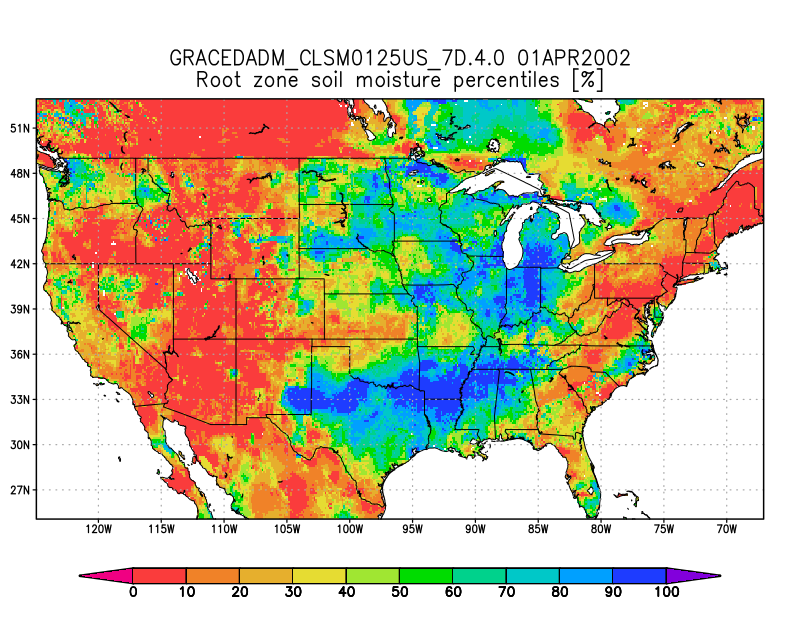
Groundwater and Soil Moisture Conditions from GRACE and GRACE-FO Data Assimilation L4 7-days 0.125 x 0.125 degree U.S. V4.0 (GRACEDADM_CLSM0125US_7D) at GES DISC
Scientists at NASA Goddard Space Flight Center generate groundwater and soil moisture drought indicators each week. They are based on terrestrial water storage observations... -
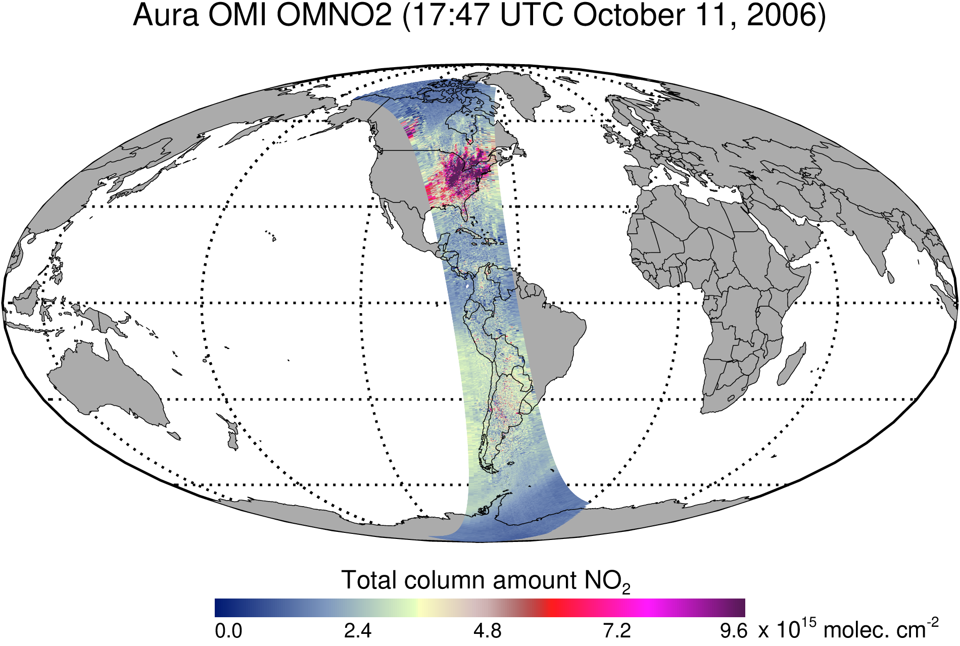
OMI/Aura Nitrogen Dioxide (NO2) Total and Tropospheric Column 1-orbit L2 Swath 13x24 km V003 (OMNO2) at GES DISC
The Version 4.0 Aura Ozone Monitoring Instrument (OMI) Nitrogen Dioxide (NO2) Standard Product (OMNO2) is now available from the NASA Goddard Earth Sciences Data and Information... -
GEOS-Carb CASA-GFED Monthly Fire Fuel NPP Rh NEE Fluxes 0.5 degree x 0.5 degree V2 (GEOS_CASAGFED_M_FLUX) at GES DISC
This product provides Monthly average Net Primary Production (NPP), heterotrophic respiration (Rh), wildfire emissions (FIRE), and fuel wood burning emissions (FUEL) derived... -
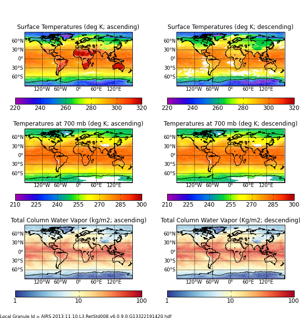
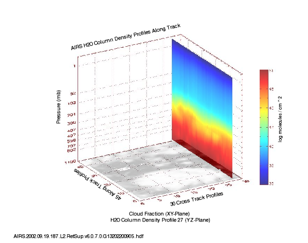
AIRS/Aqua L3 8-day Support Multiday Product (AIRS+AMSU) 1 degree x 1 degree V006 (AIRX3SP8) at GES DISC
The Atmospheric Infrared Sounder (AIRS) is a grating spectrometer (R = 1200) aboard the second Earth Observing System (EOS) polar-orbiting platform, EOS Aqua. In combination... -
FLDAS Noah Land Surface Model L4 Global Monthly 0.1 x 0.1 degree (GDAS and CHIRPS-PRELIM) V001 (FLDAS_NOAH01_CP_GL_M) at GES DISC
This dataset contains a series of land surface parameters simulated from the Noah 3.6.1 model in the Famine Early Warning Systems Network (FEWS NET) Land Data Assimilation... -
MERRA-2 instU_3d_asm_Np: 3d,diurnal,Instantaneous,Pressure-Level,Assimilation,Assimilated Meteorological Fields 0.625 x 0.5 degree V5.12.4 (M2IUNPASM) at GES DISC
M2IUNPASM (or instU_3d_asm_Np) is an instantaneous 3-dimensional monthly diurnal means data collection in Modern-Era Retrospective analysis for Research and Applications version... -
NLDAS Primary Forcing Data L4 Monthly Climatology 0.125 x 0.125 degree V2.0 (NLDAS_FORA0125_MC) at GES DISC
This data set contains the monthly climatology data of the primary forcing data for Phase 2 of the North American Land Data Assimilation System (NLDAS-2). The data are in 1/8th... -
AIRS/Aqua L3 Monthly Standard Physical Retrieval (AIRS-only) 1 degree x 1 degree V006 (AIRS3STM) at GES DISC
The Atmospheric Infrared Sounder (AIRS) is a grating spectrometer (R = 1200) aboard the second Earth Observing System (EOS) polar-orbiting platform, EOS Aqua. In combination... -
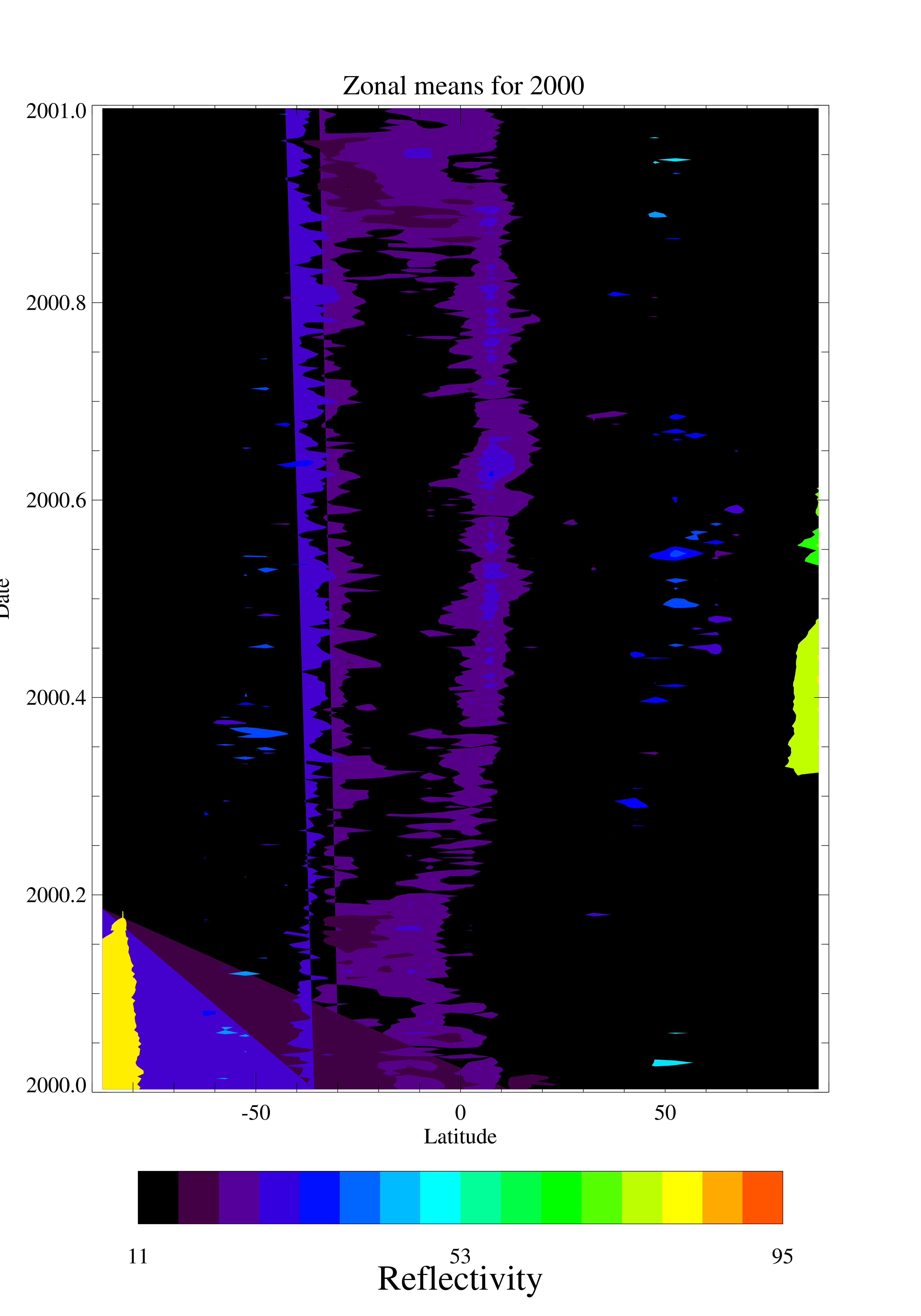
TOMS EP UV Reflectivity Daily and Monthly Zonal Means V008 (TOMSEPL3zref) at GES DISC
This Earth Probe (EP) Total Ozone Mapping Spectrometer (TOMS) version 8 daily zonal means data product contains Lambertian effective surface reflectivity values (Rayleigh... -
OMPS-NPP L2 NP Ozone (O3) Vertical Profile swath orbital
The OMPS-NPP L2 NP Ozone (O3) Total Column swath orbital product provides ozone profile retrievals from the Ozone Mapping and Profiling Suite (OMPS) Nadir-Profiler (NP)... -
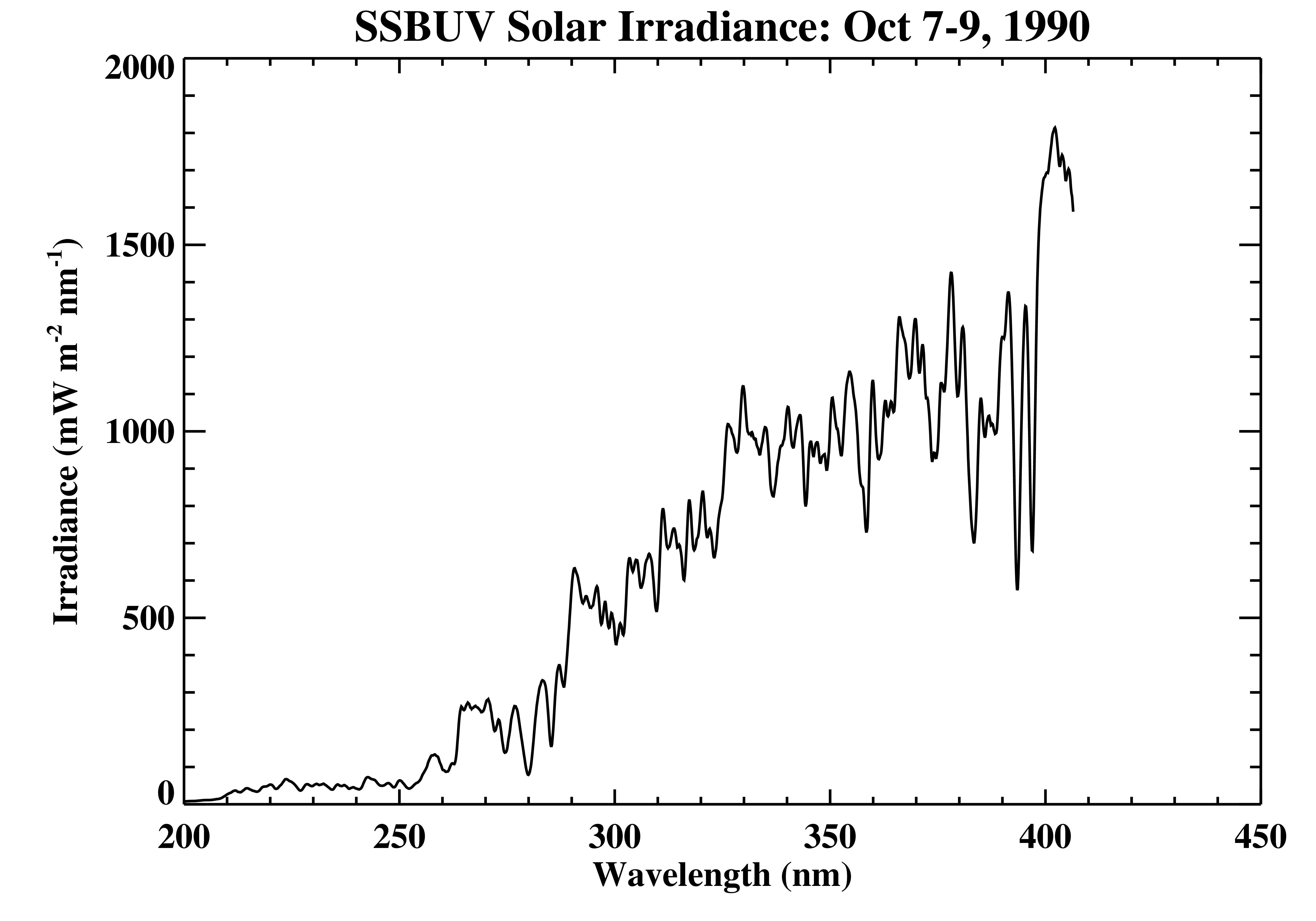
Shuttle SBUV (SSBUV) Solar Spectral Irradiance V008 (SSBUVIRR) at GES DISC
The Shuttle Solar Backscatter Ultraviolet (SSBUV) level-2 irradiance data are available for eight space shuttle missions flown between 1989 and 1996. SSBUV, a successor to the... -
TOVS GLA MONTHLY GRIDS from NOAA-11 V01 (TOVSAMNH) at GES DISC
This dataset (TOVSAMNH) contains the TIROS Operational Vertical Sounder (TOVS) level 3 geophysical parameters derived using data from NOAA-11 and the physical retrieval method... -
NLDAS Secondary Forcing Data L4 Monthly 0.125 x 0.125 degree V2.0 (NLDAS_FORB0125_M) at GES DISC
This data set contains the monthly secondary forcing data "File B" for Phase 2 of the North American Land Data Assimilation System (NLDAS-2). The data are in 1/8th degree grid... -
NLDAS Noah Land Surface Model L4 Monthly 0.125 x 0.125 degree V2.0 (NLDAS_NOAH0125_M) at GES DISC
This data set contains fifty-two fields simulated from the Noah land-surface model (LSM) for Phase 2 of the North American Land Data Assimilation System (NLDAS-2). The data are... -
GPM IMERG Final Precipitation L3 1 month 0.1 degree x 0.1 degree V07 (GPM_3IMERGM) at GES DISC
Version 07 is the current version of the data set. Older versions will no longer be available and have been superseded by Version 07. The Integrated Multi-satellitE Retrievals... -
NLDAS Secondary Forcing Data L4 Hourly 0.125 x 0.125 degree V2.0 (NLDAS_FORB0125_H) at GES DISC
This data set contains the secondary forcing hourly data "File B" for Phase 2 of the North American Land Data Assimilation System (NLDAS-2). The data are in 1/8th degree grid... -
FLDAS Noah Land Surface Model L4 Global Monthly Anomaly 0.1 x 0.1 degree (MERRA-2 and CHIRPS) V001 (FLDAS_NOAH01_C_GL_MA) at GES DISC
The monthly anomaly data set contains a series of land surface parameters simulated from the Noah 3.6.1 model in the Famine Early Warning Systems Network (FEWS NET) Land Data... -
AIRS/Aqua L2 Support Retrieval (AIRS+AMSU) V006 (AIRX2SUP) at GES DISC
The Atmospheric Infrared Sounder (AIRS) is a grating spectrometer (R = 1200) aboard the second Earth Observing System (EOS) polar-orbiting platform, EOS Aqua. In combination... -
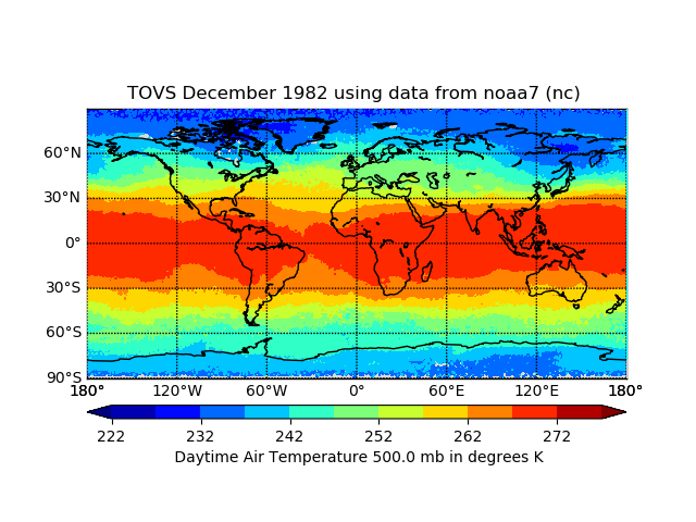
TOVS GLA MONTHLY GRIDS from NOAA-7 02 (TOVSAMNC) at GES DISC
This dataset (TOVSAMNC) contains the TIROS Operational Vertical Sounder (TOVS) level 3 geophysical parameters derived using data from NOAA-7 and the physical retrieval method of...

Official websites use .gov
A
.gov website belongs to an official government
organization in the United States.
Secure .gov websites use HTTPS
A
lock (
) or https:// means you’ve safely connected to
the .gov website. Share sensitive information only on official,
secure websites.