

Datasets
-
ROSETTA-ORBITER 67P RSI 1/2/3 COMET ESCORT 2 0696 V1.0
This is a Rosetta Radio Science data set, collected during the COMET ESCORT 2 phase 2015-03-11 to 2015-06-30. It is a Global Gravity measurement at the comet 67P and covers the... -
Collaborative Testing of Turbulence Models: Compressible Flow Cases from 1980-81 Data Library
This grouping contains the compressible-flow cases from the 1980-81 Data Library. -
ASTEROID LIGHTCURVE DERIVED DATA V7.0
This is a compilation of published lightcurve results through February, 2005. -
Earth Radiation Budget Experiment (ERBE) S-4GN (Nonscanner) Wide Field of View Numerical Filter (NF) Zonal and Global Averages
ERBE_S4GN_WFOV_NF_ZG data set contains Earth Radiation Budget Experiment (ERBE) S-4GN (Nonscanner-only) Wide Field of View Numerical Filter (NF) 5.0 and 10.0 degree Zonal and... -
USGS Group on Earth Observations (GEO) Global Agricultural Monitoring (GLAM) Algeria
The objective of GEO is to fulfil a vision of a world where decisions and actions are informed by coordinated, comprehensive and sustained Earth Observation (EO). This is being... -
MODIS/Terra Aerosol 5-Min L2 Swath 3km - NRT NGDA
The new Collection 6.1 (C61) MOD04_3K product is an improved version based on algorithm changes in Dark Target (DT) Aerosol retrieval over urban areas and uncertainty estimates... -
ROSETTA-ORBITER 67P RSI 1/2/3 COMET ESCORT 4 1247 V1.0
This is a Rosetta Radio Science data set, collected during the COMET ESCORT 4 phase 2015-10-22 to 2015-12-31. It is a Global Gravity measurement at the comet 67P and covers the... -
Disk Defect Data
How Data Was Acquired: The data presented is from a physical simulator that simulated engine disks. Sample Rates and Parameter Description: All parameters are sampled once per... -
MISR L2 TOA/Cloud Classifier Product subset for the RICO region V003
This is the Level 2 TOA/Cloud Classifiers Product subset for the RICO region. It contains the Angular Signature Cloud Mask (ASCM), Regional Cloud Classifiers, Cloud Shadow Mask,... -
SMEX05 Soil Moisture Network Data: Iowa, Version 1
Notice to Data Users: The documentation for this data set was provided solely by the Principal Investigator(s) and was not further developed, thoroughly reviewed, or edited by... -
CAMP2Ex P-3 In-Situ Aerosol Data
CAMP2Ex_Aerosol_AircraftInSitu_P3_Data are in-situ aerosol measurements conducted onboard the P-3 aircraft during the Clouds, Aerosol and Monsoon Processes-Philippines... -
APOLLO 17 TRAVERSE GRAVIMETER DATA V1.0
This data set contains a table of readings from the Traverse Gravimeter Experiment performed during the Apollo 17 mission. The gravimeter, which recorded relative measurements... -
ROSETTA-ORBITER 67P NAVCAM 3 COMET ESCORT 3 MTP020 V1.0
This dataset contains ROSETTA NAVCAM RADIOMETRICALLY CALIBRATED DATA of the COMET ESCORT 3 MTP020 Phase from 26 Aug. 2015, 06:02:17 to 22 Sep. 2015, 23:02:19 when at the... -
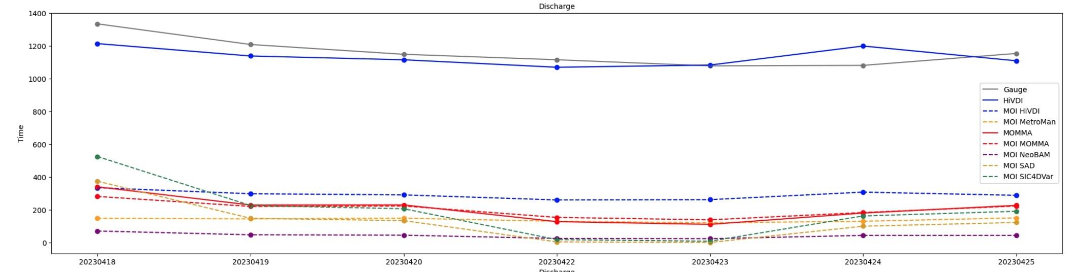
SWOT Sword of Science River Discharge Products Version 1
The SWOT Sword of Science River Discharge Products dataset from the Surface Water and Ocean Topography (SWOT) mission and produced by the Discharge Algorithm Working Group... -
ASTEROID NAMES AND DISCOVERY V11.0
This data set includes names, designations, and discovery circumstances for the asteroids numbered as of April 2, 2007. -
BOREAS TF-08 NSA-OJP and SSA-OBS Ceilometer Data
Ceilometer measurements of cloud characteristics made by the TF-08 team at the NSA-OJP and SSA-OBS sites. -
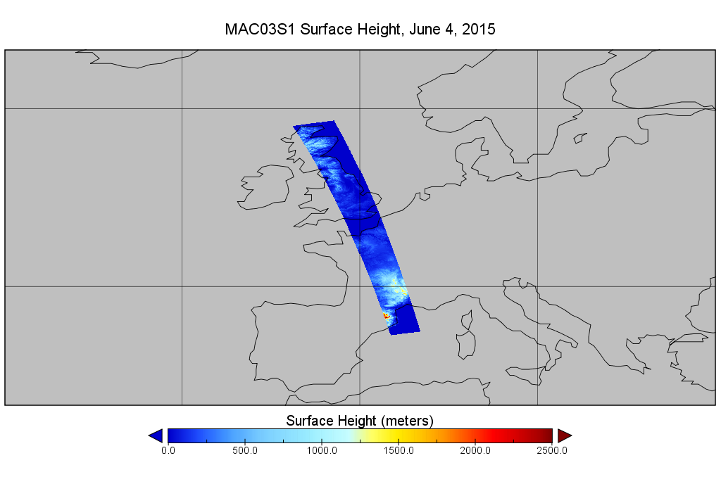
MODIS/Aqua Geolocation Fields 1km 5-Min 1A Wide Swath Subset along CloudSat V002 (MAC03S1) at GES DISC NGDA
This is the wide-swath MODIS/Aqua subset along CloudSat field of view track. The goal of the wide-swath subset is to select and return MODIS data that are within +-100 km across... -
MER1 Microscopic Imager Science Calibrated Data Bundle
This bundle contains calibrated data from the Microscopic Imager (MI) on Mars Exploration Rover 1 (Opportunity). These data were produced by the science team. -
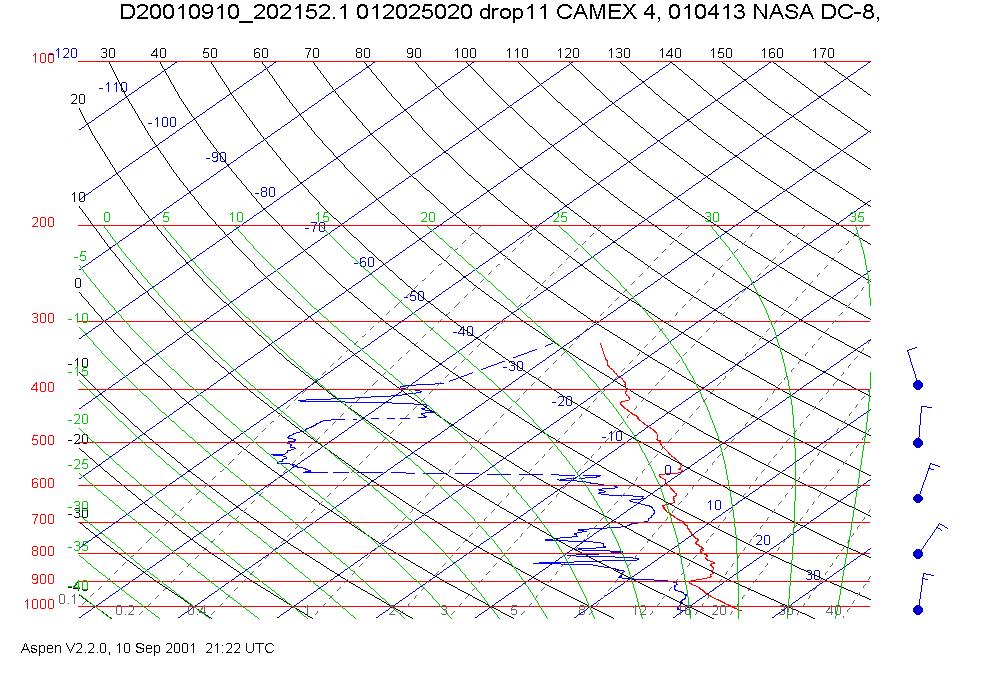
CAMEX-4 DC-8 DROPSONDE SYSTEM V1
The CAMEX-4 DC-8 Dropsonde System dataset was collected by the DC-8 Dropsonde System (D8D) uses dropwindsonde and Global Positioning System (GPS) receivers to measure the... -
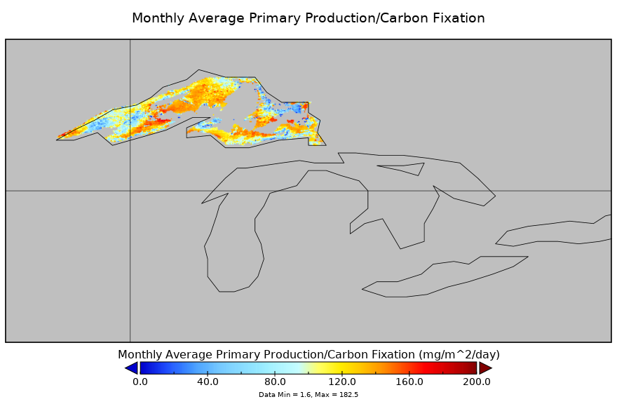
Carbon Monitoring System Lake Superior Primary Production Monthly V1 (CMSLakeSuperiorPPM) at GES DISC NGDA
Monthly Average primary production/carbon fixation data for Lake Superior. The primary production data is derived using MODIS imagery with model data. The NASA Carbon Monitoring...