

ABoVE: Atmospheric Gas Concentrations from Airborne Flasks, Arctic-CAP, 2017
Access & Use Information
Public: This dataset is intended for public access and use.
Non-Federal: This dataset is covered by different Terms of Use than Data.gov.
License: No license information was provided.
Downloads & Resources
-
Google Scholar search resultsHTML
Search results for publications that cite this dataset by its DOI.
-
Download this datasetHTML
This link allows direct data access via Earthdata login
-
View documentation related to this datasetHTML
ORNL DAAC Data Set Documentation
-
This dataset's landing pageHTML
Data set Landing Page DOI URL
-
View documentation related to this datasetPDF
ABoVE: Atmospheric Gas Concentrations, Airborne Flasks, Arctic-CAP, 2017:...
-
View documentation related to this datasetZIP
ABoVE: Atmospheric Gas Concentrations, Airborne Flasks from Arctic-CAP, 2017:...
-
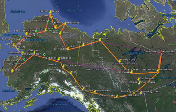
Get a related visualizationPNG
Arctic-CAP flight lines (orange) sample Arctic and boreal regions of Alaska...
-
The dataset's project home pageHTML
ABoVE project site
-
Landing PageLanding Page
Dates
| Metadata Created Date | February 22, 2025 |
|---|---|
| Metadata Updated Date | February 22, 2025 |
Metadata Source
- Data.json Data.json Metadata
Harvested from nasa test json
Additional Metadata
| Resource Type | Dataset |
|---|---|
| Metadata Created Date | February 22, 2025 |
| Metadata Updated Date | February 22, 2025 |
| Publisher | ORNL_DAAC |
| Maintainer | |
| Identifier | C2143812247-ORNL_CLOUD |
| Data First Published | 2022-05-10 |
| Language | en-US |
| Data Last Modified | 2025-02-19 |
| Category | ABoVE, geospatial |
| Public Access Level | public |
| Bureau Code | 026:00 |
| Metadata Context | https://project-open-data.cio.gov/v1.1/schema/catalog.jsonld |
| Schema Version | https://project-open-data.cio.gov/v1.1/schema |
| Catalog Describedby | https://project-open-data.cio.gov/v1.1/schema/catalog.json |
| Harvest Object Id | f735f305-95fe-4fd5-b794-8d408716ba27 |
| Harvest Source Id | a73e0c30-4684-40ef-908e-d22e9e9e5f86 |
| Harvest Source Title | nasa test json |
| Homepage URL | https://doi.org/10.3334/ORNLDAAC/1717 |
| Metadata Type | geospatial |
| Old Spatial | -165.48 58.08 -111.57 71.27 |
| Program Code | 026:001 |
| Source Datajson Identifier | True |
| Source Hash | 5a5b43cf75c57a4a9aebffc2438b475cb320c1f8798793e44c2cc26a03726031 |
| Source Schema Version | 1.1 |
| Spatial | |
| Temporal | 2017-04-27T00:00:00Z/2017-11-04T23:59:59Z |
Didn't find what you're looking for? Suggest a dataset here.