

ABoVE: AirSWOT Ka-band Radar over Surface Waters of Alaska and Canada, 2017
Access & Use Information
Public: This dataset is intended for public access and use.
Non-Federal: This dataset is covered by different Terms of Use than Data.gov.
License: No license information was provided.
Downloads & Resources
-
Google Scholar search resultsHTML
Search results for publications that cite this dataset by its DOI.
-
Download this datasetHTML
This link allows direct data access via Earthdata login
-
View documentation related to this datasetHTML
ORNL DAAC Data Set Documentation
-
This dataset's landing pageHTML
Data set Landing Page DOI URL
-
View documentation related to this datasetPDF
ABoVE: AirSWOT Ka-band Radar in the ABoVE Domain, 2017:...
-
View documentation related to this datasetKML
ABoVE: AirSWOT Ka-band Radar in the ABoVE Domain, 2017:...
-
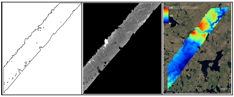
Get a related visualizationPNG
Example of AirSWOT radar products in ABoVE Projection at 3.6 m2 resolution,...
-
The dataset's project home pageHTML
ABoVE project site
-
Landing PageLanding Page
Dates
| Metadata Created Date | February 22, 2025 |
|---|---|
| Metadata Updated Date | February 22, 2025 |
Metadata Source
- Data.json Data.json Metadata
Harvested from nasa test json
Additional Metadata
| Resource Type | Dataset |
|---|---|
| Metadata Created Date | February 22, 2025 |
| Metadata Updated Date | February 22, 2025 |
| Publisher | ORNL_DAAC |
| Maintainer | |
| Identifier | C2111827036-ORNL_CLOUD |
| Data First Published | 2019-03-29 |
| Language | en-US |
| Data Last Modified | 2025-02-19 |
| Category | ABoVE, geospatial |
| Public Access Level | public |
| Bureau Code | 026:00 |
| Metadata Context | https://project-open-data.cio.gov/v1.1/schema/catalog.jsonld |
| Schema Version | https://project-open-data.cio.gov/v1.1/schema |
| Catalog Describedby | https://project-open-data.cio.gov/v1.1/schema/catalog.json |
| Harvest Object Id | 7aae45f8-37b7-4261-b89a-f866fcd5cb09 |
| Harvest Source Id | a73e0c30-4684-40ef-908e-d22e9e9e5f86 |
| Harvest Source Title | nasa test json |
| Homepage URL | https://doi.org/10.3334/ORNLDAAC/1646 |
| Metadata Type | geospatial |
| Old Spatial | -149.83 46.85 -98.63 70.49 |
| Program Code | 026:001 |
| Source Datajson Identifier | True |
| Source Hash | 4d7c6b18a66cad664dcd9fb54404cec5c98e29f31b71de6a37384af2a49c47b0 |
| Source Schema Version | 1.1 |
| Spatial | |
| Temporal | 2017-07-08T00:00:00Z/2017-08-17T23:59:59Z |
Didn't find what you're looking for? Suggest a dataset here.