

60 datasets found
-
GHRSST Level 4 MUR Global Foundation Sea Surface Temperature Analysis (v4.1) NGDA
NASA Test —
A Group for High Resolution Sea Surface Temperature (GHRSST) Level 4 sea surface temperature analysis produced as a retrospective dataset (four day latency) and near-... -
GHRSST Level 4 MW_IR_OI Global Foundation Sea Surface Temperature analysis version 5.0 from REMSS NGDA
NASA Test —
A Group for High Resolution Sea Surface Temperature (GHRSST) global Level 4 sea surface temperature analysis produced daily on a 0.09-degree grid at Remote Sensing... -
MODIS/Terra+Aqua Leaf Area Index/FPAR 4-Day L4 Global 500m SIN Grid V061 NGDA
NASA Test —
The MCD15A3H Version 6.1 Moderate Resolution Imaging Spectroradiometer (MODIS) Level 4, Combined Fraction of Photosynthetically Active Radiation (FPAR), and Leaf Area... -
MODIS Terra Level 3 SST Thermal IR Annual 4km Nighttime V2019.0 NGDA
NASA Test —
Day and night spatially gridded (L3) global NASA skin sea surface temperature (SST) products from the Moderate-resolution Imaging Spectroradiometer (MODIS) onboard the... -
ASTER L2 Surface Radiance VNIR and SWIR V003 NGDA
NASA Test —
The ASTER Surface Radiance VNIR and SWIR (AST_09) is a multi-file product (https://lpdaac.usgs.gov/documents/996/ASTER_Earthdata_Search_Order_Instructions.pdf) that... -
MODIS Aqua Level 3 SST Thermal IR Monthly 4km Nighttime V2019.0 NGDA
NASA Test —
Day and night spatially gridded (L3) global NASA skin sea surface temperature (SST) products from the Moderate-resolution Imaging Spectroradiometer (MODIS) onboard the... -
ASTER Orthorectified Digital Elevation Model (DEM) V003 NGDA
NASA Test —
The ASTER Digital Elevation Model and Orthorectified Registered Radiance at the Sensor (AST14DMO) product... -
MODIS Terra Level 3 SST MID-IR Monthly 9km Nighttime V2019.0 NGDA
NASA Test —
Day and night spatially gridded (L3) global NASA skin sea surface temperature (SST) products from the Moderate-resolution Imaging Spectroradiometer (MODIS) onboard the... -
ASTER L2 Surface Emissivity V003 NGDA
NASA Test —
The ASTER L2 Surface Emissivity is an on-demand product ((https://lpdaac.usgs.gov/documents/996/ASTER_Earthdata_Search_Order_Instructions.pdf)) generated using the... -
MODIS Aqua Level 3 SST Thermal IR 8 Day 9km Nighttime V2019.0 NGDA
NASA Test —
Day and night spatially gridded (L3) global NASA skin sea surface temperature (SST) products from the Moderate-resolution Imaging Spectroradiometer (MODIS) onboard the... -
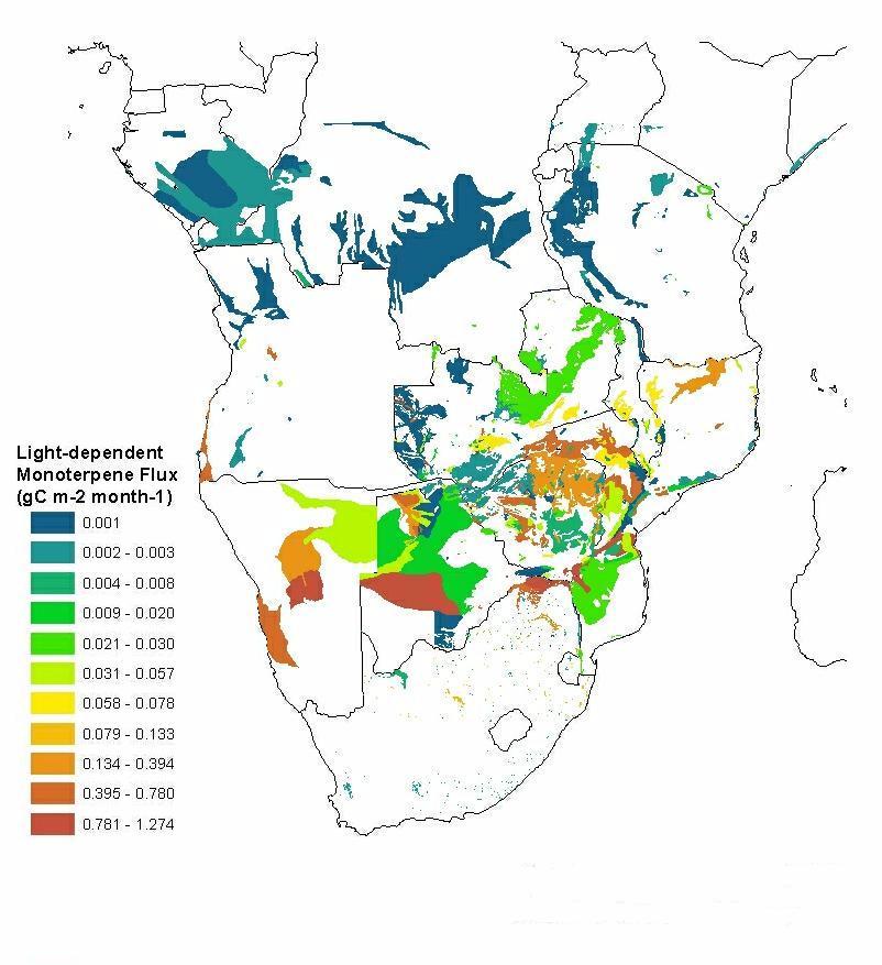
SAFARI 2000 Estimated BVOC Emissions for Southern African Land Cover Types NGDA
NASA Test —
Improved vegetation distribution and emission data for Africa south of the equator were developed for the Southern African Regional Science Initiative (SAFARI 2000)... -
Russian Boreal Forest Disturbance Maps Derived from Landsat Imagery, 1984-2000 NGDA
NASA Test —
This data set provides Boreal forest disturbance maps at 30-m resolution for 55 selected sites across Northern Eurasia within the Russian Federation. Disturbance... -
ABoVE: Fractional Open Water Cover for Pan-Arctic and ABoVE-Domain Regions, 2002-2015 NGDA
NASA Test —
This data set provides land surface fractional open water cover maps for two overlapping regions: the entire pan-Arctic region (latitude > 45 degrees) and the... -
2015 Urban Extents from VIIRS and MODIS for the Continental U.S. Using Machine Learning Methods NGDA
NASA Test —
The 2015 Urban Extents from VIIRS and MODIS for the Continental U.S. Using Machine Learning Methods data set models urban settlements in the Continental United States... -
Arctic Boreal Annual Burned Area, Circumpolar Boreal Forest and Tundra, V2, 2002-2022 NGDA
NASA Test —
This dataset provides annual cumulative end-of-season burned area in circumpolar boreal forests and tundra for the years 2002-2022. The data were generated using the... -
MODIS Terra Level 3 SST Thermal IR Daily 4km Nighttime V2019.0 NGDA
NASA Test —
Day and night spatially gridded (L3) global NASA skin sea surface temperature (SST) products from the Moderate-resolution Imaging Spectroradiometer (MODIS) onboard the... -
MODIS Terra Level 3 SST Thermal IR 8 Day 4km Nighttime V2019.0 NGDA
NASA Test —
Day and night spatially gridded (L3) global NASA skin sea surface temperature (SST) products from the Moderate-resolution Imaging Spectroradiometer (MODIS) onboard the... -
MODIS/Aqua Surface Reflectance 8-Day L3 Global 250m SIN Grid V061 NGDA
NASA Test —
The MYD09Q1 Version 6.1 product provides an estimate of the surface spectral reflectance of Aqua Moderate Resolution Imaging Spectroradiometer (MODIS) Bands 1 and 2,... -
MODIS-derived Aggregate, Woody and Herbaceous Leaf Area Index for Africa, 2002-2022 NGDA
NASA Test —
This dataset provides leaf area index (LAI) estimates for Sub-Saharan Africa for woody, herbaceous, and aggregate vegetation types. The estimates were derived from... -
ASTER Level 1 precision terrain corrected registered at-sensor radiance V003 NGDA
NASA Test —
The Advanced Spaceborne Thermal Emission and Reflection Radiometer (ASTER) Level 1 Precision Terrain Corrected Registered At-Sensor Radiance (AST_L1T) data contains...
60 datasets found