

164 datasets found
-
VIIRS/JPSS1 Day/Night Band 6-Min L1B Swath 750 m
NASA Test —
The VIIRS/JPSS1 Day/Night Band 6-Min L1B Swath 750 m, short-name VJ102DNB is platform-derived single NASA VIIRS panchromatic Day-Night band (DNB) calibrated radiance... -
Sounder SIPS: Suomi NPP ATMS Level 3 RAMSES2 Standard Gridded Monthly V3 at GES DISC
NASA Test —
This level 3 monthly product is generated from the RAMSES (Retrieval Algorithm for Microwave Sounders in Earth Science) II algorithm.The RAMSES II algorithm is a... -
VIIRS/JPSS1 Imagery Resolution Terrain Corrected Geolocation 6 Min L1 Swath 375m NRT
NASA Test —
The VIIRS/JPSS1 Imagery Resolution Terrain Corrected Geolocation 6-Min L1 Swath 375m Near Real Time (NRT) product, short-name VJ103IMG_NRT includes the geolocation... -
Sounder SIPS: AQUA AIRS IR + MW Level 3 CLIMCAPS: Specific Quality Control Gridded Monthly V2 at GES DISC
NASA Test —
WARNING: To users of the derived product “co_mmr_midtrop” (carbon monoxide mass mixing ratio to dry air [kg/kg] at ~500 hPa). This variable has a significant bias due... -
MODIS/Terra Aerosol Cloud Water Vapor Ozone Daily L3 Global 1Deg CMG NGDA
NASA Test —
The MODIS/Terra Aerosol Cloud Water Vapor Ozone Daily L3 Global 1Deg CMG product (MOD08_D3) contains daily 1 x 1 degree grid average values of atmospheric parameters... -
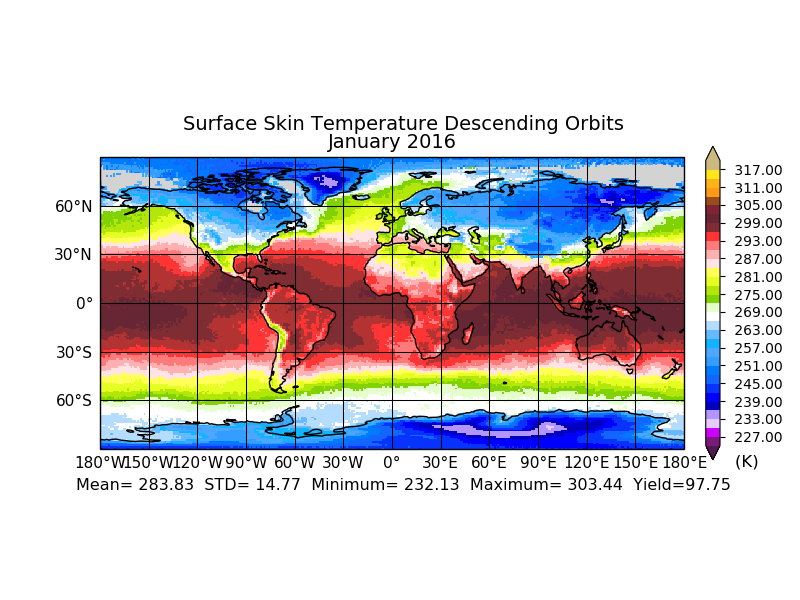
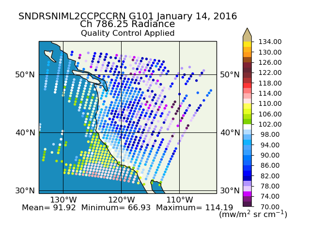
Sounder SIPS: Suomi NPP CrIMSS Level 2 CLIMCAPS Normal Spectral Resolution: Cloud Cleared Radiances V2 (SNDRSNIML2CCPCCRN) at GES DISC
NASA Test —
The CLIMCAPS (Community Long-term Infrared Microwave Coupled Product System) algorithm is used to analyze data from the Cross-track Infrared Sounder/Advanced... -
ABI G16 Deep Blue L3 Monthly Aerosol Data, 1 x 1 degree grid
NASA Test —
The ABI G16 Deep Blue L3 Monthly Aerosol Data, 1 x 1 degree grid product, short-name AERDB_M3_ABI_G16, derived by aggregating the L3 daily (AERDB_D3_ABI_G16) input... -
NOAA19 AVHRR Atmospherically Corrected Normalized Difference Vegetation Index Daily L3 Global 0.05 Deg. CMG
NASA Test —
The Long-Term Data Record (LTDR) produces, validates, and distributes a global land surface climate data record (CDR) that uses both mature and well-tested algorithms... -
VIIRS/JPSS2 Day/Night Band 6-Min L1B Swath SDR 750m NRT
NASA Test —
The Near Real Time (NRT) VIIRS Level 1 and Level 2 swath (VJ202DNB_NRT) product is single NASA VIIRS panchromatic Day-Night band (DNB) calibrated radiance product. The... -
Sounder SIPS: JPSS-1 ATMS Level 3 RAMSES2 Standard Gridded Daily V3 at GES DISC
NASA Test —
This level 3 daily product is generated from the RAMSES (Retrieval Algorithm for Microwave Sounders in Earth Science) II algorithm.The RAMSES II algorithm is a... -
STAQS NASA G-III GEOstationary Coastal and Air Pollution Events (GEO-CAPE) Airborne Simulator Data
NASA Test —
STAQS_AircraftRemoteSensing_NASA-G3_GCAS_Data is the remotely sensed trace gas data for the NASA Gulfstream III aircraft taken by the GEOstationary Coastal and Air... -
VIIRS/SNPP Deep Blue Aerosol L2 6 Min Swath 6km
NASA Test —
The VIIRS/SNPP Deep Blue Aerosol L2 6-Min Swath 6 km product from the Visible Infrared Imaging Radiometer Suite (VIIRS) determines atmospheric aerosol loading for... -
STAQS JSC GV GEOstationary Coastal and Air Pollution Events (GEO-CAPE) Airborne Simulator Data
NASA Test —
STAQS_AircraftRemoteSensing_JSC-GV_GCAS_Data is the remotely sensed trace gas data for the JSC Gulfstream V aircraft taken by the GEOstationary Coastal and Air... -
Sounder SIPS: AQUA AIRS IR + MW Level 2 CLIMCAPS: Cloud Cleared Radiances V2 at GES DISC
NASA Test —
The CLIMCAPS (Community Long-term Infrared Microwave Coupled Product System) algorithm is used to analyze data from the AIRS (Atmospheric Infrared Sounder) and AMSU...
164 datasets found