

459 datasets found
-
SPURS-1 research vessel CTD profile data for N. Atlantic cruises
NASA Test —
The SPURS (Salinity Processes in the Upper Ocean Regional Study) project is an oceanographic process study and associated field program that aim to elucidate key... -
GHRSST Level 4 MUR Global Foundation Sea Surface Temperature Analysis (v4.1) NGDA
NASA Test —
A Group for High Resolution Sea Surface Temperature (GHRSST) Level 4 sea surface temperature analysis produced as a retrospective dataset (four day latency) and near-... -
GHRSST Level 4 MW_IR_OI Global Foundation Sea Surface Temperature analysis version 5.0 from REMSS NGDA
NASA Test —
A Group for High Resolution Sea Surface Temperature (GHRSST) global Level 4 sea surface temperature analysis produced daily on a 0.09-degree grid at Remote Sensing... -
Ocean Surface Current Analyses Real-time (OSCAR) Surface Currents - Final 0.25 Degree (Version 2.0)
NASA Test —
Ocean Surface Current Analyses Real-time (OSCAR) is a global surface current database and NASA funded research project. OSCAR ocean mixed layer velocities are... -
Sentinel-6A MF Jason-CS L3 P4 Altimeter High Resolution (LR) NTC Ocean Surface Topography (Unfiltered) Version F08
NASA Test —
Provides L3 low resolution (LR) non-time critical (NTC; 60-day latency) altimetry from the Poseidon-4 SAR altimeter on the Sentinel-6A Michael Freilich spacecraft,... -
SPURS-1 research vessel Thermosalinograph series data for N. Atlantic cruises
NASA Test —
The SPURS (Salinity Processes in the Upper Ocean Regional Study) project is an oceanographic process study and associated field program that aim to elucidate key... -
GHRSST NOAA/STAR Metop-B AVHRR FRAC ACSPO v2.80 1km L2P Dataset (GDS v2)
NASA Test —
The MetOp First Generation (FG) is a European multi-satellite program jointly established by ESA and EUMETSAT, comprising three satellites, MetOp-A, -B and -C. The... -
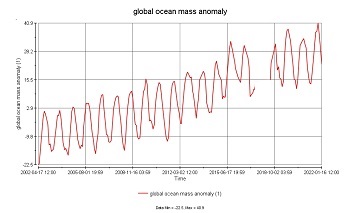
GRACE/GRACE-FO Level-4 Monthly Global Ocean Mass Anomaly version 01 from NASA MEaSUREs HOMaGE project
NASA Test —
This data set contains the monthly Global Ocean Mass Anomalies (goma) since 04/2002, as measured by the GRACE and GRACE Follow-On (G/GFO) satellite missions. The data... -
Northwest Australian Shelf Pre-SWOT Level-4 Hourly MITgcm LLC4320 Native Grid 2km Oceanographic Dataset Version 1.0
NASA Test —
This dataset provides a regional multivariate oceanographic state estimate from a global ocean numerical simulation with a focus on the Northwest Australian Shelf... -
MODIS Terra Level 3 SST Thermal IR Annual 4km Nighttime V2019.0 NGDA
NASA Test —
Day and night spatially gridded (L3) global NASA skin sea surface temperature (SST) products from the Moderate-resolution Imaging Spectroradiometer (MODIS) onboard the... -
Aquarius Official Release Level 3 Sea Surface Salinity Standard Mapped Image Daily Data V5.0
NASA Test —
Aquarius Level 3 sea surface salinity (SSS) standard mapped image data contains gridded 1 degree spatial resolution SSS averaged over daily, 7 day, monthly, and... -
GHRSST NOAA/STAR GOES-16 ABI L2P America Region SST v2.70 dataset in GDS2
NASA Test —
GOES-16 (G16) is the first satellite in the US NOAA third generation of Geostationary Operational Environmental Satellites (GOES), a.k.a. GOES-R series (which will... -
GHRSST Level 3U Global Subskin Sea Surface Temperature version7.0.1a from the WindSat Polarimetric Radiometer on the Coriolis satellite
NASA Test —
The WindSat Polarimetric Radiometer, launched on January 6, 2003 aboard the Department of Defense Coriolis satellite, was designed to measure the ocean surface wind... -
Aquarius Official Release Level 3 Sea Surface Salinity Standard Mapped Image 7-Day Running Mean Data V5.0
NASA Test —
Aquarius Level 3 sea surface salinity (SSS) standard mapped image data contains gridded 1 degree spatial resolution SSS averaged over daily, 7 day, monthly, and... -
Reconstructed Sea Level Version 1
NASA Test —
The Reconstructed Sea Level dataset contains sea level anomalies derived from satellite altimetry and tide gauges. The satellite altimetric record provides accurate... -
Aquarius Official Release Level 3 Sea Surface Density Standard Mapped Image Descending 7-Day Data V5.0
NASA Test —
Aquarius Level 3 sea surface density standard mapped image data contains gridded 1 degree spatial resolution density data averaged over daily, 7 day, monthly, and... -
Sentinel-6A MF Jason-CS L2 Advanced Microwave Radiometer (AMR-C) NTC Geophysical Parameters F08
NASA Test —
Provides L2 non-time critical (NTC; 60-day latency) validated geophysical information from the Advanced Microwave Radiometer on the Sentinel-6A Michael Freilich... -
NOAA Smith and Reynolds Extended Reconstructed Sea Surface Temperature (ERSST) Level 4 Monthly Version 5 Dataset in netCDF
NASA Test —
The Smith & Reynolds Extended Reconstructed Sea Surface Temperature (ERSST) Level 4 dataset provides a historical reconstruction of monthly global ocean surface... -
GHRSST Level 2P 1 m Depth Global Sea Surface Temperature from VIIRS on Suomi NPP (GDS2) V1
NASA Test —
A global Group for High Resolution Sea Surface Temperature (GHRSST) Level 2P dataset based on retrievals from the Visible Infrared Imaging Radiometer Suite (VIIRS)....
459 datasets found