

1,293 datasets found
-
CAR Discover AQ Air Quality L1 V1 (CAR_DISCOVERAQ_L1C) at GES DISC
NASA Test —
DISCOVER-AQ, a NASA Earth Venture program funded mission, stands for Deriving Information on Surface Conditions from Column and Vertically Resolved Observations... -
SNF Forest Cover by Species/Strata
NASA Test —
This is a combined data set of canopy, subcanopy and understory composition by vegetation species and study site ID -
BOREAS TGB-05 CO2, CH4, and CO Chamber Flux Data over the NSA
NASA Test —
Contains the TGB-05 CO, CO2, and CH4 flux data for sites in the Boreas Northern Study Area. -
VIIRS/JPSS1 Active Fires 6-Min L2 Swath 375m NRT
NASA Test —
The VJ114IMG_NRT is a Near Real Time (NRT) NOAA-20 (formally JPSS-1) /VIIRS 375 m active fire detection data product. Compared to other coarser resolution (≥1km)... -
MODIS/Terra+Aqua BRDF Model Parameters Daily L3 Global 1km SIN Grid V061 NGDA
NASA Test —
The MCD19A3D Version 6.1 data product is a Moderate Resolution Imaging Spectroradiometer (MODIS) Terra and Aqua combined Bidirectional Reflectance Distribution... -
VIIRS/NPP BRDF/Albedo Parameter 3 Band M5 Daily L3 Global 30 ArcSec CMG V001
NASA Test —
The NASA/NOAA Suomi National Polar-orbiting Partnership (Suomi NPP) Visible Infrared Imaging Radiometer Suite (VIIRS) Bidirectional Reflectance Distribution Function... -
BOREAS RSS-14 GOES-8 Level-1 Visible, Infrared and Water Vapor Images
NASA Test —
The level-1 BOREAS GOES-8 images are raw data values collected by RSS-14 personnel at FSU and delivered to BORIS. The data cover 14-Jul-1995 to 21-Sep-1995 and... -
VEMAP 1: Georeferencing
NASA Test —
An integrated input data set for ecosystem and vegetation modeling for the conterminous United States: Georeferencing -
ASTER Global Water Bodies Database NetCDF V001 NGDA
NASA Test —
The ASTER Global Water Bodies Database (ASTWBD) Version 1 data product provides global coverage of water bodies larger than 0.2 square kilometers at a spatial... -
High Mountain Asia 8-meter DEMs Derived from Along-track Optical Imagery V001
NASA Test —
This data set contains 8-meter Digital Elevation Models (DEMs) of high mountain Asia glacier and snow regions generated from very-high-resolution commercial... -
Moderate Resolution Imaging Spectroradiometer (MODIS) - Terra NGDA
NASA Test —
This dataset represents multiple products archived at the multiple archive centers for the MODIS (Moderate Resolution Imaging Spectroradiometer) instrument aboard the... -
CAR FIREACE Arctic Ice and Cloud Radiation L1 V1 (CAR_FIREACE_L1C) at GES DISC
NASA Test —
The scientific objectives of FIRE/ACE are to study impact of Arctic clouds on radiation exchange between surface, atmosphere, and space, and the influence of surface... -
ABoVE: Gridded 30-m Aboveground Biomass, Shrub Dominance, North Slope, AK, 2007-2016
NASA Test —
This dataset includes 30-m gridded estimates of total plant aboveground biomass (AGB), the shrub AGB, and the shrub dominance (shrub/plant AGB) for non-water portions... -
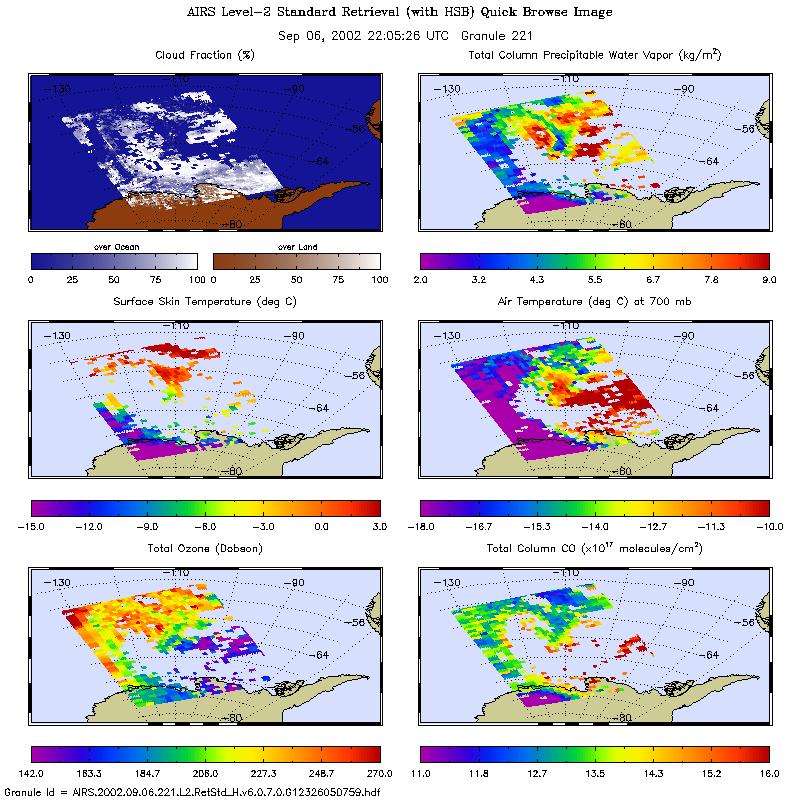
AIRS/Aqua L2 Standard Physical Retrieval (AIRS+AMSU+HSB) V006 (AIRH2RET) at GES DISC
NASA Test —
The Atmospheric Infrared Sounder (AIRS) is a grating spectrometer (R = 1200) aboard the second Earth Observing System (EOS) polar-orbiting platform, EOS Aqua. In... -
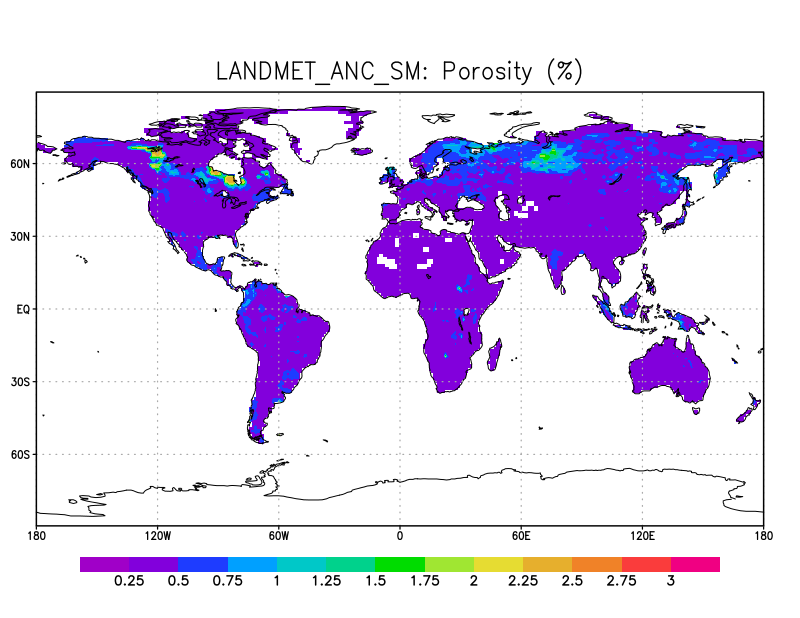
LANDMET Ancillary Soil Moisture data L3 V1 (LANDMET_ANC_SM) at GES DISC
NASA Test —
This ancillary climatology soil porosity and wetlands coverage information were derived from the daily GEWEX fusion of satellite active and passive microwave... -
MODIS/Aqua Land Surface Temperature/3-Band Emissivity Daily L3 Global 0.05Deg CMG V061 NGDA
NASA Test —
A new suite of MODIS Land Surface Temperature and Emissivity (LST&E) products are available in Collection 6.1. The MYD21 LST algorithm differs from the algorithm... -
Landsat Surface Reflectance - L8 OLI/TIRS
NASA Test —
Landsat satellite data have been produced, archived, and distributed by the U.S. Geological Survey (USGS) since 1972. Users rely on these data for historical study of... -
Aquarius L3 Gridded 1-Degree Monthly Soil Moisture Climatology V005
NASA Test —
This data set contains Level-3 gridded monthly global soil moisture climatology estimates derived from the NASA Aquarius passive microwave radiometer on the Satélite...
1,293 datasets found