

6,207 datasets found
-
SAFARI 2000 TOMS Tropospheric Ozone Data, Southern Africa Subset, Dry Season 2000
NASA Test —
Tropical Tropospheric Ozone (TTO) data from Earth Probe (EP) Total Ozone Mapping Spectrometer (TOMS) for the period of August 8-September 29, 2000 were processed and... -
Land Cover Classification, Snow Cover, and Fractional Snow-Covered Area Maps from Maxar WorldView Satellite Images V001
NASA Test —
This data set includes: (1) fine-scale snow and land cover maps from two mountainous study sites in the Western U.S., produced using machine-learning models trained to... -
Satellite Observations of Arctic Change, Version 1 NGDA
NASA Test —
The purpose of this site is to expose NASA satellite data and research on Arctic change in the form of maps that illustrate the changes taking place in the Arctic over... -
Quicklook Arctic Weekly EASE-Grid Sea Ice Motion Vectors, Version 1
NASA Test —
This data set is the quicklook version of the Polar Pathfinder Daily 25 km EASE-Grid Sea Ice Motion Vectors product (https://nsidc.org/data/nsidc-0116). It contains... -
NLDAS Primary Forcing Data L4 Monthly Climatology 0.125 x 0.125 degree V2.0 (NLDAS_FORA0125_MC) at GES DISC
NASA Test —
This data set contains the monthly climatology data of the primary forcing data for Phase 2 of the North American Land Data Assimilation System (NLDAS-2). The data are... -
MEaSUREs ITS_LIVE Regional Glacier and Ice Sheet Surface Velocities V001
NASA Test —
This data set from the Inter-Mission Time Series of Land Ice Velocity and Elevation (ITS_LIVE) project, part of NASA's Making Earth System Data Records for Use in... -
U.S. Population Grids (Summary File 1), 2000: Alabama, Louisiana, Mississippi and Texas, Alpha Version
NASA Test —
The U.S. Population Grids (Summary File 1), 2000: Alabama, Louisiana, Mississippi and Texas, Alpha Version data set contains an ARC/INFO Workspace with grids of... -
NACP Greenhouse Gases Multi-Source Data Compilation, 2000-2009
NASA Test —
This data set is a collection of measurements of carbon dioxide (CO2) and non-CO2 greenhouse gases made across North America by nine independent atmospheric monitoring... -
Air Temperatures at High Altitude, Kanchanjunga Himal, Eastern Nepal, Version 1
NASA Test —
This data set provides air temperature (1.5 m above ground surface) data from the Kanchanjunga Himal, eastern Nepal. Air temperature was monitored from November 1998... -
AIRS/Aqua L3 Monthly Standard Physical Retrieval (AIRS-only) 1 degree x 1 degree V006 (AIRS3STM) at GES DISC
NASA Test —
The Atmospheric Infrared Sounder (AIRS) is a grating spectrometer (R = 1200) aboard the second Earth Observing System (EOS) polar-orbiting platform, EOS Aqua. In... -
GHRSST Level 4 MUR Global Foundation Sea Surface Temperature Analysis (v4.1) NGDA
NASA Test —
A Group for High Resolution Sea Surface Temperature (GHRSST) Level 4 sea surface temperature analysis produced as a retrospective dataset (four day latency) and near-... -
First ISCCP Regional Experiment (FIRE) Cirrus Phase II National Center for Atmospheric Research (NCAR) Sabreliner Aircraft Data
NASA Test —
The First ISCCP Regional Experiments have been designed to improve data products and cloud/radiation parameterizations used in general circulation models (GCMs).... -
BOREAS TE-20 Site Characteristics Data
NASA Test —
The BOREAS TE-20 team collected several data sets for use in developing and testing models of forest ecosystem dynamics. This data set contains measurements of site... -
MODIS/Terra+Aqua Direct Broadcast Burned Area Monthly L3 Global 500m SIN Grid V061 NGDA
NASA Test —
The Terra and Aqua combined MCD64A1 Version 6.1 Burned Area data product is a monthly, global gridded 500 meter (m) product containing per-pixel burned-area and... -
TES/Aura L2 Ozone Nadir V008
NASA Test —
TL2O3N_8 is the Tropospheric Emission Spectrometer (TES)/Aura Level 2 Ozone Nadir Version 8 data product. It consists of information for one molecular species for an... -
NOAA-21 VIIRS Global Mapped Diffuse Attenuation Coefficient for Downwelling Irradiance (KD) - Near Real Time (NRT) Data, version R2022.0
NASA Test —
The Ocean Biology DAAC produces near real-time (quicklook) products using the best-available combination of ancillary data from meteorological and ozone data. As such,... -
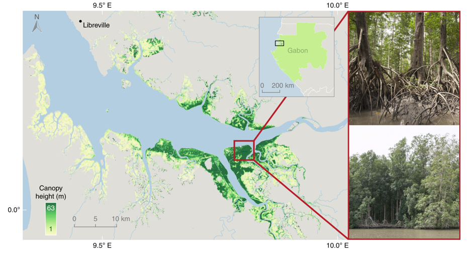
Global Mangrove Distribution, Aboveground Biomass, and Canopy Height
NASA Test —
This dataset characterizes the global distribution, biomass, and canopy height of mangrove-forested wetlands based on remotely sensed and in situ field measurement...
6,207 datasets found