

1,026 datasets found
-
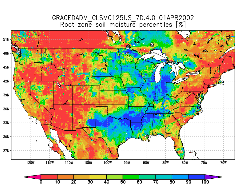
Groundwater and Soil Moisture Conditions from GRACE and GRACE-FO Data Assimilation L4 7-days 0.125 x 0.125 degree U.S. V4.0 (GRACEDADM_CLSM0125US_7D) at GES DISC
NASA Test —
Scientists at NASA Goddard Space Flight Center generate groundwater and soil moisture drought indicators each week. They are based on terrestrial water storage... -
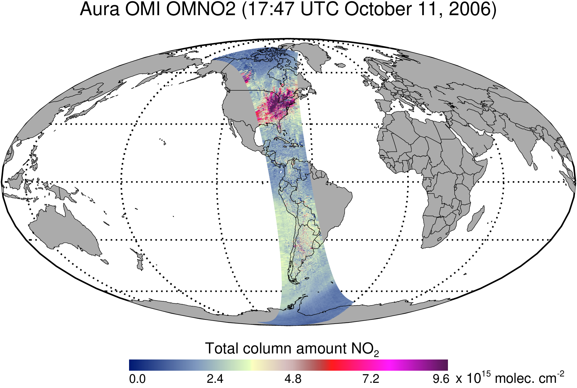
OMI/Aura Nitrogen Dioxide (NO2) Total and Tropospheric Column 1-orbit L2 Swath 13x24 km V003 (OMNO2) at GES DISC
NASA Test —
The Version 4.0 Aura Ozone Monitoring Instrument (OMI) Nitrogen Dioxide (NO2) Standard Product (OMNO2) is now available from the NASA Goddard Earth Sciences Data and... -
GEOS-Carb CASA-GFED Monthly Fire Fuel NPP Rh NEE Fluxes 0.5 degree x 0.5 degree V2 (GEOS_CASAGFED_M_FLUX) at GES DISC
NASA Test —
This product provides Monthly average Net Primary Production (NPP), heterotrophic respiration (Rh), wildfire emissions (FIRE), and fuel wood burning emissions (FUEL)... -
AIRS/Aqua L3 8-day Support Multiday Product (AIRS+AMSU) 1 degree x 1 degree V006 (AIRX3SP8) at GES DISC
NASA Test —
The Atmospheric Infrared Sounder (AIRS) is a grating spectrometer (R = 1200) aboard the second Earth Observing System (EOS) polar-orbiting platform, EOS Aqua. In... -
FLDAS Noah Land Surface Model L4 Global Monthly 0.1 x 0.1 degree (GDAS and CHIRPS-PRELIM) V001 (FLDAS_NOAH01_CP_GL_M) at GES DISC
NASA Test —
This dataset contains a series of land surface parameters simulated from the Noah 3.6.1 model in the Famine Early Warning Systems Network (FEWS NET) Land Data... -
MERRA-2 instU_3d_asm_Np: 3d,diurnal,Instantaneous,Pressure-Level,Assimilation,Assimilated Meteorological Fields 0.625 x 0.5 degree V5.12.4 (M2IUNPASM) at GES DISC
NASA Test —
M2IUNPASM (or instU_3d_asm_Np) is an instantaneous 3-dimensional monthly diurnal means data collection in Modern-Era Retrospective analysis for Research and... -
NLDAS Primary Forcing Data L4 Monthly Climatology 0.125 x 0.125 degree V2.0 (NLDAS_FORA0125_MC) at GES DISC
NASA Test —
This data set contains the monthly climatology data of the primary forcing data for Phase 2 of the North American Land Data Assimilation System (NLDAS-2). The data are... -
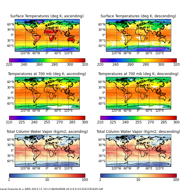
AIRS/Aqua L3 Monthly Standard Physical Retrieval (AIRS-only) 1 degree x 1 degree V006 (AIRS3STM) at GES DISC
NASA Test —
The Atmospheric Infrared Sounder (AIRS) is a grating spectrometer (R = 1200) aboard the second Earth Observing System (EOS) polar-orbiting platform, EOS Aqua. In... -
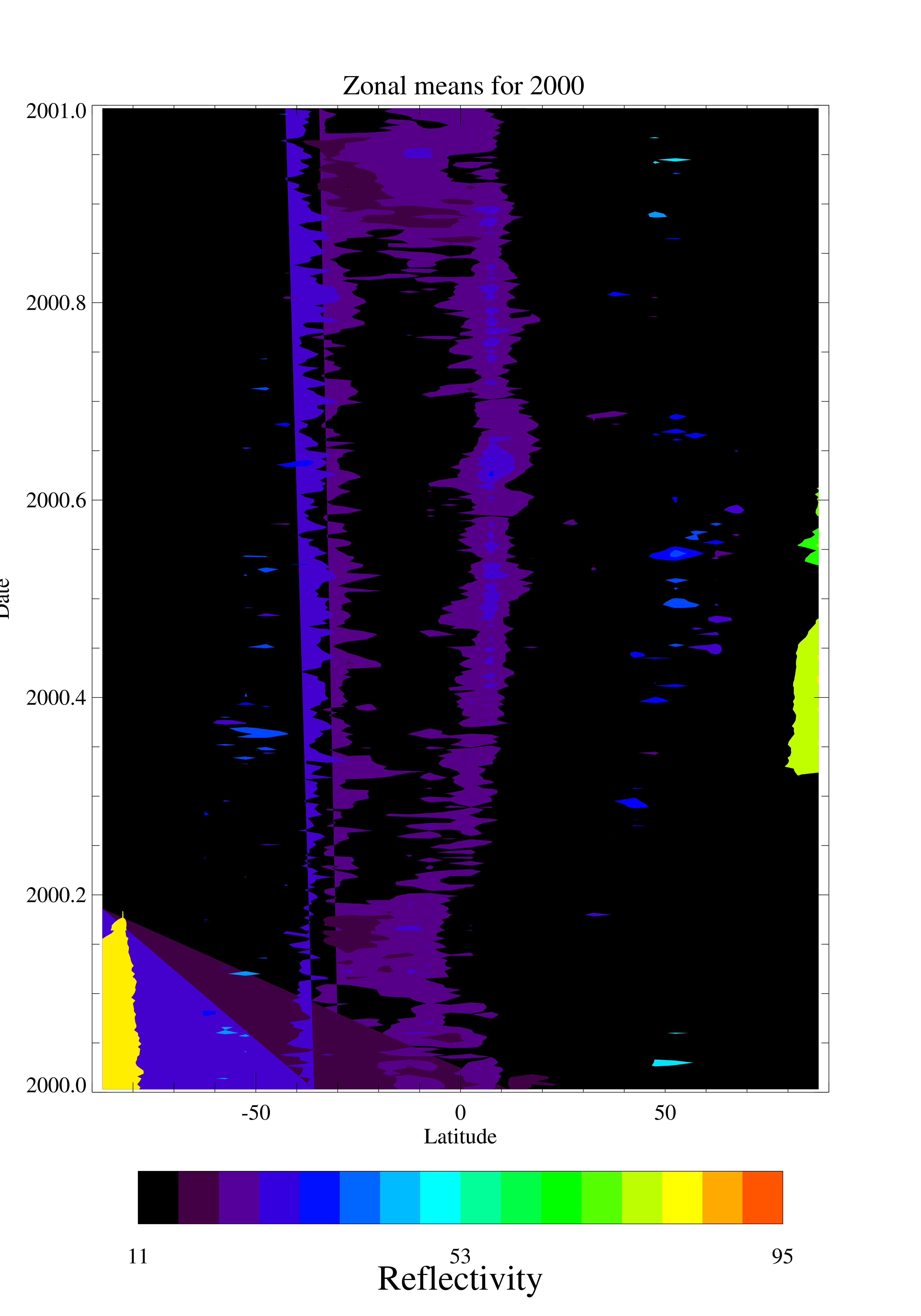
TOMS EP UV Reflectivity Daily and Monthly Zonal Means V008 (TOMSEPL3zref) at GES DISC
NASA Test —
This Earth Probe (EP) Total Ozone Mapping Spectrometer (TOMS) version 8 daily zonal means data product contains Lambertian effective surface reflectivity values... -
OMPS-NPP L2 NP Ozone (O3) Vertical Profile swath orbital
NASA Test —
The OMPS-NPP L2 NP Ozone (O3) Total Column swath orbital product provides ozone profile retrievals from the Ozone Mapping and Profiling Suite (OMPS) Nadir-Profiler... -
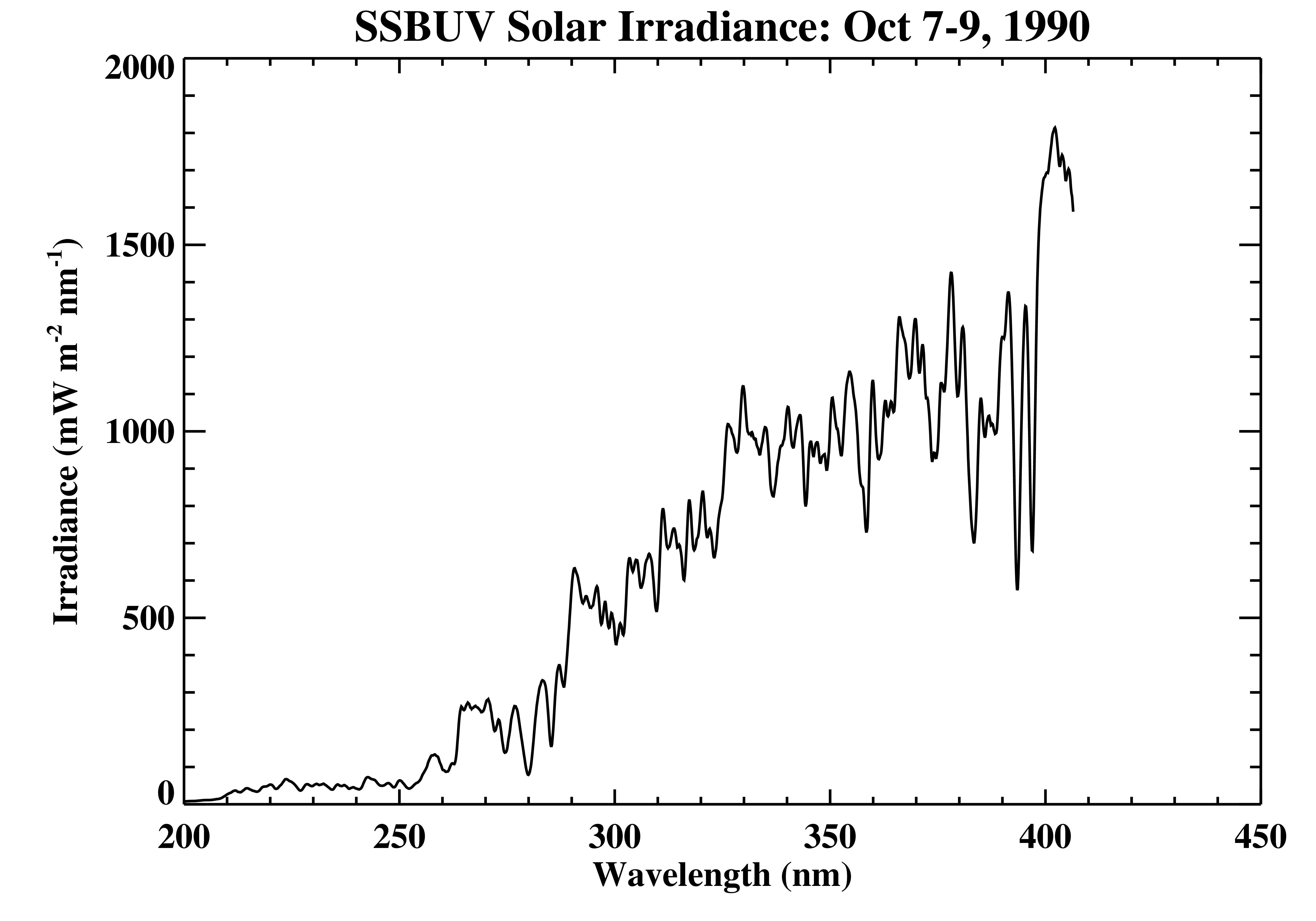
Shuttle SBUV (SSBUV) Solar Spectral Irradiance V008 (SSBUVIRR) at GES DISC
NASA Test —
The Shuttle Solar Backscatter Ultraviolet (SSBUV) level-2 irradiance data are available for eight space shuttle missions flown between 1989 and 1996. SSBUV, a... -
TOVS GLA MONTHLY GRIDS from NOAA-11 V01 (TOVSAMNH) at GES DISC
NASA Test —
This dataset (TOVSAMNH) contains the TIROS Operational Vertical Sounder (TOVS) level 3 geophysical parameters derived using data from NOAA-11 and the physical... -
NLDAS Secondary Forcing Data L4 Monthly 0.125 x 0.125 degree V2.0 (NLDAS_FORB0125_M) at GES DISC
NASA Test —
This data set contains the monthly secondary forcing data "File B" for Phase 2 of the North American Land Data Assimilation System (NLDAS-2). The data are in 1/8th... -
NLDAS Noah Land Surface Model L4 Monthly 0.125 x 0.125 degree V2.0 (NLDAS_NOAH0125_M) at GES DISC
NASA Test —
This data set contains fifty-two fields simulated from the Noah land-surface model (LSM) for Phase 2 of the North American Land Data Assimilation System (NLDAS-2). The... -
GPM IMERG Final Precipitation L3 1 month 0.1 degree x 0.1 degree V07 (GPM_3IMERGM) at GES DISC
NASA Test —
Version 07 is the current version of the data set. Older versions will no longer be available and have been superseded by Version 07. The Integrated Multi-satellitE... -
NLDAS Secondary Forcing Data L4 Hourly 0.125 x 0.125 degree V2.0 (NLDAS_FORB0125_H) at GES DISC
NASA Test —
This data set contains the secondary forcing hourly data "File B" for Phase 2 of the North American Land Data Assimilation System (NLDAS-2). The data are in 1/8th... -
FLDAS Noah Land Surface Model L4 Global Monthly Anomaly 0.1 x 0.1 degree (MERRA-2 and CHIRPS) V001 (FLDAS_NOAH01_C_GL_MA) at GES DISC
NASA Test —
The monthly anomaly data set contains a series of land surface parameters simulated from the Noah 3.6.1 model in the Famine Early Warning Systems Network (FEWS NET)... -
UARS Cryogenic Limb Array Etalon Spectrometer (CLAES) Level 3AT V009 (UARCL3AT) at GES DISC
NASA Test —
The Cryogenic Limb Array Etalon Spectrometer (CLAES) Level 3AT data product consists of daily, 65.536 second interval time-ordered vertical profiles of temperature and... -
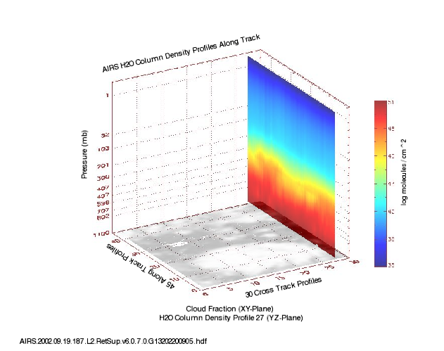
AIRS/Aqua L2 Support Retrieval (AIRS+AMSU) V006 (AIRX2SUP) at GES DISC
NASA Test —
The Atmospheric Infrared Sounder (AIRS) is a grating spectrometer (R = 1200) aboard the second Earth Observing System (EOS) polar-orbiting platform, EOS Aqua. In... -
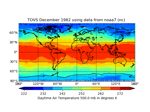
TOVS GLA MONTHLY GRIDS from NOAA-7 02 (TOVSAMNC) at GES DISC
NASA Test —
This dataset (TOVSAMNC) contains the TIROS Operational Vertical Sounder (TOVS) level 3 geophysical parameters derived using data from NOAA-7 and the physical retrieval...
1,026 datasets found