

24 datasets found
-
Integrated Tax System Public Extract Vacant Property
State of Washington —
This table is a subset of ITSPE and represents vacant property. The tax assessment roll public extract (ITSPE) is used for assessment and property analysis, to send... -
Address SMD and ANC Changes
State of Washington —
Addresses that have changed ANC and SMD as a result of new delineations in the Advisory Neighborhood Commission Boundaries Act of 2022, signed into law on June 16,... -
Topography Southwest DC - 2020
State of Washington —
0.6 meter contours. This dataset contains locations and attributes of 0.6 meter interval topography data, created using bare earth points from the lidar point cloud... -
Topography Northeast DC - 2020
State of Washington —
0.6 meter contours. This dataset contains locations and attributes of 0.6 meter interval topography data, created using bare earth points from the lidar point cloud... -
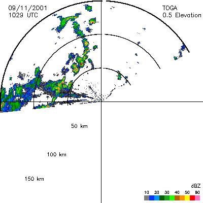
CAMEX-4 TOGA RADAR V1
NASA Test —
The TOGA radar dataset consists of browse and radar data collected from the TOGA radar during the CAMEX-4 experiment. TOGA is a C-band linear polarized doppler radar... -
FY23 Federal Real Property Profile (FRPP) Public Dataset
State of Washington —
The Federal Real Property Profile Management System (FRPP MS) is the federal government’s centralized inventory of real property under the custody and control of... -
Global Distribution of Root Turnover in Terrestrial Ecosystems
NASA Test —
Estimates of root turnover rates were calculated from measurements of live root standing crop and belowground net primary production (BNPP) compiled from the primary... -
DEA Laboratory Information Management System (LIMS) Drugs Analyzed Public Use File
State of Washington —
Data on received drugs analyzed in DEA Office of Forensic Sciences laboratories. Data is reported by drug type, by state, and by month. The DEA Office of Forensic... -
Federal Firearms Licensees - December 2021
State of Washington —
Complete listing of federal firearms licensees in December 2021 -
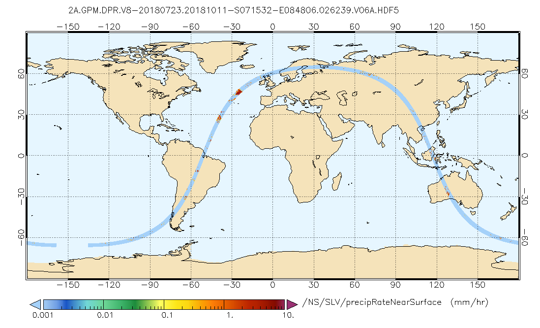
GPM DPR Precipitation Profile L2A 1.5 hours 5 km V07 (GPM_2ADPR) at GES DISC
NASA Test —
Version 07 is the current version of the data set. Older versions will no longer be available and have been superseded by Version 07. . 2ADPR provides single- and... -
NAMMA HIGH ALTITUDE MMIC SOUNDING RADIOMETER (HAMSR) V1
NASA Test —
The NAMMA High Altitude MMIC Sounding Radiometer (HAMSR) dataset consists of data collected by HAMSR, which is a 25-channel microwave atmospheric sounder operating as... -
Testing Locations Relate 6 23 2020
State of Washington —
COVID-19 testing sites in the District of Columbia. Individuals are encouraged to get tested through their own health care provider so that when the test results come... -
DCGov Testing Locations
State of Washington —
COVID-19 testing sites in the District of Columbia. Individuals are encouraged to get tested through their own health care provider so that when the test results come... -
Safe Passage Routes
State of Washington —
The Office of the Deputy Mayor for Public Safety and Justice (DMPSJ) is responsible for the day-to-day management of the District’s Safe Passage program. DMPSJ works... -
Topography Northwest DC - 2020
State of Washington —
0.6 meter contours. This dataset contains locations and attributes of 0.6 meter interval topography data, created using bare earth points from the lidar point cloud... -
Topography Southeast DC - 2020
State of Washington —
0.6 meter contours. This dataset contains locations and attributes of 0.6 meter interval topography data, created using bare earth points from the lidar point cloud... -
Topography Northeast DC - 2018
State of Washington —
0.6 meter contours. This dataset contains locations and attributes of 0.6 meter (1.9685 feet) interval topography data, created using bare earth points from the lidar... -
Topography Southeast DC - 2018
State of Washington —
0.6 meter contours. This dataset contains locations and attributes of 0.6 meter (1.9685 feet) interval topography data, created using bare earth points from the lidar... -
Topography Southwest DC - 2018
State of Washington —
0.6 meter contours. This dataset contains locations and attributes of 0.6 meter interval topography data, created using bare earth points from the lidar point cloud...
24 datasets found