
-
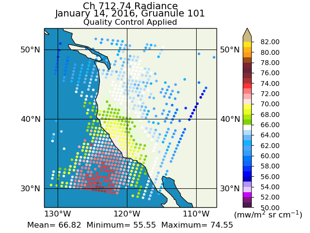
Sounder SIPS: Suomi NPP CrIMSS Level 2 CHART Normal Spectral Resolution: Atmosphere, cloud and surface geophysical state V1
The objective of this limited edition data collection is to examine products generated by the Climate Heritage AIRS Retrieval Technique (CHART) algorithm to analyze Cross-track... -
ABI G17 Deep Blue L3 Daily Aerosol Data, 1 x 1 degree grid
The ABI G17 Deep Blue L3 Daily Aerosol Data, 1 x 1 degree grid product, short-name AERDB_D3_ABI_G17, derived from the L2 (AERDB_L2_ABI_G17) input data, each D3 ABI/GOES-17... -
Sounder SIPS: Suomi NPP CrIMSS Level 3 Comprehensive Quality Control Gridded Monthly CLIMCAPS Full Spectral Resolution V2 at GES DISC
WARNING: To users of the derived product “co_mmr_midtrop” (carbon monoxide mass mixing ratio to dry air [kg/kg] at ~500 hPa). This variable has a significant bias due to a... -
VIIRS/JPSS2 Moderate Resolution Terrain Corrected Geolocation 6-Min L1 Swath IP 750m NRT
The Near Real Time (NRT) VIIRS/JPSS2 Moderate Resolution Terrain Corrected Geolocation 6-Min L1 Swath, short-name VJ203MOD_NRT) is the Joint Polar-orbiting Satellite System-2... -
METOP-B AVHRR Atmospherically Corrected Normalized Difference Vegetation Index Daily L3 Global 0.05 Deg. CMG
The Long-Term Data Record (LTDR) produces, validates, and distributes a global land surface climate data record (CDR) that uses both mature and well-tested algorithms in concert... -
H08 Deep Blue Level 3 monthly aerosol data, 1x1 degree grid
The H08 Deep Blue Level 3 Monthly aerosol data, 1x1 degree grid product, short-name AERDB_M3_AHI_H08, derived by aggregating the L3 daily (AERDB_D3_AHI_H08) input data, each M3... -
VIIRS/JPSS2 Moderate Resolution 6-Min L1B Swath SDR 750m NRT
The Near Real Time (NRT) VIIRS/JPSS2 Moderate Resolution 6-Min L1B Swath 750m, short-name VJ202MOD_NRT is the Joint Polar-orbiting Satellite System-2 (JPSS-2/NOAA-21; referred... -
MODIS/Aqua Land Surface Temperature/3-Band Emissivity 5-Min L2 1km NRT NGDA
The MODIS/Aqua Land Surface Temperature/3-Band Emissivity (LST&E) 5-Min L2 1km data product, short-name MYD21 is produced daily in five minute temporal increments of... -
VIIRS/JPSS1 Imagery Resolution 6 Min L1B Swath 375m NRT
The VIIRS/JPSS1 Imagery Resolution 6-Min L1B Swath 375m Near REal Time (NRT), short-name VJ102IMG_NRT is among the VIIRS Level 1 and Level 2 swath products that are generated... -
VIIRS/NPP Day/Night Band Terrain Corrected Geolocation L1 6-Min Swath 750 m
The VIIRS/NPP Day/Night Band Terrain Corrected Geolocation 6-Min L1 Swath 750m product, short-name VNP03DNB includes the geolocation fields that are calculated for Visible-... -
Sounder SIPS: AQUA AIRS IR-only Level 2 CLIMCAPS: Cloud Cleared Radiances V2 (SNDRAQIL2CCPCCR) at GES DISC
WARNING: To users of the derived product “co_mmr_midtrop” (carbon monoxide mass mixing ratio to dry air [kg/kg] at ~500 hPa). This variable has a significant bias due to a... -
MODIS/Terra Aerosol Cloud Water Vapor Ozone Monthly L3 Global 1Deg CMG NGDA
The MODIS/Terra Aerosol Cloud Water Vapor Ozone Monthly L3 Global 1Deg CMG product (MOD08_M3) contains monthly 1 x 1 degree grid average values of atmospheric parameters related... -
VIIRS/NPP Day/Night Band 6-Min L1B Swath 750 m
The VIIRS/NPP Day/Night Band 6-Min L1B Swath 750 m product, short-name VNP02DNB, is a panchromatic Day-Night band (DNB) calibrated radiance product. The DNB is one of the... -
Sounder SIPS: JPSS-1 CrIS Level 3 Comprehensive Quality Control Gridded Monthly CLIMCAPS V2 (SNDRJ1IML3CMCCP) at GES DISC
WARNING: To users of the derived product “co_mmr_midtrop” (carbon monoxide mass mixing ratio to dry air [kg/kg] at ~500 hPa). This variable has a significant bias due to a...

Official websites use .gov
A
.gov website belongs to an official government
organization in the United States.
Secure .gov websites use HTTPS
A
lock (
) or https:// means you’ve safely connected to
the .gov website. Share sensitive information only on official,
secure websites.