
-
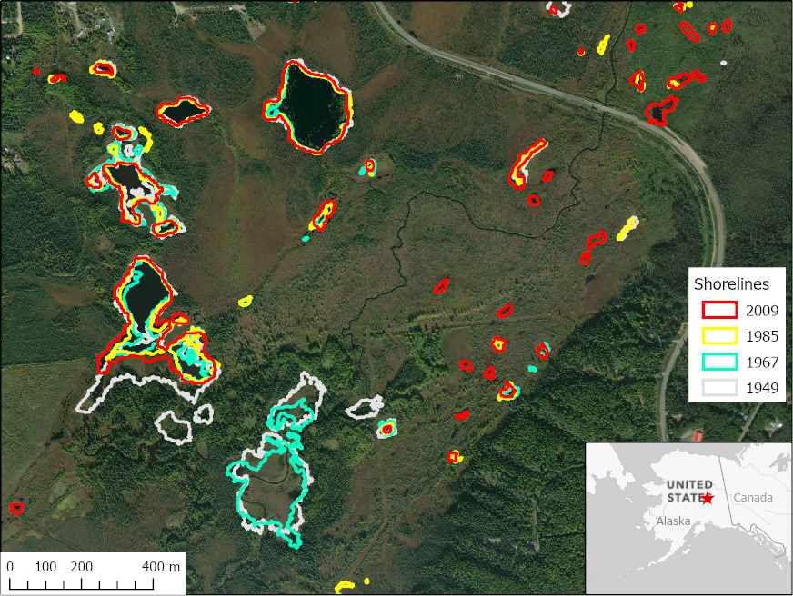
ABoVE: Historical Lake Shorelines and Areas near Fairbanks, Alaska from 1949-2009
This dataset includes maps of historical lake shorelines with derived lake areas in the southern portion of the Goldstream Valley and the surrounding landscape north of... -
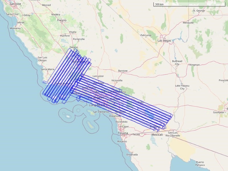
COMEX: AVIRIS-Classic Facility Instrument Associated Flights and Information, 2014
This dataset lists flight lines and provides data access links and contextual flight information for a subset of the AVIRIS-Classic Facility Instrument Collection that are... -
BigFoot GPP Surfaces for North and South American Sites, 2000-2004
The BigFoot project gathered Gross Primary Production (GPP) data for nine EOS Land Validation Sites located from Alaska to Brazil from 2000 to 2004. Each site is representative... -
ABoVE: Soil Temperature Profiles, USArray Seismic Stations, 2016-2021
This dataset includes soil temperature profile measurements taken at 63 monitoring sites associated with the USArray program, located across the NASA ABoVE domain in interior... -
ATom: L2 Trace Gas and Isotope Measurements from Medusa Whole Air Sampler, Version 2
This dataset provides O2/N2, CO2, Ar/N2, and stable isotope ratios of CO2 measured in flasks collected by the Medusa Whole Air Sampler during airborne campaigns conducted by... -
VEMAP 1: Selected Model Results
The Vegetation/Ecosystem Modeling and Analysis Project (VEMAP) was a multi-institutional, international effort addressing the response of biogeography and biogeochemistry to... -
Eddy Corr. Surface Flux: UNL (FIFE)
Latent & sensible heat flux by eddy correlation & aerodynamic characterization of vegetation -
CMS: LiDAR Data for Forested Areas in Paragominas, Para, Brazil, 2012-2014
This data set provides raw LiDAR point cloud data and derived Digital Terrain Models (DTMs) for five forested areas in the municipality of Paragominas, Para, Brazil, for the... -
CARVE: L1 Daily Flight Path and Winds Data, Alaska, 2015
This data set provides high-frequency wind speed and direction data for the C-23 Sherpa aircraft during airborne campaigns over the Alaskan and Canadian Arctic as part of the... -
Wind Profile Data: LIDAR - NOAA (FIFE)
Wind profile data from NOAA LIDAR measurements -
Maps of Vegetation Types and Physiographic Features, Toolik Lake Area, Alaska
This data set provides the spatial distributions of vegetation types, soil carbon, and physiographic features in the Toolik Lake area, Alaska. Specific attributes include... -
VEMAP 1: U.S. Site Files
An integrated input data set for ecosystem and vegetation modeling for the conterminous United States: Site Files -
BOREAS Level-1B TIMS Imagery: At Sensor Radiance in BSQ Format
TIMS imagery, along with other aircraft images, was collected to provide spatially extensive information over the primary study areas. The level-1B TIMS images cover the time... -
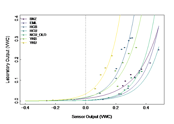
ABoVE: Soil Temperature and VWC at Unburned and Burned Sites Across Alaska, 2016-2023
This dataset provides soil temperature and volumetric water content (VWC) measurements at 15 cm depth collected at 12 selected boreal and tundra sites located across Alaska....

Official websites use .gov
A
.gov website belongs to an official government
organization in the United States.
Secure .gov websites use HTTPS
A
lock (
) or https:// means you’ve safely connected to
the .gov website. Share sensitive information only on official,
secure websites.