
-
BOREAS/SRC AMS Suite A Surface Meteorological and Radiation Data: 1994
Contains the data collected in 1994 by the AMS suite A instrument set operated by SRC and provided to BORIS. -
SAFARI 2000 SeaWiFS Images for the Southern African Region, 1999-2001
This data set contains Sea-viewing Wide Field-of-view Sensor (SeaWiFS) imagery for the southern African region. These images are Level-1a swaths of the southern African region... -
Aboveground Biomass Density for High Latitude Forests from ICESat-2, 2020
This dataset provides estimates of Aboveground dry woody Biomass Density (AGBD) for high northern latitude forests at a 30-m spatial resolution. It is designed both for boreal-... -
SAFARI 2000 Carbon in Live Vegetation, 0.5-Deg (Olson)
This data set is a subset of Olson's Major World Ecosystem Complexes for southern Africa in ASCII GRID and binary image file formats. Olson's Major World Ecosystem Complexes... -
ABoVE: Soil Temperature Profiles, USArray Seismic Stations, AK and Canada, 2016-2019
This dataset includes soil temperature profile measurements taken at 16 monitoring sites in Alaska, USA, and at one site in Yukon, Canada. The six sites are collocated with... -
BOREAS HYD-01 Soil Hydraulic Properties
Contains the hydraulic properties of the soil at each tower flux site determined by the HYD-01 science team. -
Delta-X: AirSWOT L3 Water Surface Elevations, MRD, Louisiana, 2021, Version 2
This dataset contains water surface elevations at selected point locations generated from the AirSWOT data collected during the Spring and Fall 2021 Delta-X deployments over the... -
Daymet: Monthly Climate Summaries on a 1-km Grid for North America, Version 4 R1
This dataset provides Daymet Version 4 R1 monthly climate summaries derived from Daymet Version 4 R1 daily data at a 1 km x 1 km spatial resolution for five Daymet variables:... -
ACT-America: WRF-Chem Baseline Simulations for North America, 2016-2019
This dataset includes hourly output from the WRF-Chem simulation model for North America at a resolution of 27 km for 2016-06-29 through 2019-07-31. WRF-Chem is the Weather... -
NWS Daily Climatology Data: 1974 (SNF)
Daily min, max, average temperature (F), precipitation (water equivalent in inches), and daily insolation (Langleys) for the Superior National Forest area as collected by NWS... -
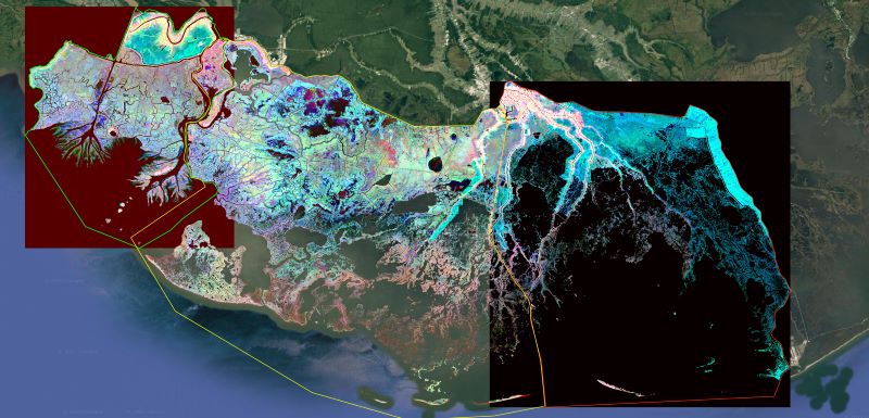
Delta-X: Ecogeomorphic Cell Products across the MRD, LA, USA, 2021
This product delineates the Mississippi River Delta (MRD) landscape into distinct ecogeomorphic cells, which are small contiguous areas of land with similar ecological and... -
LBA-ECO CD-10 Tree DBH Measurements at the km 67 Tower Site, Tapajos National Forest
This data sets reports diameter at breast height (DBH) measurements in the old-growth upland forest at the Para Western (Santarem) - km 67, Primary Forest Tower Site. This site... -
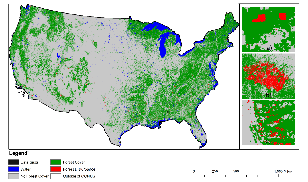
NACP NAFD Project: Forest Disturbance History from Landsat, 1986-2010
The North American Forest Dynamics (NAFD) products provided in this data set consist of 25 annual and two time-integrated forest disturbance maps for the conterminous United... -
CMS: Forest Carbon Stocks, Emissions, and Net Flux for the Conterminous US: 2005-2010
This data set provides maps of estimated carbon in forests of the 48 continental states of the US for the years 2005-2010. Carbon (termed committed carbon) stocks were estimated... -
BOREAS RSS-16 AIRSAR CM V6.1 Images
Satellite and aircraft SAR data used in conjunction with ground measurements to determine the moisture regime of the boreal forest. The NASA JPL AIRSAR is a side-looking imaging...

Official websites use .gov
A
.gov website belongs to an official government
organization in the United States.
Secure .gov websites use HTTPS
A
lock (
) or https:// means you’ve safely connected to
the .gov website. Share sensitive information only on official,
secure websites.