
-
Delta-X: Delft3D Broad-Scale Sediment Model, Terrebonne Basin, MRD, Louisiana, USA
This dataset contains the Delft3D model of the Terrebonne Basin along the Mississippi River Delta (MRD) in coastal Louisiana. Simulations cover the Delta-X Spring and Fall... -
Satellite SPOT Extracted Data (FIFE)
Site reflectances extracted from SPOT HRV imagery over FIFE study area -
BOREAS/SRC AMS Suite B Surface Meteorological and Radiation Data: 1996
Contains the data collected in 1996 by the AMS suite B instrument set operated by SRC and provided to BORIS. -
SE-590 Lab-Measured Reflectances (OTTER)
Laboratory hemispherical reflectance spectra measurements taken to eliminate the effects of atmosphere, understory, exposed soils, mixed species and canopy architecture -
BOREAS Follow-On HMet-03 Hourly Meteorological Data at Flux Towers, 1994-1996
Point data developed from in situ observations at four flux tower sites were combined to produce continuous, above the canopy, meteorological forcing data sets. Meteorological... -
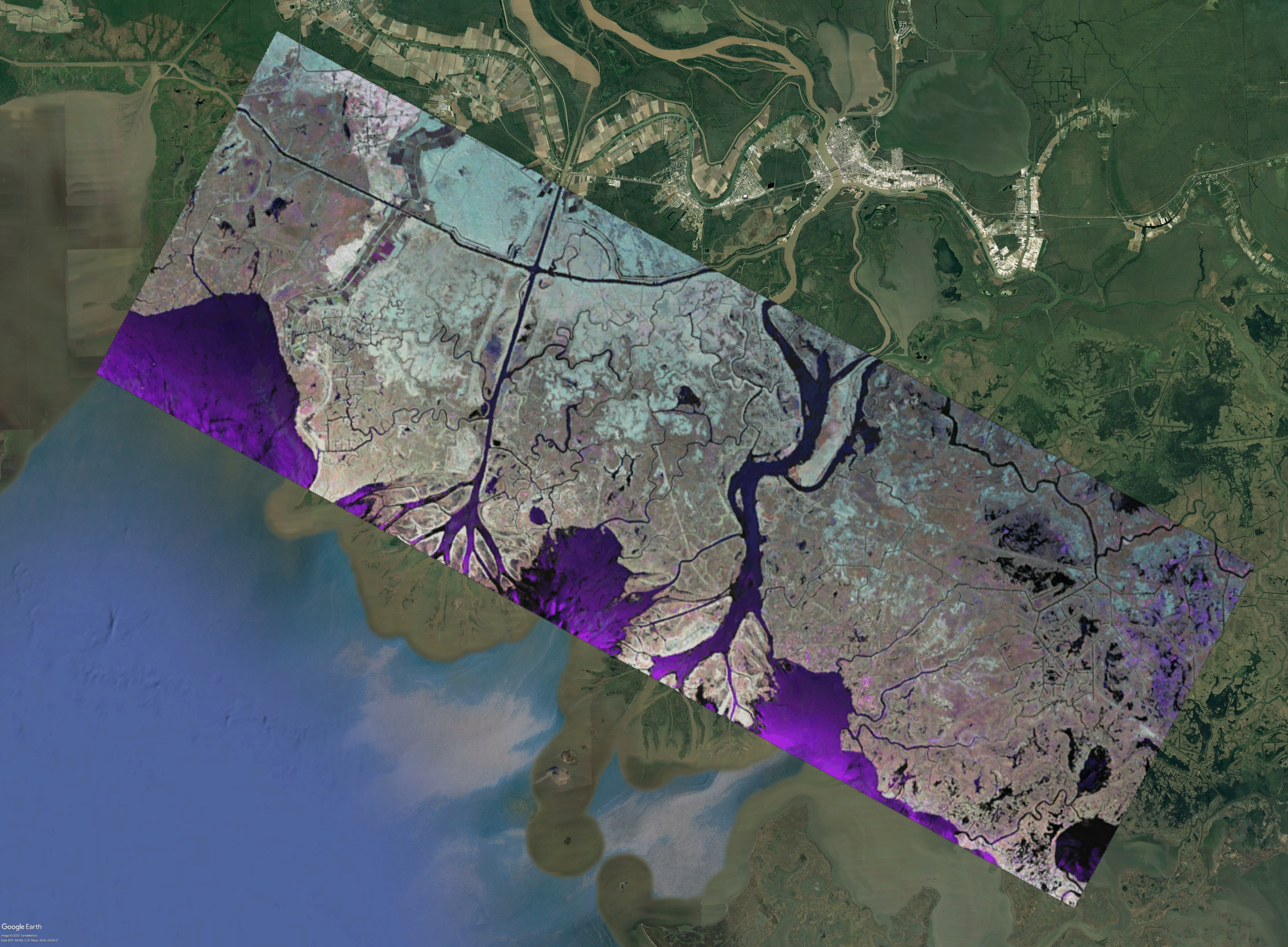
Pre-Delta-X: L1 UAVSAR Single Look Complex and Interferograms, MRD, LA, USA, 2016
This Level 1 (L1) dataset includes single look complex (SLC) stack products and co-registered interferograms in the HH (horizontal transmit and horizontal receive) polarization... -
Atmospheric Profiles: Brutsaert (FIFE)
Radiosonde observations from Wilf Brutsaert -
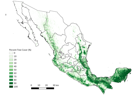
Soil Organic Carbon Distributions in Tidal Wetlands of the Northeastern USA
This dataset provides estimates of soil organic carbon (SOC) in tidal wetlands for the northeastern United States. The data cover the period 1998-2018. Northeastern U.S. tidal... -
LBA-ECO LC-03 SAR Images, Land Cover, and Biomass, Four Areas across Brazilian Amazon
This data set provides three related land cover products for four study areas across the Brazilian Amazon: Manaus, Amazonas; Tapajos National Forest, Para Western (Santarem);... -
LUH2-ISIMIP2b Harmonized Global Land Use for the Years 2015-2100
This dataset provides 0.25-degree gridded, global, annual estimates of fractional land use and land cover patterns for the period 2015-2100, designed to support the ISIMIP2b... -
Delta-X: Delft3D Sediment Model, Site 399, Terrebonne Basin, MRD, Louisiana, USA
This dataset contains the Delft3D model of the intensive site 399 in the Terrebonne Basin along the Mississippi River Delta (MRD) in coastal Louisiana. Simulations cover the... -
BOREAS CanSIS Regional Soils Data in Vector Format, V2
This data set contains soils data from the Canada Soil Information System (CanSIS) in ESRI Shapefile format for the provinces of Saskatchewan and Manitoba. They are provided as... -
Delta-X: Digital Elevation Model, MRD, LA, USA, 2021
This dataset provides an updated digital elevation model (DEM) for the Atchafalaya and Terrebonne basins in coastal Louisiana, USA. The DEM is updated from the Pre-Delta-X DEM... -
ISLSCP II Total Plant-Available Soil Water Storage Capacity of the Rooting Zone
This data set provides two estimates of the geographic distribution of the total plant-available soil water storage capacity of the rooting zone ("rooting zone water storage...

Official websites use .gov
A
.gov website belongs to an official government
organization in the United States.
Secure .gov websites use HTTPS
A
lock (
) or https:// means you’ve safely connected to
the .gov website. Share sensitive information only on official,
secure websites.