
-
Archive of Census Related Products (ACRP): 1990 Summary Tape File (STF1B)
The 1990 Summary Tape File (STF1B) portion of the Archive of Census Related Products (ACRP) contains population and housing data, along with additional demographic data for the... -
Global Human Modification of Terrestrial Systems
The Global Human Modification of Terrestrial Systems data set provides a cumulative measure of the human modification of terrestrial lands across the globe at a 1-km resolution.... -
Global 15 x 15 Minute Grids of the Downscaled Population Based on the SRES B2 Scenario, 1990 and 2025
The Global 15x15 Minute Grids of the Downscaled Population Based on the Special Report on Emissions Scenarios (SRES) B2 Scenario, 1990 and 2025, are geospatial distributions of... -
Compendium of Environmental Sustainability Indicator Collections: 2004 Environmental Vulnerability Index (EVI)
The 2004 Environmental Vulnerability Index (EVI) portion of the Compendium of Environmental Sustainability Indicator Collections contains 111 variables for 235 countries and... -
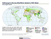
Anthropogenic Biomes of the World, Version 2: 1800
The Anthropogenic Biomes of the World, Version 2: 1800 data set describes anthropogenic transformations within the terrestrial biosphere caused by sustained direct human... -
2000 Pilot Environmental Sustainability Index (ESI)
The 2000 Pilot Environmental Sustainability Index (ESI) is an exploratory effort to construct an index that measures the ability of a nation's economy to achieve sustainable... -
HANPP Collection: Human Appropriation of Net Primary Productivity (HANPP) by Country and Product
The HANPP Collection: Human Appropriation of Net Primary Productivity (HANPP) by Country and Product contains tabular data on carbon-equivalents of consumption by country and by... -
China Dimensions Data Collection: China Administrative Regions GIS Data: 1:1M, County Level, 1 July 1990
The China Administrative Regions GIS Data: 1:1M, County Level, 1 July 1990 consists of geographic boundary data for the administrative regions of China as of 1 July 1990. The... -
Annual Mean PM2.5 Components (EC, NH4, NO3, OC, SO4) 50m Urban and 1km Non-Urban Area Grids for Contiguous U.S., 2000-2019 v1
The Annual Mean PM2.5 Components (EC, NH4, NO3, OC, SO4) 50m Urban and 1km Non-Urban Area Grids for Contiguous U.S., 2000-2019, v1 data set contains annual predictions of the... -
Spatial Data from the 2011 India Census
The Spatial Data from the 2011 India Census contains gridded estimates of India population at a resolution of 1 kilometer along with two spatial renderings of urban areas, one... -
Gridded Population of the World, Version 4 (GPWv4): Basic Demographic Characteristics, Revision 11
The Gridded Population of the World, Version 4 (GPWv4): Basic Demographic Characteristics, Revision 11 consists of estimates of human population by age and sex as counts (number... -
China Dimensions Data Collection: Priority Programme for China's Agenda 21
The Priority Programme for China's Agenda 21 consists of full-text program descriptions supporting China's economic and social development. The descriptions represent 69... -
West Africa Coastal Vulnerability Mapping: Subset of OpenStreetMap (OSM) Roads
The West Africa Coastal Vulnerability Mapping: Subset of OpenStreetMap (OSM) Roads data set includes roads within 200 kilometers of the coast and was extracted from the full OSM... -
Last of the Wild Project, Version 3 (LWP-3): 2009 Human Footprint, 2018 Release
The 2009 Human Footprint, 2018 Release provides a global map of the cumulative human pressure on the environment in 2009, at a spatial resolution of ~1 km. The human pressure is... -
West Africa Coastal Vulnerability Mapping: Point and Gridded Locations of Fatalities, 2008-2013
The West Africa Coastal Vulnerability Mapping: Point and Gridded Locations of Fatalities, 2008-2013 data set consists of two layers: points representing the location of conflict...

Official websites use .gov
A
.gov website belongs to an official government
organization in the United States.
Secure .gov websites use HTTPS
A
lock (
) or https:// means you’ve safely connected to
the .gov website. Share sensitive information only on official,
secure websites.