
-
ECCO Gent-McWilliams Ocean Bolus Velocity - Monthly Mean 0.5 Degree (Version 4 Release 4)
This dataset contains monthly-averaged Gent-McWilliams ocean bolus velocity interpolated to a regular 0.5-degree grid from the ECCO Version 4 revision 4 (V4r4) ocean and sea-ice... -
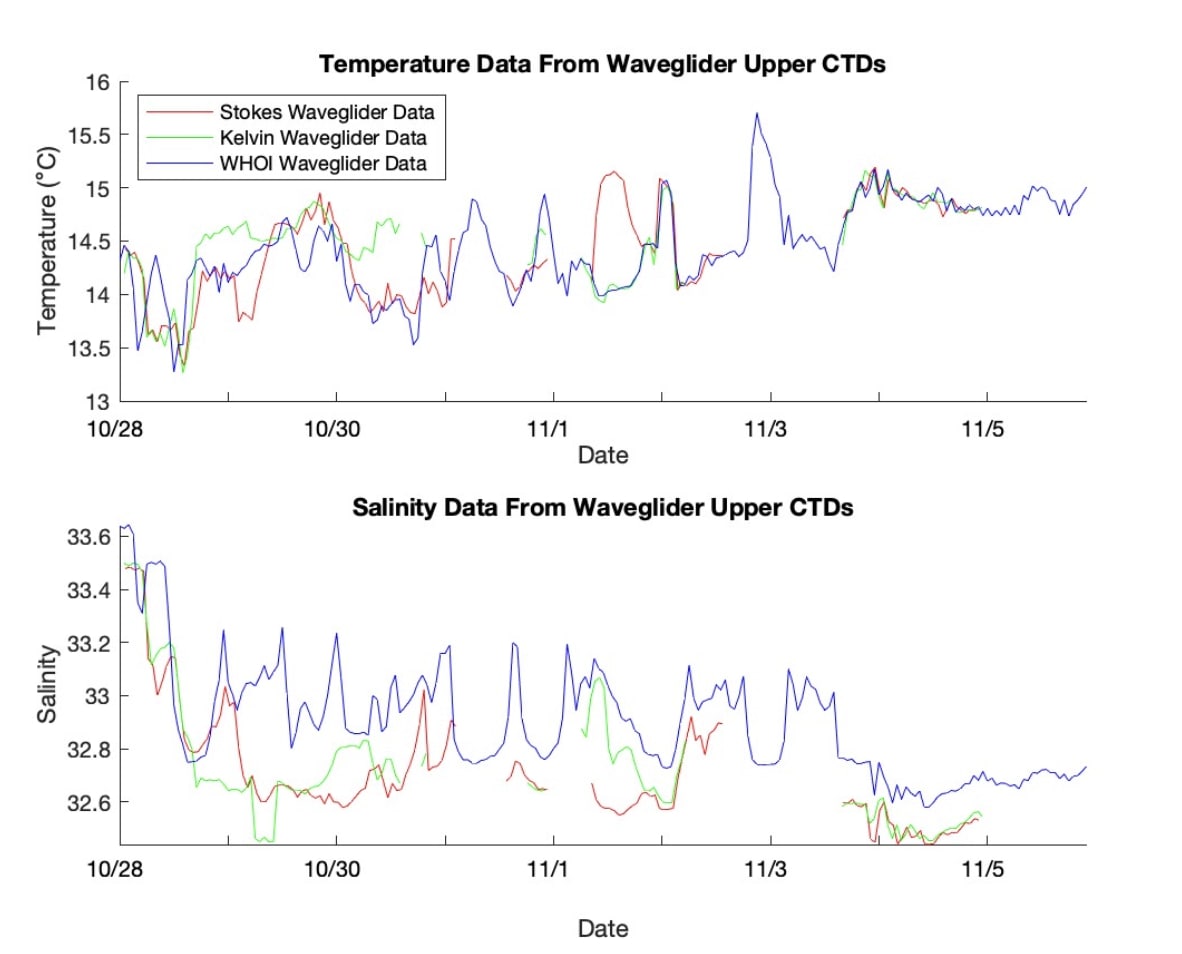
Waveglider data for the SPURS-1 N. Atlantic field campaign
The SPURS (Salinity Processes in the Upper Ocean Regional Study) project is an oceanographic process study and associated field program that aim to elucidate key mechanisms... -
Aquarius Official Release Level 3 Rain-flagged Sea Surface Salinity Standard Mapped Image Descending 28-Day Running Mean Data V5.0
Aquarius Level 3 sea surface salinity (SSS) rain-flagged standard mapped image data contains gridded 1 degree spatial resolution SSS averaged over daily, 7 day, monthly, and... -
SPURS-2 shipboard X-band radar backscatter data for the E. Tropical Pacific field campaign
The SPURS (Salinity Processes in the Upper Ocean Regional Study) project is a NASA-funded oceanographic process study and associated field program that aim to elucidate key... -
SPURS-2 research vessel Underway Salinity Profiling System (USPS) data for the E. Tropical Pacific R/V Revelle cruises
The SPURS (Salinity Processes in the Upper Ocean Regional Study) project is a NASA-funded oceanographic process study and associated field program that aim to elucidate key... -
MODIS Terra Level 3 SST Thermal IR 8 Day 4km Daytime V2019.0 NGDA
Day and night spatially gridded (L3) global NASA skin sea surface temperature (SST) products from the Moderate-resolution Imaging Spectroradiometer (MODIS) onboard the Terra... -
RSS SMAP Level 3 Sea Surface Salinity Standard Mapped Image 8-Day Running Mean V5.0 Validated Dataset
The version 5.0 SMAP-SSS level 3, 8-Day running mean gridded product is based on the fifth release of the validated standard mapped sea surface salinity (SSS) data from the NASA... -
S-MODE Waveglider Observations
This dataset contains waveglider observations from the Sub-Mesoscale Ocean Dynamics Experiment (S-MODE) field campaign. The experiment was conducted approximately 300 km... -
Aquarius Official Release Level 3 Rain-flagged Sea Surface Salinity Standard Mapped Image Seasonal Data V5.0
Aquarius Level 3 sea surface salinity (SSS) rain-flagged standard mapped image data contains gridded 1 degree spatial resolution SSS averaged over daily, 7 day, monthly, and... -
S-MODE PRISM Level 2a Reflectance Version 1
This dataset contains orthocorrected and atmospherically corrected water-leaving reflectance data from the Sub-Mesoscale Ocean Dynamics Experiment (S-MODE) during the IOP1... -
S-MODE Pre-Pilot Ocean Wave Slope from Visible-Band Polarimetry at the Air-Sea Interaction Tower Version 1
These wave slope data from polarimetry described below are considered preliminary and should not be used for any purpose without consulting Chris Zappa... -
Aquarius Official Release Level 3 Rain-flagged Sea Surface Salinity Standard Mapped Image Ascending 7-Day Data V5.0
Aquarius Level 3 sea surface salinity (SSS) rain-flagged standard mapped image data contains gridded 1 degree spatial resolution SSS averaged over daily, 7 day, monthly, and... -
OPERA Dynamic Surface Water Extent from Harmonized Landsat Sentinel-2 provisional product (Version 1)
This dataset contains Level-3 Dynamic OPERA provisional surface water extent product version 1. The data are provisional surface water extent observations beginning April 2023.... -
Boknis Pre-SWOT Level-4 Hourly MITgcm LLC4320 Native Grid 2km Oceanographic Dataset Version 1.0
This dataset provides a regional multivariate oceanographic state estimate from a global ocean numerical simulation with a focus on the Baltic Sea region. The global ocean... -
Aquarius Official Release Level 3 Ancillary Reynolds Sea Surface Temperature Standard Mapped Image Ascending 7-Day Data V5.0
Aquarius Level 3 ancillary sea surface temperature (SST) standard mapped image data are the ancillary SST data used in the Aquarius calibration for salinity retrieval. They are... -
CYGNSS Level 1 Calibrated Raw IF Version 1.0
This dataset contains the first release, Version 1.0, of the CYGNSS Calibrated Raw Intermediate Frequency (IF) based L1 Product. This product includes several established signal... -
ECCO Ocean and Sea-Ice Surface Freshwater Fluxes - Daily Mean 0.5 Degree (Version 4 Release 4)
This dataset contains daily-averaged ocean and sea-ice surface freshwater fluxes interpolated to a regular 0.5-degree grid from the ECCO Version 4 revision 4 (V4r4) ocean and... -
SPURS-1 research vessel Underway-CTD trajectory profile data for N. Atlantic Endeavor and Knorr cruises
The SPURS (Salinity Processes in the Upper Ocean Regional Study) project is an oceanographic process study and associated field program that aim to elucidate key mechanisms... -
ECCO Atmosphere Surface Temperature, Humidity, Wind, and Pressure - Monthly Mean 0.5 Degree (Version 4 Release 4)
This dataset contains monthly-averaged atmosphere surface temperature, humidity, wind, and pressure interpolated to a regular 0.5-degree grid from the ECCO Version 4 revision 4... -
GHRSST Level 2P Western Atlantic Regional Skin Sea Surface Temperature from the Geostationary Operational Environmental Satellites (GOES) Imager on the GOES-13 satellite (GDS version 2)
The Geostationary Operational Environmental Satellites (GOES) operated by the United States National Oceanic and Atmospheric Administration (NOAA) support weather forecasting,...

Official websites use .gov
A
.gov website belongs to an official government
organization in the United States.
Secure .gov websites use HTTPS
A
lock (
) or https:// means you’ve safely connected to
the .gov website. Share sensitive information only on official,
secure websites.