
-
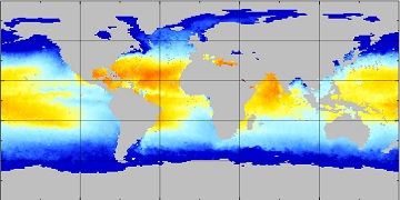
Aquarius Official Release Level 3 Sea Surface Spiciness Standard Mapped Image Annual Data V5.0
Aquarius Level 3 sea surface spiciness standard mapped image data contains gridded 1 degree spatial resolution spice data averaged over daily, 7 day, monthly, and seasonal time... -
ECCO Sea-Ice Velocity - Daily Mean 0.5 Degree (Version 4 Release 4)
This dataset contains daily-averaged sea-ice velocity interpolated to a regular 0.5-degree grid from the ECCO Version 4 revision 4 (V4r4) ocean and sea-ice state estimate.... -
S-MODE MASS Level 1 Lidar Point Cloud Version 1
This dataset contains geolocated airborne LiDAR point cloud measurements from the Sub-Mesoscale Ocean Dynamics Experiment (S-MODE) conducted approximately 300 km offshore of San... -
Aquarius Official Release Level 3 Sea Surface Spiciness Standard Mapped Image Ascending Seasonal Data V5.0
Aquarius Level 3 sea surface spiciness standard mapped image data contains gridded 1 degree spatial resolution spice data averaged over daily, 7 day, monthly, and seasonal time... -
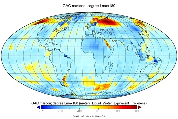
JPL GRACE/GRACE-FO Gridded-AOD1B Water-Equivalent-Thickness Surface-Mass Anomaly RL06.3 dataset for Tellus Level-3 mascon 0.5-degree grid
GRACE non-tidal high-frequency atmospheric and oceanic mass variation models are routinely generated at GFZ as so-called Atmosphere and Ocean De-aliasing Level-1B (AOD1B)... -
CYGNSS Level 3 Storm Centric Grid Science Data Record Version 1.0
This dataset contains the Version 1.0 Cyclone Global Navigation Satellite System (CYGNSS) Level 3 Storm Centric Grid (SCG) Science Data Record (SDR) which provides the average... -
RapidScat Level 1B Time-Ordered Geo-Located Sigma-0 Version 2.0
This dataset contains the ISS-RapidScat Version 2.0 Level 1B geo-located Sigma-0 measurements and antenna pulse "egg" and "slice" geometries as derived from ephemeris and the... -
Integrated Multi-Mission Ocean Altimeter Data for Climate Research complete time series Version 5.2
This dataset contains along track Sea Surface Height Anomalies (SSHA) from the TOPEX/Poseidon, Jason-1, OSTM/Jason-2, and Jason-3 missions geo-referenced to a mean reference... -
MODIS Aqua Level 3 SST Thermal IR Monthly 9km Daytime V2019.0 NGDA
Day and night spatially gridded (L3) global NASA skin sea surface temperature (SST) products from the Moderate-resolution Imaging Spectroradiometer (MODIS) onboard the Aqua... -
ECCO Atmosphere Surface Temperature, Humidity, Wind, and Pressure - Monthly Mean llc90 Grid (Version 4 Release 4)
This dataset provides monthly-averaged atmosphere surface temperature, humidity, winds, and pressure on the native Lat-Lon-Cap 90 (LLC90) model grid from the ECCO Version 4... -
SWOT Level 1B High-Rate Single-look Complex Data Product, Version 1.1
High rate data processed to single-look complex SAR images for each antenna. Gridded tile (approx 64x64 km2); half swath (left or right side of full swath). Available in... -
SASSIE Arctic Field Campaign Summary Ice Concentration Rankings from ML analysis of SBAND Images Fall 2022
This dataset contains ice concentration rankings of S-band images from the S-BAND marine navigation radar collected during the 2022 Salinity and Stratification at the Sea Ice... -
S-MODE L2 Shipboard Bottle Data Version 1
This dataset contains in-situ seawater samples taken during the Sub-Mesoscale Ocean Dynamics Experiment (S-MODE) conducted approximately 300 km offshore of San Francisco during... -
SWOT Satellite Reconstructed Attitude Data
Satellite attitude reconstructed from combination of onboard gyro and star tracker data. Daily 26-hour files centered at 12:00:00 (TAI) provide quaternions to represent the... -
PICO Mooring data for the SPURS-1 N. Atlantic field campaign
The SPURS (Salinity Processes in the Upper Ocean Regional Study) project is an oceanographic process study and associated field program that aim to elucidate key mechanisms... -
Aquarius Official Release Level 3 Sea Surface Spiciness Standard Mapped Image Descending Mission Cumulative Data V5.0
Aquarius Level 3 sea surface spiciness standard mapped image data contains gridded 1 degree spatial resolution spice data averaged over daily, 7 day, monthly, and seasonal time... -
MetOp-B ASCAT Scatterometer Inter-Calibrated ESDR Level 2 Ocean Surface Equivalent Neutral Wind Vectors and Wind Stress Vectors Version 1.1
This dataset contains ocean surface wind vectors (equivalent neutral and true 10m) and wind stress vectors derived from satellite-based scatterometer observations (the MetOp-B... -
Aquarius Official Release Level 3 Wind Speed Standard Mapped Image Ascending Monthly Climatology Data V5.0
Aquarius Level 3 ocean surface wind speed standard mapped image data contains gridded 1 degree spatial resolution wind speed data averaged over daily, 7 day, monthly, and... -
GRACE NON-TIDAL ATMOSPHERE AND OCEAN GEOPOTENTIAL COEFFICIENTS CSR RELEASE 6.0 GAC
FOR EXPERT USE ONLY. This dataset contains estimates of geopotential field derived from the Gravity Recovery and Climate Experiment (GRACE) mission measurements and a non-tidal... -
MetOp-B ASCAT Level 2 25.0km Ocean Surface Wind Vectors in Full Orbit Swath
This dataset contains operational near-real-time Level 2 ocean surface wind vector retrievals from the Advanced Scatterometer (ASCAT) on MetOp-B at 25 km sampling resolution...

Official websites use .gov
A
.gov website belongs to an official government
organization in the United States.
Secure .gov websites use HTTPS
A
lock (
) or https:// means you’ve safely connected to
the .gov website. Share sensitive information only on official,
secure websites.