
-
West Atlantic Pre-SWOT Level-4 Hourly MITgcm LLC4320 Native Grid 2km Oceanographic Dataset Version 1.0
This dataset provides a regional multivariate oceanographic state estimate from a global ocean numerical simulation with a focus on the West Atlantic region. The global ocean... -
NARSTO EPA Supersite (SS) Houston, Texas Air Quality Study 2000 (TexAQS2000) Department of Energy (DOE) G-1 Air Chemistry, Aerosol, and Met Data
NARSTO_EPA_SS_HOUSTON_TEXAQS2000_DOE_G-1_DATA is North American Research Strategy for Tropospheric Ozone (NARSTO) Environmental Protection Agency (EPA) Supersite (SS) Houston,... -
TRMM TMI/PR Combined Precipitation L3 1 month 0.5 degree x 0.5 degree V7 (TRMM_3B31) at GES DISC
This is a combined rainfall product. 3B31 uses the high quality retrievals done for the narrow swath in 2B31 to calibrate the wide swath retrievals generated in 2A12. For each... -
TRMM (TMPA-RT) Near Real-Time Precipitation L3 3 hour 0.25 degree x 0.25 degree V7 (TRMM_3B42RT) at GES DISC
TMPA (3B42RT) dataset have been discontinued as of Dec. 31, 2019, and users are strongly encouraged to shift to the successor IMERG datasets (doi: 10.5067/GPM/IMERG/3B-HH-E/06,... -
DISCOVER-AQ Texas Deployment Pandora Column Observations
DISCOVERAQ_Texas_Ground_Pandora_Data contains all of the Pandora instrumentation data collected during the Texas (Houston) deployment of NASA's DISCOVER-AQ field study.... -
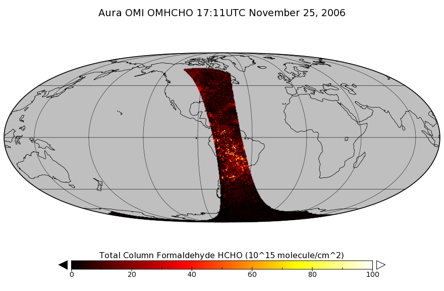
OMI/Aura Formaldehyde (HCHO) Total Column 1-orbit L2 Swath 13x24 km V003 (OMHCHO) at GES DISC
The Aura Ozone Monitoring Instrument (OMI) Version-3 Formaldehyde Product OMHCHO is now available from the NASA Goddard Earth Sciences Data and Information Services Center (GES... -
SEAC4RS DC-8 Aircraft In-Situ Cloud Data
SEAC4RS_Cloud_AircraftInSitu_DC8_Data are in-situ cloud data collected onboard the DC8 aircraft during the Studies of Emissions and Atmospheric Composition, Clouds and Climate... -
Soil Reflectance Data (FIFE)
Spectral reflectance of soils, Atlas of Soil Reflectance Properties (Stoner '80) -
FIREX-AQ Merge Data Files
FIREXAQ_Merge_Data are pre-generated merge data files collected during FIREX-AQ. These files contain merged data products collected onboard the DC-8 aircraft. Completed during... -
ECCO Ocean Mixed Layer Depth - Daily Mean 0.5 Degree (Version 4 Release 4)
This dataset contains daily-averaged ocean mixed layer depth interpolated to a regular 0.5-degree grid from the ECCO Version 4 revision 4 (V4r4) ocean and sea-ice state... -
BOREAS/AES Campbell Scientific 15-minute Surface Meteorological Data: 1996
Contains data from 1996 from the Atmospheric Environment Service Campbell Scientific autostations collecting continuous fifteen minute data for BOREAS. -
NAMMA SENEGAL RAIN GAUGE NETWORK V1
The NAMMA Senegal Rain Gauge Network consisted of 40 rain gauge sites (AMMA 1-40) located in various places throughout Senegal, West Africa. These data files were generated... -
TROPESS CrIS-SNPP L2 Ozone for Forward Stream, Summary Product V1 (TRPSYL2O3CRSFS) at GES DISC
The TROPESS CrIS-SNPP L2 Ozone for Forward Stream, Summary Product contains the vertical distribution of the retrieved atmospheric state of ozone (O3), and formal uncertainties... -
Lake Bathymetry Maps derived from Landsat and Random Forest Modeling, North Slope, AK
This dataset provides lake bathymetry maps derived from Landsat surface reflectance products for a portion of the North Slope area of Alaska. A random forest regression... -
ARCTAS DC-8 Aircraft In-situ Cloud Data
ARCTAS_Cloud_AircraftInSitu_DC8_Data is the in-situ cloud data for the DC-8 aircraft collected during the Arctic Research of the Composition of the Troposphere from Aircraft...

Official websites use .gov
A
.gov website belongs to an official government
organization in the United States.
Secure .gov websites use HTTPS
A
lock (
) or https:// means you’ve safely connected to
the .gov website. Share sensitive information only on official,
secure websites.